
Great Dreiherrenstein
The Große Dreiherrenstein (in short: Dreiherrnstein ) is a crossing point of several old trade routes on the Rennsteig in the Thuringian Forest .
location
The Dreiherrenstein is located directly on the Rennsteig at an altitude of 808 meters, about ten kilometers south of Ilmenau . It represents the center of the Rennsteig. It is also located on a watershed; the south is drained to the Weser via the sluice , in the north the Lengwitz and the Schorte , in the northeast the Schobse and to the east over the Ochsenbach into the Wohlrose . All are tributaries of the Ilm and thus the Elbe.
Only 500 m to the southeast is the 838 m high mountain Großer Dreiherrnstein , named after the intersection , which is the highest point in the area.
Historical
In its more than 400-year history, various principalities, duchies and kingdoms met at the great Dreiherrenstein, it was both a passport and a customs post. This is where Frauenwalder Strasse (coming from Ilmenau, on via Frauenwald to Eisfeld , part of the Lübeck - Nuremberg trade route), Rennsteig and Alte Langewiesener Strasse met .
Current
Today the Dreiherrenstein is the intersection of the streets Ilmenau - Neustadt am Rennsteig and Dreiherrenstein - Frauenwald. There is a restaurant, a bus stop and a parking lot for hikers. Currently, the boundaries of five communities on the Dreiherrenstein touch each other; these are Langewiesen, Neustadt am Rennsteig, Schleusegrund , Frauenwald and Stützerbach .
history
A first mention can be found in a Henneberg forest description from 1587. There he is called "Dreier Herren Stein" . The year 1596 is carved into the stone itself, the year it was erected. Initially, the stone separated the Principality of Schwarzburg-Arnstadt , the Duchy of Saxony-Eisenach and the County of Henneberg . After the Counts of Henneberg died out, the hen was initially replaced by the Saxon coat of arms. After the Congress of Vienna in 1815, the Principality of Schwarzburg-Sondershausen , the Grand Duchy of Saxony-Weimar-Eisenach and the Kingdom of Prussia met . In 1795 the offices of Eisfeld , Gehren and Schleusingen came together, and at that time their own three-man stone was set up.
photos

Restaurant at the Dreiherrenstein
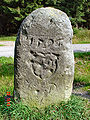
Northwest side of the boundary stone with the year (above), coat of arms of the Counts of Henneberg (center) and the KP for the Kingdom of Prussia (below)
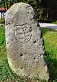
South-east side of the boundary stone with the coat of arms of the Duchy of Saxony-Eisenach

North-east side of the boundary stone with the year (above) and the coat of arms of the Principality of Schwarzburg-Sondershausen (center)


literature
- Thüringer Rennsteigverein eV (publisher): 400 years of the Großer Dreiherrenstein , Nötzold printing company, Neustadt am Rennsteig 1996.
- Ludwig, Otto: Der Rennsteig , Greifenverlag, Rudolstadt 1974/1991, ISBN 3735202233
Coordinates: 50 ° 36 ′ 36 ″ N , 10 ° 53 ′ 38 ″ E