
Groppenstein Gorge

The Groppenstein Gorge is a section of the Mallnitzbach gorge in the lower Mallnitz Valley in the market town of Obervellach in Carinthia , Austria .
Emergence
The hanging valley between Obervellach and Mallnitz , which is around 500 m higher, was shaped by the Ice Age and was created by the different thicknesses and deep erosion of the glacier flows in the Möll and Mallnitz valleys . After the glacier retreat , the increased meltwater runoff led to the Mallnitzbach gorge cutting deeply and thus to the formation of the Rabisch and Groppenstein gorges . These cut through the geological units of the Tauern window and the slate shell and are made up of waterfalls and poolsand accompanied by rock formations. At the level of Lassach, both gorges are interrupted by a leveled area with landslide masses from the Auernig . At the exit of the gorges, an alluvial cone spreads to the southern edge of the Mölltal. The gorge is named after Groppenstein Castle , located near the confluence of the Mallnitzbach in the Möll .
Canyon path
The entrance to the Groppenstein Gorge is in the village of Raufen at 692 m , where entry is paid at the historic toll tower. At the entrance, the “5-sensual wise head” invites you to enjoy the path with all your senses. The first part of the gorge trail leads over bridges and trails, through spruce and larch forest, past the Raufenfall with couloirs, rapids and bizarre rocks, to the 30 m high Groppenstein waterfall. Then the gorge narrows and leads along rock faces to the beginning of a climbing system made in 2011 made of wood and steel structures, which are mounted directly on the steep rock walls and open up the 40 m high Zechnerfall, where there is also a viewing platform. Then the exit takes place at 922 m , whereby the descent mostly takes place via Semslach-Straße and past Groppenstein Castle back to the start. The gorge path is around 2500 m long and leads over around 230 meters in altitude.
The Rabisch and Groppenstein gorges together form the longest gorge path in Carinthia. With the Raggaschlucht in nearby Flattach , they are part of the Upper Carinthian Schluchtenweg. It was realized with the support of the BMLFUW , the state of Carinthia and the EU .
hazards
The accessible from May to October Groppensteinschlucht holds as many walk-in gorges and ravines the risk of flooding, so they will be closed when rain. Due to an ÖBB hydropower plant that has been in operation in Mallnitz for many decades , which carries out an automatic flush at irregular intervals depending on the amount of water, there is a risk of a sudden surge of water, which is why bathing in the gorge is prohibited.
gallery
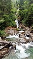
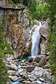
Starting area with a fight
Groppensteinfall
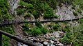
Schluchtsteig along the Mallnitzbach
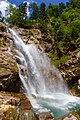
Schluchtsteig at the Zechnerfall


Web links
- Hohe Tauern National Park: gorges and gorges
- Experience sensory gorge Groppenstein gorge Obervellach
Coordinates: 46 ° 56 ′ 30 ″ N , 13 ° 11 ′ 0 ″ E