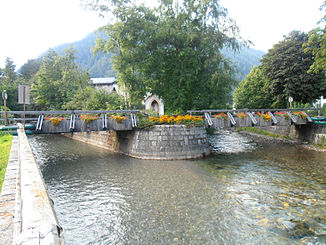
Mallnitzbach
| Mallnitzbach | ||
|
Confluence of the Seebach (right in the picture) |
||
| Data | ||
| location | Spittal an der Drau district , Carinthia , Austria | |
| River system | Danube | |
| Drain over | Möll → Drau → Danube → Black Sea | |
| origin | originates from the Tauernbach in the Mallnitz Tauern Valley | |
| muzzle | At Obervellach in the Möll coordinates: 46 ° 56 '2 " N , 13 ° 10' 55" E 46 ° 56 '2 " N , 13 ° 10' 55" E
|
|
| Catchment area | 121.5 km² | |
| Left tributaries | Seebach | |
| Communities | Mallnitz , Obervellach | |
The Mallnitzbach is a left tributary of the Möll . It emerges from the Tauernbach in the Mallnitz Tauern Valley . At Mallnitz it emerges into the wide valley floor of the Mallnitz valley and takes in the significantly larger Seebach coming from the Seebach valley . Between Stappitz and Lassach, the stream in the Rabisch Gorge cuts through a valley step created by Ice Age glaciers . At the end of the valley, the Dosenbach joins from the left. Below Lassach, in the Zechnerfall, it falls into the narrow Groppenstein Gorge , in the middle of which it forms the broad, approximately 30-meter-high Groppensteinerfall. At the end of the mountain spur in the sharp confluence of the Mallnitzbach and Möll valleys, Groppenstein Castle towers over the gorge. The Mallnitzbach flows into the Möll near the Obervellach district of Räuflach .
The name Mallnitz is interpreted as Kleine Möll . The place Mallnitz and the Mallnitz valley are named after the brook .
supporting documents
- ↑ List of areas of the Austrian river basins - Drau area. (No longer available online.) Federal Ministry of Agriculture, Forestry, Environment and Water Management , p. 28 , archived from the original on April 29, 2014 ; Retrieved April 28, 2014 . Info: The archive link was inserted automatically and has not yet been checked. Please check the original and archive link according to the instructions and then remove this notice.
- ↑ Untitled. Google Maps , accessed April 28, 2014 .
- ^ Eduard Hackel : The vegetation conditions of Mallnitz in Carinthia. P. 932 , accessed April 28, 2014 .
- ^ Mallnitz municipality. (No longer available online.) Witten , archived from the original on May 14, 2014 ; accessed on May 14, 2014 . Info: The archive link was inserted automatically and has not yet been checked. Please check the original and archive link according to the instructions and then remove this notice.
- ^ Gunnar Strunz : A detour to Mallnitz. In: Carinthia: nature and culture between the Alps and the Wörthersee. Trescher Verlag , p. 93 , accessed on May 14, 2014 .
- ↑ The Slavs. Mallnitz municipality , accessed on May 14, 2014 .
