Grub (Weißenstadt)
|
Grub
City of Weißenstadt
Coordinates: 50 ° 6 ′ 8 ″ N , 11 ° 55 ′ 45 ″ E
|
|
|---|---|
| Postal code : | 95163 |
| Area code : | 09253 |
Grub is a district of the city of Weißenstadt in the Upper Franconian district of Wunsiedel in the Fichtel Mountains .
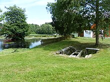
Grub is located behind Lehsten at a junction of the district road WUN 1 between Weißenstadt and Kleinschloppen . The Lehstenbach flows through the place. Architectural monuments are well troughs and a washing bench on the village green . A former milk pit colony is another architectural monument.
The place was first mentioned in a document in 1299 when it was sold to the Waldsassen monastery . It is laid out as a round with a village green and a village pond . There were soaps for tin making nearby . One chapel fell into disrepair during the Reformation . The place was heavily devastated in the Thirty Years War . In 1787 a shepherd's house and a trump house were named.
Web links
- Entry on the homepage of the city of Weißenstadt


