Voitsumra
|
Voitsumra
City of Weißenstadt
Coordinates: 50 ° 5 ′ 37 ″ N , 11 ° 50 ′ 51 ″ E
|
|
|---|---|
| Height : | 634 m |
| Residents : | 116 |
| Incorporation : | January 1, 1978 |
| Postal code : | 95163 |
| Area code : | 09253 |
|
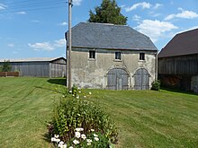
Voitsumra from the south
|
|
Voitsumra is a district of the Upper Franconian city of Weißenstadt .
location
The village is at an altitude of 635 to 645 meters on the state road St 2180 between Weißenstadt and Gefrees .
In the west of Voitsumra there is peat bog hell , northeast of the Weißenstädter See . The distance to the main town is a good three kilometers. The district is located in the northwest corner of the Fichtelgebirgshufeisens near the Rudolfstein , the Großer Waldstein , the Hohe Heide and the Wetzstein .
history
The first documentary mention was in 1346 as "Voytensumeraw", which probably meant the Vogt's summer house. In 1499 there were ten half farms and one whole farm there. In 1625 the residents were affected by the plague . Eight years later, in 1633, Voitsumra was looted and burned by "Croats and Pollaks" during the Thirty Years' War , and 13 men were shot. From 1818 to 1977 Voitsumra was a political municipality with the places Ruppertsgrün , Hühnerhöfen , Torfmoorhölle , Schönlind and Weißenhaid. This was incorporated into Weißenstadt on January 1, 1978 due to the regional reform in Bavaria .
Web links
Individual evidence
- ↑ a b Information about Voitsumra on the official website of Weißenstadt ( Memento from August 1, 2015 in the Internet Archive )
- ↑ a b Dietmar Herrmann: Fichtelgebirge, Bavarian Vogtland, Steinwald, Bayreuther Land - Lexicon . AckermannVerlag, Hof 2000, ISBN 3-929364-18-2 , p. 699 .


