High heath (mountain)
| High heather | ||
|---|---|---|
|
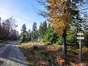
Hohe Heide - summit plateau |
||
| height | 848 m above sea level NN | |
| location | Bavaria | |
| Mountains | Fichtel Mountains | |
| Coordinates | 50 ° 4 ′ 13 " N , 11 ° 48 ′ 20" E | |
|
|
||
The Hohe Heide is a densely forested mountain in the Fichtelgebirge (northeast Bavaria), west of the Schneeberg .
geography
The Hohe Heide ( 848 m above sea level ) is the highest point of the Hohe Heide of the same name .
The village of Bischofsgrün is located south of the Hohe Heide.
Waters
The springs of Eger and Kornbach lie on the northern slope of the Hohe Heide, and the White Main flows past at the southern foot . The legendary Jesus fountain is located in the forest .
geology
In the western forest area lies the whetstone rock , which is a protected geotope.
Road link
To the south the federal road 303 ( Fichtelgebirgsstraße ) borders the mountain, to the north the state road No. 2180. To the west of the forest area runs the district road BT4 Bischofsgrün - Gefrees, to the east the district road BT13 / WUN1 Bischofsgrün - Weißenstadt. Until 1750 the Altstrasse Markgrafenweg ran across the mountain in a west-east direction.
Maps
- Fritsch hiking map of the Fichtelgebirge and Steinwald Nature Park No. 52, scale 1: 50,000
literature
- Dietmar Herrmann, Helmut Süssmann: Fichtelgebirge, Bavarian Vogtland, Steinwald, Bayreuther Land: Lexicon. Ackermannverlag, Hof (Saale) 2000, ISBN 3-929364-18-2 , p. 285.


