Camphausen pit
| Camphausen pit | |||
|---|---|---|---|
| General information about the mine | |||
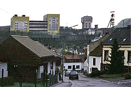
| View of the Camphausen pit with the reinforced concrete headframe (center) | |||
| Mining technology | Underground mining | ||
| Information about the mining company | |||
| Start of operation | 1871 | ||
| End of operation | 1990 | ||
| Successor use | industrial Estate | ||
| Funded raw materials | |||
| Degradation of | Hard coal | ||
| Geographical location | |||
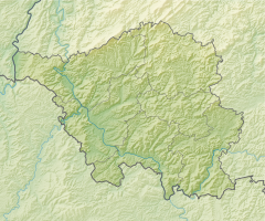
| Coordinates | 49 ° 17 '58.3 " N , 7 ° 1' 30.5" E | ||
|
|||
| Location | Fischbach-Camphausen | ||
| local community | Quiver | ||
| Regional Association ( NUTS3 ) | Saarbrücken | ||
| country | State of Saarland | ||
| Country | Germany | ||
| District | Saar | ||
The Camphausen pit is a former coal mine in the Fischbach-Camphausen district of the Saarland community of Qui Various .
history
The sinking of the Fischbach shafts I and II in the Fischbach valley began in 1871. Broken clay pots, bones and ashes were found while the two shafts were being sunk. They were the remains of a Celtic sacrificial site. A third shaft was added in 1874 . The mine was named "Grube Camphausen" in the same year on the occasion of a visit by the then Prussian Finance Minister Otto Camphausen . From 1877, the production operation was expanded and a railway line built.
On March 17, 1885, when a new shaft was being sunk, a severe firedamp and coal dust explosion occurred , in which 180 people died and another 30 were injured. When production had to be temporarily stopped in September 1895 after a fire in a hoisting machine building , the workforce was transferred to the neighboring pits.
Shaft IV was sunk in 1908. For lack of space, a decision was made against a steel headframe and a hammer head tower made of reinforced concrete was built. It was the world's first conveyor system of its kind. The winding tower, completed in 1912, is one of the historical landmarks of civil engineering in Germany, as designated by the Federal Chamber of Engineers . The tower is 40.7 meters high and stands on four supporting pillars, each of which goes eleven meters below the ground. There are two on the top floor Carriers of the company AEG , each with 1,740 kilowatts of power. There is space for the machine operator in the tower's bay windows .
In 1988 it was decided to close the mine in 1990. On January 1, 1990 Camphausen lost its independence and became part of the new Reden-Camphausen composite mine together with the Reden mine. The last hard coal was mined in November 1990.
Current usage
Large parts of the site and the conveyor facilities are no longer used and lie fallow. Part of it was converted into an industrial area.
Dump Lydia
Once the capacity of the heap Camphausen, which on the other side of the Fischbach Valley Railway is located was exhausted, the landfill was Bergehalde Lydia started. It was started as a cone slope and between 1979 and 1982 it was covered with a table mountain . From 2003 to 2006 the heap was then re-contoured. This became necessary because of the risk that the heap could slide onto the nearby railroad tracks and fires inside the heap. For this purpose, 400,000 cubic meters of tailings were removed from the top and a new surface was leveled. In addition, the surface was also compacted, sand was blown inside to suffocate the fires and new paths were laid. The heap has been used as a recreational area since 2006. It has two climbs on opposite sides. The highest point is at 360 m above sea level. NHN and the nearby plateau extends over twelve hectares. There are three pools of water on this plateau, which are named Heavenly Mirrors because they reflect the sky when they are filled with rainwater.
Around the year 2000, the Haldenrundweg was created as part of the Saar Regional Park project , which connects the Lydia tip with other heaps that are located around the Saar coal forest .
In 2009, the conversion of the mine dump into a training course for biathlon was prevented by a signature campaign. In the same year young people from Fischbach and Quiigart built a way of the cross on the heap. It consists of seven stations, including a summit cross . The crosses were made from materials from the mining industry and some refer to current issues.
literature
- Delf Slotta: The Saarland coal mining industry . Ed .: RAG Aktiengesellschaft and Institute for Regional Studies in Saarland eV Krüger Printing and Publishing, Dillingen / Saar 2011, ISBN 978-3-00-035206-5 .
- Herbert Pfeifer: Camphausen, history and stories . Self-published, Saarbrücken-Dudweiler 2010 ( OPAC entry ).
Individual evidence
- ↑ a b c d Michael Kipp: The silent Lydia and the hammer head. Saarbrücker Zeitung , October 29, 2017, accessed on February 2, 2020 .
- ↑ Historical names of Saarland pits ( Memento of the original from September 28, 2013 in the Internet Archive ) Info: The archive link was inserted automatically and has not yet been checked. Please check the original and archive link according to the instructions and then remove this notice.
- ↑ Brief history of the Camphausen mine
- ^ The Camphausen IV conveyor tower on the website of the landmarks of civil engineering, accessed on May 16, 2018.
- ↑ a b Morphoses - Agency for Art and New Media: Der Haldenrundweg . with hiking map. Ed .: Ministry for the Environment of Saarland. 2nd Edition. Saarbrücken August 2006 ( online [PDF; 2.6 MB ]).
- ↑ Elmar Müller: A way of industrial culture. Saarbrücker Zeitung , September 29, 2008, accessed on March 14, 2020 .
- ↑ Review: Ecumenical Way of the Cross on April 2, 2017. Parish Community Quiigart, accessed on February 2, 2020 .


