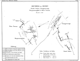
Pit House Nassau
| House Nassau | |||
|---|---|---|---|
| General information about the mine | |||
| Ground plan of the pits Grace of God, Pole Balance, Bergmannsglück and House Nassau | |||
| Mining technology | Tunnel construction | ||
| Information about the mining company | |||
| Start of operation | before 1757 | ||
| End of operation | 1938? | ||
| Funded raw materials | |||
| Degradation of | copper | ||
| Geographical location | |||
| Coordinates | 50 ° 42 '59.3 " N , 8 ° 13' 25.4" E | ||
|
|||
| Location | Donsbach | ||
| local community | Dillenburg | ||
| country | State of Hesse | ||
| Country | Germany | ||
| District | Dillenburg mountain area | ||
The Haus Nassau mine was a copper mine near Donsbach ( Dillenburg municipality ) in the Lahn-Dill district . The pit was on Berg Rutsch, southwest of Donsbach.
Aisle means
The gangway was within a band made of Schalstein, which stretched from above Donsbach via Nanzenbach to Hirzenhain . The pits on this passage train were:
- Old hope near Langenaubach
- Bar scales , mine luck for miners , God's grace near Donsbach
- Rose garden at Sechshelden
- Nicolaus and Fortunatus near Dillenburg
- Alte Lohrbach, Neuermuth, common colliery near Nanzenbach
The pit built up of several short, quartz leading chalcopyrite means having a thickness having 15 to 18 cm. The ores that were present consisted of copper brown and copper ore , some constricted copper pebbles and fibrous malachite .
The mine markedscheidete north with the mines Bergmannsglück and Stangenwage and partly built on the same corridors. The Maria mine near Schönbach was (far away) on a southern continuation of the corridors.
history
Mining activities existed on the south side of the Rutsch mountain before 1757, because the Haus Nassau mine supplied ore for smelting for the first time in 1757. The ores from the mine were melted in the Dillenburger Isabellenhütte . The Oranisch Nassau calendar reported in 1772 that on a Kux (share) of the pit house Nassau 1771 in the quarter Trinit. 22 1/2 Kreuzer yield were paid off. In 1827 the union consisted mainly of self-employed workers and was therefore rather weak financially. Cramer therefore described the prospects for the costly development of new deposits from the mine as not very positive. A tunnel , which was 400 m long in 1885, led into Berg Rutsch. It was about 365 m above sea level. NN (15 laughs higher than the deep tunnel of the rod wagon pit and 10 laughs higher than the deep tunnel of the Bergmannsglück mine). Due to the self-sufficiency efforts of the German Reich in the 1930s, the Mannesmannröhren-Werke took over the majority of the Kuxe at Haus Nassau and Colonia I in 1938.
advancement
Until 1774, only 710 quintals of copper ore were mined with little use. Becher described the quality of the ore as poor and the mine was known more for its beautiful minerals in (Nassau) at home and abroad than for its productivity.
closure
The pit was closed due to the exhaustion of the deposits.
geology
In the southeast and east of the Rhenish Slate Mountains lies the so-called "Hessian Synklinorium", which also includes the Lahn-Dill area . The Hessian Synclinorium , which was formed by thrusting and folding in the Paleozoic ( Devonian ), has a complicated geological structure. It is characterized by fault lines, uplifts and faults. There are no large contiguous deposits in the Lahn-Dill area.
See also
literature
- Ernst Frohwein: Description of the Dillenburg mountain area . Bonn 1885.
Individual evidence
- ↑ a b c The mining and metallurgical industry in the Duchy of Nassau: statist. News, geognost., Mineralog. u. techn. Descriptions d. Deposits of usable minerals, d. Mining u. Hüttenbetriebes, Volume 1, Ed. F. Odernheimer, Publisher: CW Kreidel, 1867, Wiesbaden
- ^ A b Ernst Frohwein: Description of the Dillenburg mountain area . Bonn 1885.
- ^ A b Ludwig Wilhelm Cramer: Geognostic fragments of Dillenburg and the surrounding area . Giessen 1827, p. 118 .
- ^ A b Johann Philipp Becher: Mineralogical description of the Oranien-Nassauische Lande: together with a history of the Siegen smelting and hammering industry . 1789.


