
Vossbeck mine
| Vossbeck mine | |||
|---|---|---|---|
| General information about the mine | |||
 |
|||
| Mining technology | Open pit | ||
| Information about the mining company | |||
| Operating company | Rheinkalk GmbH Dornap plant | ||
| Funded raw materials | |||
| Degradation of | limestone | ||
| Geographical location | |||
| Coordinates | 51 ° 15 '18.8 " N , 7 ° 4' 6.7" E | ||
|
|||
| Location | Wieden | ||
| local community | Wuppertal | ||
| Independent city ( NUTS3 ) | Wuppertal | ||
| country | State of North Rhine-Westphalia | ||
| Country | Germany | ||

The pit Voßbeck is a limestone - quarry in the Upper Devonian Massenkalk the west of Wuppertal in the municipality Vohwinkel on the border with Wülfrath . The quarry, located northwest of Wieden , is named after the former location of Vossbeck (also Vossbeek ), which has completely disappeared due to mining. To the south of the pit runs Düsseldorfer Straße , classified as Bundesstraße 7 , and to the east, Wiedener Straße , which is classified as Landesstraße 74 . Opposite the other side of the Wiedener Straße is the Schickenberg mine in the east . Both pits are connected by a tunnel below the federal road 224. Another tunnel that crosses under Düsseldorfer Straße connects Vossbeck with the Hanielsfeld mine in the south.
The pit measures around 650 meters in the west-east extension and around 360 meters in the north-south extension (this refers to the area that is closed to the public). The mine is operated by Rheinkalk GmbH Werk Dornap (with company headquarters in Wülfrath). The bottom is around 60 meters below ground level in the area (based on Wieden, which is around 190 meters above zero).
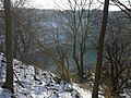
Look into the pit.

3D model of the pits near Dornap. From left to right: pit Hahnenfurth , pit Haniel field , mine Voßbeck and pit Schickenberg .

Web links
- Rheinkalk presents: The Dornap plant PDF file
- Geological-hydrogeological mapping in the area of the Herzkämper Mulde on sheet 4708, Wuppertal-Elberfeld
Individual evidence
- ^ Paul Reising: News from the Eulenkopfweg. the history of stones, plants, animals and people on the north-western edge of the city of Wuppertal 1994, ISBN 3-87093-068-3
- ↑ measured in Google Earth