Wieden (Wuppertal)
|
Wieden
City of Wuppertal
Coordinates: 51 ° 15 ′ 11 " N , 7 ° 4 ′ 23" E
|
||
|---|---|---|
| Height : | approx. 185 m above sea level NHN | |
|
Location of Wieden in Wuppertal |
||
|
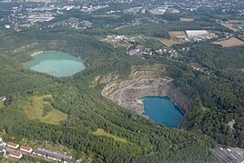
Aerial photo of Wieden (above the Vossbeck mine)
|
||
Wieden is a town located in the north of Wuppertal municipality Vohwinkel .
topography
The location is at the intersection of federal highway 7 , here called Düsseldorfer Strasse , with federal highway 224 coming from the south , known as Bahnstrasse , which continues northwards from the location as state road 74 ( Wiedener Strasse ).
Neighboring locations are Kirchenhöhe , Schickenberg , An der Piep , Bück , Saurenhaus , Sandfeld , Buntenbeck and Dornap .
history
The Wieden estate was first mentioned in a document in 1478 and then again in 1480.
In earlier times the location was at the intersection of two old streets . The route of the Wiedener Strasse and Bahnstrasse used to be part of the Werdenschen Kohlenstrasse , which dates back to the 14th century and on whose route the Essen – Solingen Provincial Road was laid in 1815 . The Düsseldorfer Straße connected the cities of Elberfeld and Düsseldorf and was qualified as Reichsstraße 7 in 1934.
The place is recorded as Hof Wieden on the Topographia Ducatus Montani by Erich Philipp Ploennies from 1715. It was divided into two parts in the 19th century. In the 19th century, the eastern part of the town was part of the municipality of Sonnborn, which was split off from the mayor's office in Haan in 1867 and which was renamed the municipality of Vohwinkel in 1888 with the transfer of territory to the city of Elberfeld . In the middle of the place ran the border to Honschaft and later subdüssel of the mayor's office Wülfrath , so that there was also a Wülfrath part of Wieden, which was called Wiedenerhäuschen at the time . The name went on a pub for traveling teamsters back, which was cultivated until the 20th century. Both sub- locations were recorded as Wiednerhäuschen in the 19th century on the topographical survey of the Rhineland (1824) and the Prussian first survey (1843).
In 1815 109 people lived in the Wülfrath part. According to the statistics and topography of the Düsseldorf administrative district from 1836, the Wülfrather part of Wieden was categorized as arable land and called Am Wiedenerhäuschen . At that time the suburb had nine houses and six agricultural buildings. 135 inhabitants lived in the village, 34 of them Catholic and 101 Protestant. No information is available about the Sonnborn part.
According to the community encyclopedia of the Kingdom of Prussia , the Wülfrath part, still called Wiedenerhäuschen, had two houses with 23 inhabitants in 1888, the Sonnborn part called Wieden had seven houses with 84 inhabitants.
When Wuppertal was founded in 1929, the city limits were moved a few hundred meters to the west as part of an area swap and the development of both suburbs as a whole was assigned to the newly founded city under the name of Wieden. On March 30, 1929, the Wieden – Elberfeld tram line went into operation.
The local situation hardly changed until the 20th century, until limestone quarrying by Rheinkalk GmbH Werk Dornap (with company headquarters in Wülfrath) around Wieden and neighboring Dornap changed the landscape extensively. To the east of Wiedener Straße , which leads north to Neviges , is the Schickenberg mine and to the west of Wiedener Straße is the Voßbeck mine . These two pits are connected by a tunnel below Wiedener Strasse . The Vossbeck pit is also connected to the Hanielsfeld pit by a tunnel , this pit is located southwest of Wieden. Hanielsfeld is separated from Vossbeck from Düsseldorfer Strasse (Bundesstrasse 7). The area north and east of Wieden belonged to Wülfrath until December 31, 1974, when it was also incorporated into Wuppertal. The Wiedener street was named on 7 December 1975 following the local situation.
Individual evidence
- ↑ Wilfried Heimes: The beginnings of the district Sonnborn in the Bergisches Land and their development - a settlement-geographic study ; Inaugural dissertation, Philosophical Faculty of the University of Cologne; 1961
- ↑ a b Kohlenstraßen zeitspurensuche.de, accessed October 2013
- ↑ a b Wolfgang Stock: Wuppertal street names . Thales Verlag, Essen-Werden 2002, ISBN 3-88908-481-8
- ↑ The historical Vohwinkel with a picture of the Wiedener Häuschen and the Wiedener Hof, accessed in January 2010
- ↑ a b Johann Georg von Viebahn : Statistics and Topography of the Administrative District of Düsseldorf , 1836
- ↑ Königliches Statistisches Bureau (Prussia) (Ed.): Community encyclopedia for the Rhineland Province, based on the materials of the census of December 1, 1885 and other official sources, (Community encyclopedia for the Kingdom of Prussia, Volume XII), Berlin 1888.
- ^ The historical Vohwinkel , accessed January 2010


