Pit head
| Pit head | ||
|---|---|---|
|
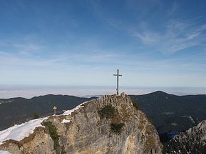
Pit head, summit construction from the south |
||
| height | 1839 m above sea level NHN | |
| location | Bavaria , Germany | |
| Mountains | Ammergau Alps | |
| Coordinates | 47 ° 34 '45 " N , 10 ° 52' 8" E | |
|
|
||
| rock | limestone | |
| Normal way |
Kenzenhütte - Bäckenalmsattel - Grubenkopf |
|
The pit head is a pronounced 1839 m above sea level. NHN , according to other sources 1847 m high summit in the Klammspitzkamm in the Ammergau Alps .
summit
The summit is easy to reach from the south via the moderately steep grass and pine slope. Small trails lead up the mountain from the Hirschwanghütte ( 1706 m above sea level ) to the southeast or from the Buchinger Rosstall from the northwest . The northeast flank drops from the summit in a vertical rock face and then turns into steep craggy terrain . At the highest point there is a large summit cross .
literature
- Dieter Seibert: Alpine Club Guide Allgäu and Ammergau Alps . 17th edition. Bergverlag Rother , Munich 2008, ISBN 978-3-7633-1126-2 , p. 379 ( limited preview in Google Book Search [accessed January 9, 2011]).
- Area map UK L 10 of the Bavarian State Office for Surveying 2007
Individual evidence
- ↑ Federal Agency for Cartography and Geodesy , State Office for Surveying and Geoinformation Bavaria : Digital Topographic Map 1:25 000, BayernAtlas , accessed on January 9, 2016
- ↑ Alpine Club Guide, p. 379

