Guadalupe (island)
| Guadalupe | |
|---|---|
| Southeast coast of the island of Guadalupe | |
| Waters | Pacific Ocean |
| Geographical location | 29 ° 0 ′ N , 118 ° 16 ′ W |
| length | 35 km |
| width | 9.5 km |
| surface | 244 km² |
| Highest elevation | Monte Augusta 1298 m |
| Residents | 213 (2010) <1 inh / km² |
| main place | Campo Oeste |
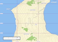
| Map of Guadalupe | |
Guadalupe (Spanish Isla Guadalupe ) is an island of volcanic origin located about 240 kilometers west of the Mexican Baja California peninsula . The island belongs to the Ensenada community of the state of Baja California .
population
The only inhabited village with 15 buildings (as of 2008) is Campo Oeste on the west coast. There used to be a small fishing village on the east coast of the island, Campo Este , but this settlement is now deserted. In the south there is a weather station, Campamento Sur . In the northern interior of the island is Campo Bosque , which was built in 1999 as a temporary camp in the cypress forest. The camp is home to members of an agricultural cooperative that removes goats from the island and sells them in the state of Sonora, with the permission of the Secretariat for Environment and Natural Resources and the assistance of the Navy Secretariat.
geography
The island has a length of approx. 40 km and a width of up to 9.5 km. The highest point on the 244 km² island is the 1,298 meter high Monte Augusta . Around the island there are still some smaller rocks protruding from the sea.
cards
Flora and fauna
fauna
Some of the typical animal species for this island also visit the nearby California Channel Islands . The large seal colonies are characteristic of Guadalupe . They represent the prey of great white sharks, which are numerous off the coast and are sometimes part of tourist expeditions. The coastal species native to the coast are the northern elephant seal and the endemic Guadalupe fur seal . Native bird species include the Guadalupe rock wren (Salpinctes obsoletus guadalupensis) and a subspecies of the house bullfinch (Carpodacus mexicanus amplus), the Guadalupe ruby-cockle (Regulus calendula obscurus) is probably already extinct. Also extinct the Guadalupe Karakara and Guadalupe-shaft rotor (a petrels -type), and the local sub-types of bush Wren (Thryomanes bewickii brevicauda), Flicker (Colaptes cafer rufipileus) and the base bunting (Pipilo maculatus consobrinus). A big problem for the bird world is that of poaching domestic cats .
flora
There are also numerous endemic species among the plants, such as the Guadalupe cypress and the Guadalupe palm ( Brahea edulis ). The island's flora was badly damaged by domestic goats . Russian whalers introduced them in the early 19th century. At times there were over a thousand goats, eating all plants more than a few centimeters high. Only after the Mexican government had evacuated the last goats in June 2005, a biosphere reserve could be established.
literature
- Joseph R. Jehl, Jr. and William T. Everett: History and status of the avifauna of Isla Guadalupe, Mexico. In: Transactions of the San Diego Society of Natural History, Volume 20, Number 17, pp. 313-336, January 30, 1985 ( online at archive.org )
- Lothar Müller: Judith Schalansky : Guadalupe . In: Süddeutsche Zeitung , February 4, 2017, p. 22 ( online )
- Thomas Oberbauer: A Comparison of Estimated Historic and Current Vegetation Community Structure on Guadalupe Island, Mexico. Institute for Wildlife Studies, Proceedings of the Sixth California Islands Symposium, Ventura, 2003, pp. 143-153 ( online )
Web links
- photos
- Guadalupe in the Global Volcanism Program of the Smithsonian Institution (English)
Individual evidence
- ↑ Note: Map and legend are not included in Schalansky's Atlas of the Remote Islands .
- ↑ Online version without the map printed on the newspaper page


