Lokon Empung
| Lokon Empung | ||
|---|---|---|
|
The Gunung Lokon |
||
| height | 1580 m | |
| location | Sulawesi ( Indonesia ) | |
| Coordinates | 1 ° 21 '24 " N , 124 ° 47' 46" E | |
|
|
||
| Type | Stratovolcano | |
| Last eruption | 2013 | |
|
Plume of smoke from Tompaluan crater on July 10, 2011 |
||
|
Lokon and Empung seen from Manado, around 1900–1925 |
||
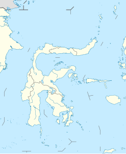
The Lokon Empung is a twin volcano on the Indonesian island of Sulawesi . It is located around 15 kilometers south of the city of Manado west of Tomohon in the Minahasa district of the Sulawesi Utara province and is one of the most active volcanoes on the island.
construction
The two stratovolcanoes originated on the northern edge of the Tondano caldera . With a height of 1580 meters, the Lokon is the higher and at the same time older of the two mountains. The Lokon has no crater ; There are no known eruptions in historical times. It consists of pyroclastic sediments and lava flows , which are composed of basalt and olivine . Later, a good two kilometers to the north-northeast, the 1340 meter high embankment was built . It broke out frequently between 1350 and 1800. At the southern foot of the Lokon is located Irang , one of rhyolite existing lava dome , is not known to whether before or after the Empung emerged. Since the 19th century, all volcanic eruptions have started from the Tompaluan crater , which is located at around 1140 meters in the saddle between the Lokon and the Empung . The Tompaluan temporarily contains a crater lake .
outbreaks
The volcanic eruptions in historical times were predominantly small to moderate explosive eruptions with a volcanic explosivity index (VEI) of one to three. Occasionally lava domes formed or pyroclastic currents occurred .
There were no injuries when the volcano erupted in 1986, when a 1,000-meter-high cloud of black smoke was thrown into the air.
On September 19, 1991, the Tompaluan broke out and pushed a cloud of smoke almost a kilometer high into the sky. Glowing tephra set fire to the fields of seven surrounding villages. More powerful eruptions from October 25th damaged around 1900 houses and around 3 km² of plantings; about 10,000 people were evacuated. Further outbreaks in November caused panic among residents who had since returned to their homes. Swiss volcanologist Vivianne Clavel has been missing since the October 24 eruption . According to witnesses, she was hit by ejected blocks and buried under ashes .
Due to frequent earthquakes and increased gas leaks, around 5,000 people were evacuated from the area around Lokon-Empung in July 2011. In mid-July there were several eruptions in which eruption columns rose up to 3.5 kilometers high. Most of the evacuees were able to return to their homes at the end of July; an area within three kilometers of the Tompaluan crater was still closed. The Tompaluan remained active with further eruptions until 2013.
Web links
- Lokon-Empung in the Global Volcanism Program of the Smithsonian Institution (English)
- University of North Dakota: Lokon, Sulawesi, Indonesia
Individual evidence
- ^ MG Morrice, PA Jezek, JB Gill, DJ Whitford, M. Monoarfa: An introduction to the Sangihe arc: Volcanism accompanying arc — Arc collision in the Molucca Sea, Indonesia. In: Journal of Volcanology and Geothermal Research. 19 (1983) doi : 10.1016 / 0377-0273 (83) 90129-4 , pp. 135-165, here p. 143.
- ↑ Lokon-Empung - Monthly Report 10/1991 in the Global Volcanism Program (English, accessed on February 16, 2013).
-
^ Lokon-Empung - Monthly reports 6/2011 and 11/2011 in the Global Volcanism Program (English, accessed on February 17, 2013).
Video of an eruption on September 21, 2012: Huge volcanic eruption of the Lokon. Retrieved September 21, 2012 . Lokon-Empung - weekly reports from February 2012 in the Global Volcanism Program (English, accessed on March 28, 2013)


