
Höhenburg (summit)
| Hilltop castle | ||
|---|---|---|
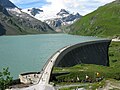
.jpg) View from the dam |
||
| height | 2108 m above sea level A. | |
| location | Salzburg , Austria | |
| Mountains | Glockner Group , Hohe Tauern | |
| Coordinates | 47 ° 10 '12 " N , 12 ° 43' 23" E | |
|
||

The hilltop castle is 2108 m above sea level. A. high summit in the Glockner group in the Austrian state of Salzburg , which is located in a high mountain landscape and is surrounded by more than ten three-thousand-meter peaks and two high-mountain reservoirs.
Location and surroundings
The mountain lies between the two high mountain reservoirs Wasserfallboden (in the north) and Mooserboden (in the south). The closest place is Kaprun . Neighboring peaks are the Hohe Tenn (3,368 m) in the east, the Kleine Grießkogel (2,669 m) in the west and the Kitzsteinhorn (3,203 m) in the northwest .

View from the summit of the Mooserboden
View from the foot of the Höhenburg on the Mooserboden

View from the Hohen Tenn (3368 m) to the Höhenburg

The Höhenburg (left) between Mooser and Drossensperre


Access
From the end of May to mid-October, Verbund AG will set up a transfer from Kaprun (Kesselfall, parking garage nearby) to the Mooserboden reservoir, which consists of three sections. First, a bus goes to the valley station of the Lärchwand inclined elevator (1,209 m), Europe's largest inclined elevator. It covers an altitude of 431 meters to its mountain station (1,640 m). Another subsequent bus route leads directly to the Mooserboden reservoir. The total transfer time is around 45 minutes. After crossing the dam (Moosersperre), the ascent to the summit can take place via a hiking trail (approx. 15 min.) Or three different via ferratas (approx. 20–30 min.).
Via ferratas
The summit can be reached via the following three via ferrata with different requirements ( difficulty and altitude in brackets): Mooser-Mandl (C / D, 110 m), Drossen-Hex (up to E, 100 m) and Limberg-Zwerg (B / C , 50 m). The descent is on a hiking trail. Since 2017 it has also been possible to cross the dam on a via ferrata ("MOBO 107", to B / C).
Others
In 2013 a wooden cross was erected on the summit. A zip line (Flying Fox) is operated on some days in summer .
Web links
- Via ferrata routes on bergstieg.com - accessed on January 21, 2017
- Via ferrata routes on schall-verlag.at - accessed on January 21, 2017
- Map at peakhunter.com - accessed January 21, 2017
Remarks
- ↑ Including Bauernbrachkopf (3125 m), Kleiner Tenn (3158 m), Schneespitze (3317 m), Hoher Tenn (3368 m), Wiesbachschartl (3031 m), Kleines Wiesbachhorn (3283 m), Großes Wiesbachhorn (3564 m), Vorderer Bratschenkopf (3401 m), Klockerin (3425 m), Schwarzkopf (3124 m), Hocheiser (3206 m), Grießkogel (3066 m), Kitzsteinhorn (3203 m).
Individual evidence
- ↑ Aiming high on the trail of myth. Verbund AG, accessed on January 21, 2017 .
- ↑ Summit cross on the Höhenburg. Verbund AG, June 19, 2013, accessed on January 21, 2017 .
- ↑ Events at the Kaprun high mountain reservoirs. Verbund AG, accessed on January 21, 2017 .