Höllberg (Kammlach)
|
Höllberg
Community Kammlach
Coordinates: 48 ° 1 ′ 45 ″ N , 10 ° 24 ′ 3 ″ E
|
|
|---|---|
| Height : | 635 m above sea level NHN |
| Postal code : | 87754 |
| Area code : | 08261 |
|
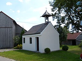
St. Anna in Höllberg
|
|
Höllberg is a district of the Upper Swabian community of Kammlach in the Unterallgäu district in Bavaria . The village, located about two and a half kilometers southwest of Oberkammlach , is connected to Oberkammlach by local roads. The Scheibengraben runs north of the village and the Ratzenbach to the south , both of which are tributaries of the Kammel . A small sewage treatment plant has been installed to the northeast. The landscape around the village is mainly used for agriculture.
history
As early as 1412 Höllberg was mentioned as "Hellberg". Hans Amman from Erisried sold his wood and the meadows, which were called Hellberg, to Ulrich von Teck from Mindelheim . When the rule of Mindelheim was divided in 1431, the wasteland of Höllberg appeared again in the document as "Ainödin Hellberg". Around 1800 the village consisted of nine farms and belonged to the Mindelheim rule. With the Reichsdeputationshauptschluss the place came to Oberkammlach.
In terms of the church, Höllberg belonged to the parish of Mindelheim until 1813, but was given pastoral care from Oberkammlach as early as the 18th century. The chapel of St. Anna was built in the 17th and 18th centuries and has a Mater dolorosa from around 1500 . The chapel was originally dedicated to St. Michael and two bishops.
literature
- Hermann Haisch (Ed.): Landkreis Unterallgäu . Memminger Zeitung Verlagsdruckerei, Memmingen 1987, ISBN 3-9800649-2-1 , p. 1037 .
