
Comb
|
Kammel Kammlach (upper course) |
||
 Mühlkanal near Wettenhausen |
||
| Data | ||
| Water code | EN : 1168 | |
| location | Germany , Bavaria | |
| River system | Danube | |
| Drain over | Mindel → Danube → Black Sea | |
| source | west of Erisried near Stetten (Swabia) 47 ° 59 ′ 48 ″ N , 10 ° 24 ′ 3 ″ E |
|
| Source height | 704 m above sea level NN | |
| muzzle | south of Offingen an der Donau in the Mindel Coordinates: 48 ° 28 '14 " N , 10 ° 22' 42" E 48 ° 28 '14 " N , 10 ° 22' 42" E |
|
| Mouth height | 439 m above sea level NN | |
| Height difference | 265 m | |
| Bottom slope | 4.6 ‰ | |
| length | 57.2 km | |
| Catchment area | 262 km² | |
| Left tributaries | Krumbach (Kammel) | |
| Right tributaries | Haselbach (Kammel) , Krähenbach (Kammel) | |
| Small towns | Krumbach (Swabia) | |
The Kammel , in the upper reaches (up to Krumbach ) also Kammlach , is a 57 km long left tributary of the Mindel . Thus an indirect right tributary of the Danube in Bavaria , Germany . The river is a second-order body of water from the bridge on the MN 8 district road near Unterrieden ( Oberrieden (Swabia) , Unterallgäu district ) to its confluence with the Mindel near Offingen .
Names
The names come from the Celtic, there kamb or camb means something like 'crooked' - so Kammlach is crooked water. Kammel means swamp, which is also appropriate with the countless meanders .
course

The official Kammel spring is located in the Hochfirst forest west of Erisried ( Stetten municipality ) in the Unterallgäu district . Another, longer spring water comes from near Sontheim , east of the Ziegler farmhouse.
After the confluence, it always goes north, through the municipality of Kammlach (which leads the river in the coat of arms) first in a few bends, then from Unterrieden in with many meanders, impact slopes , sliding slopes , bank walls, gravel banks and meadows. Largely natural it flows to Krumbach (in whose coat of arms it can also be found); at Krumbach the Krumbach (usually called Krumbächle ) flows into the Kammel.
The Kammeltal widens north of the confluence of the Krumbächles in the Kammel. From Krumbach to Ettenbeuren (municipality of Kammeltal) the banks are partly still paved, but partly renatured and the Kammel meanders again (especially near Egenhofen , municipality Kammeltal). From Ettenbeuren, a fog on the Kammel is channeled through the Wettenhausen monastery .
Tributaries
In addition to the Krumbächle, which flows into the Kammel in Krumbach, there are two other somewhat larger streams that flow into the Kammel - the Haselbach which flows out at Naichen ( Neuburg an der Kammel ) and the Krähenbach which flows into Ettenbeuren ( Kammeltal ) . For the other, even smaller tributaries of the Kammel, which have a name: → see list of bodies of water in the Mindel river system ;
Localities
The following places (and sights) are located on the Kammel (from the source to the mouth, hence from south to north):
in the Unterallgäu district :
- Kammlach municipality : Ober- and Unterkammlach;
- Municipality of Oberrieden : Ober-, Mittel- and Unterrieden;
- Pfaffenhausen market : Weilbach ;
- Breitenbrunn municipality : Breitenbrunn and Loppenhausen;
in the district of Günzburg :
- Community Aletshausen : Haupeltshofen and Aletshausen;
- City of Krumbach (Swabia) (sights → see article about Krumbach): Niederraunau , Krumbach (Swabia), Billenhausen and Hirschfelden ;
- Markt Neuburg an der Kammel : Erisweiler, Halbertshofen, Neuburg an der Kammel (castle, church, pilgrimage church Maria Feldblume between Neuburg an der Kammel and Wattenweiler), Langenhaslach and Naichen ( Hammerschmiede Naichen );
- Community Kammeltal : Keusch Lingen , Behlingen , Ried , Egenhofen, down tube, Ettenbeuren , Grünhöfe , Reifertsweiler, Wettenhausen ( Wettenhausen Abbey ), Small Beuren and hammer Stetten;
- City of Burgau (sights → see article about Burgau): Nußlachhof, Großanhausen , Ober- and Unterknöringen ;
- Municipality Rettenbach : Remshart (recreation area Silver Lake );

Kammelquelle near Erisried

pent-up comb in Krumbach ( Lower Mill ) and Mühlkapelle
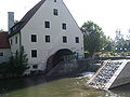
former lower mill in Krumbach, today: House St. Michael
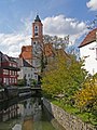
City parish church St. Michael in Krumbach - in the foreground the Kammel


Others
- The regional, 71 km long Kammeltal cycle path runs parallel to the river .
- From Weilbach to Neuburg (Kammel) the Kammeltalbahn runs close to the river.
- No other river in the district of Günzburg has as many river kilometers been renatured as on the Kammel. Between Billenhausen (city of Krumbach (Swabia) ) and Kleinbeuren (municipality of Kammeltal ), the Kammel was brought into a natural state between 1986 and 1993 over a length of 19 km in the sense of ecology and flood prevention. The result of the measures is that the water quality has been improved and the river dynamics have been revived.
Web links
Individual evidence
- ↑ Water body indicators , water length and further information about water bodies in Bavaria at the Bavarian State Office for the Environment ( Memento of the original from April 9, 2005 in the web archive archive.today ) Info: The archive link was automatically inserted and not yet checked. Please check the original and archive link according to the instructions and then remove this notice.
- ↑ a b # 93; = 832 rivers in the district of Günzburg (PDF file with information on the rivers) ( Memento of the original from August 25, 2011 in the Internet Archive ) Info: The archive link was automatically inserted and not yet checked. Please check the original and archive link according to the instructions and then remove this notice.
- ↑ Directory of the waters of the second order in Swabia