
Offingen
| coat of arms | Germany map | |
|---|---|---|

|
Coordinates: 48 ° 29 ' N , 10 ° 22' E |
|
| Basic data | ||
| State : | Bavaria | |
| Administrative region : | Swabia | |
| County : | Gunzburg | |
| Management Community : | Offingen | |
| Height : | 446 m above sea level NHN | |
| Area : | 14.92 km 2 | |
| Residents: | 4312 (Dec. 31, 2019) | |
| Population density : | 289 inhabitants per km 2 | |
| Postal code : | 89362 | |
| Area code : | 08224 | |
| License plate : | GZ, KRU | |
| Community key : | 09 7 74 171 | |
| Market structure: | 4 parts of the community | |
Market administration address : |
Marktstrasse 19 89362 Offingen |
|
| Website : | ||
| Mayor : | Thomas Wörz ( SPD ) | |
| Location of the Offingen market in the Günzburg district | ||
  |
||

Offingen is a market in the Swabian district of Günzburg and the seat of the Offingen administrative community .
geography
Offingen is located in the Donauried between Ulm and Donauwörth on the Danube and Mindel . The Augsburg – Ulm railway crosses the town. The station Neuoffingen was for decades a major Umsteigeknotenpunkt.
The municipality has four officially named municipal parts (the type of settlement is given in brackets ):
- Landstrost ( wasteland )
- Neuoffingen (wasteland)
- Offingen (main town)
- Schnuttenbach ( Kirchdorf )
history
Offingen and Landstrost
Offingen is, as can be derived from the name ending " -ingen ", the founding of an Alemannic clan . The place name is derived from a clan leader Offo . The place emerged as a street village at the intersection of the Roman road from Günzburg to Augsburg with the valley path that runs along the Kammeltal . The place was first mentioned in a document dated September 4, 1186. Pope Urban III. confirmed in it, among other things, the place as property of the Augsburg bishop Udalschalk. The local rule was exercised by Augsburger Ministeriale at that time . One of these ministerials was Konrad Schoberlin, whose gift from 1209 means that another early mention of the place has come down to us.
At the beginning of the 14th century, Offingen and the neighboring Landstrost Castle became part of the Burgau margraviate through an area swap . The place and citizens were then pledged several times to secure monetary claims against creditors . From 1380 the Lords of Westernach in Offingen came into possession of such pledges and in some cases also fiefdoms . In 1518 Eustachius von Westernach sold his fiefdom and pledge property to the Lords of Stain zu Rechtenstein in Reisensburg . Around 1550 they got into an economic emergency and in 1599 sold the Offingen property to the Lords of Schellenberg zu Hüfingen. But these also became indebted with the property and ceded the feudal estates back to the barons of Freyberg-Eisenberg in Haldenwang as early as 1659 , who held local rule until the feudal rights were replaced in the 19th century.


During the Peasants' War in 1525, there were no major incidents in Offingen. Rather, the Offingen farmers seemed to have held back, since in March 1525 the Leipheimer Haufen moved to Offingen in order to "force Offingen farmers into its union". After the peasant uprising was put down, only two ringleaders from Offingen were punished; the place got away with a fine. Little is known of Offingen from the Thirty Years' War from 1618 to 1648. A tax register from 1627 mentions numerous wealthy people in the area. Until 1680 there was no record of the general development of the place.
From 1696 to 1700 a new castle was built in Landstrost by the barons of Freyberg. Around 1748 a castle (today's rectory) was built in Offingen.
Offingen had the status of an upper bailiff around 1800. The place has belonged to Bavaria since 1806. The trigger was the Rhine Confederation Act , an alliance of southern German states with France's Emperor Napoléon Bonaparte . This agreement determined, among other things, that the noble principalities as well as the knightly possessions, which were previously imperial direct, were subordinated to the respective sovereign ( mediatization ).
The castle in Offingen was inhabited by the Barons von Freyberg until 1858 and then sold for lack of further use. After the farmer Johann Haupeltshofer became the new lord of the castle in 1862, the community and the church foundation acquired the property in 1878 and used it as a school and parsonage. The castle in Landstrost was badly damaged by several landslides in 1871 and finally demolished in 1872.
After the Second World War , the community took in around 1,000 displaced persons . In the neighboring Schnuttenbach , today part of the municipality of Offingen, around 75 Hungarian Germans and around 250 evacuated people from the Sudetenland were housed in a barrack camp .
Incorporations
The Schnuttenbach community was incorporated into Offingen on May 1, 1978. At the same time, the newly established administrative community of Offingen, Gundremmingen and Rettenbach began its work, which is located in the new Offingen town hall.
Population development
Between 1988 and 2018 the market grew from 3,374 to 4,231 by 857 inhabitants or by 25.4%.
Part of the municipality Schnuttenbach
The place was first mentioned in a document in 1298. Its special gem is the Saint Ursula Chapel. It is decorated with frescoes from the 12th century. The attached St. Ursula Church has artistically remarkable glass windows by Munich professor Josef Oberberger .
Schnuttenbach was the location of a labor camp during the time of National Socialism. The documentary film Verborgen in Schnuttenbach by Thomas Gerhard Majewski is dedicated to this camp.
politics
Mayor Thomas Wörz ( SPD ) has been in office since the local elections in 2008 . He was re-elected in March 2014 with 57.3% of the votes and confirmed in office for a further six years on March 15, 2020 with 81.0% of the votes.
The municipal council has 16 members. In the election on March 15, 2020 , the distribution of seats was as follows:
- CSU : 4 seats (25.6%)
- Free voters Offingen : 4 seats (22.9%)
- SPD: 3 seats (20.9%)
- Young citizens Offingen: 2 seats (11.0%)
- Free voter association Schnuttenbach: 2 seats (9.5%)
- Alliance 90 / The Greens : 1 seat (8.1%)
The left did not get a seat (2.0%).
In the 2014 to 2020 term of office, the seats were distributed as follows:
- CSU: 5 seats
- SPD: 5 seats
- Free voters Offingen: 4 seats
- Free voter association Schnuttenbach: 1 seat
- Young citizens: 1 seat
education
- Day care center St. Georg Offingen (1 day nursery group, 4 kindergarten groups)
- Kinderhaus St. Ursula Schnuttenbach (1 crèche group, 2 kindergarten groups)
- Offingen primary school
- Middle School Offingen
- Branch of Volkshochschule Günzburg
Attractions

- The castle in Offingen was built around 1748 as a mansion for the Barons von Freyberg. The building originally housed the patrimonial court . After the mediatization of the principalities and the abolition of feudal jurisdiction in 1848, the building changed hands several times before half of it came into the possession of the community and the church foundation in 1879 and served as a school and rectory. The stork's nest on the building known today as the vicarage is populated by storks that have been wintering in the nest for several years.
- The Catholic parish church of St. Georg was built from 1615 to 1618 on a foundation by Hans Christoph von Schellenberg and his wife Dorothea on the site of an older predecessor building. The donor's coat of arms is preserved in the choir vault. The late Renaissance style pulpit probably comes from the original furnishings of the church. The main altar in the choir dates from the Rococo period , the side altars were put together in their current form during a renovation in 1958.
- The Leonhard Chapel was built at the instigation of the Lords of Freyberg in 1747 in place of an older chapel consecrated to Leonhard.
- The Warrior Memorial Chapel was built in 1954 according to plans by Eduard Haertinger.
- The Protestant Reconciliation Church was built in 1965. A Protestant community only formed in Offingen with industrialization in the second half of the 19th century and only reached a significant size after the arrival of evangelical expellees after the Second World War.
- The Barbarakapelle is located near Landstrost, and there is also a Trinity chapel from the 18th century on Kapellenweg after Landstrost .
- Since May 2006, the 25-meter-high observation tower on the edge of the slope facing the Danube valley has offered a panoramic view, especially of the Danube valley and the Swabian Alb.

St. George Church
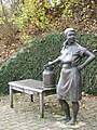
Monument to the dairy farmer
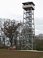
Danube valley observation tower

Modern court cross


economy
Offingen was a largely rural community until the middle of the 20th century. The bronze monument of the dairy farmer reminds us that the village allowed over 100 dairy farmers to make a living.
The Augsburg entrepreneurs Johannes and Wilhelm Lembert and Franz Baptist Silbermann set up the felt factory in 1896 . It developed into the economically strongest company in the area. The BWF Group that emerged from it has worldwide business contacts in the 21st century and has subsidiaries in several countries. Industrial settlements such as the paper factory, the artificial fertilizer factory or a furniture factory lost their importance after a temporary heyday.
Two markets have been held in Offingen every year since 1950. On July 14, 1971, the Bavarian State Government therefore gave the place the official name of Markt. The Offingen market should not be confused with Marktoffingen , which is about 50 km further north.
traffic

The Offingen stop is on the Augsburg – Ulm railway line . The official commissioning of this railway line from May 1, 1854 promoted passenger and freight traffic. The express mail car connection from Dillingen an der Donau was shortly afterwards led to Offingen train station via Lauingen and Gundremmingen instead of Günzburg .
By a Bavarian law of April 29, 1869, the construction of a railway connection between Günzburg an der Donau and Donauwörth, the upper Danube Valley Railway , was commissioned. The Neuoffingen branching station was built between Günzburg and Offingen . On August 15, 1876, rail traffic was officially started on the new route. Passenger trains stopped there until 1988. Neuoffingen is one of the last brick railway stations in Bavaria under monument protection .
Offingen is connected to a number of long-distance cycle paths, including the Danube cycle path (runs from the source to the mouth of the Danube) and within the European EuroVelo network to the long-distance cycle path Flusseroute EV 6 (runs from the Atlantic to the Black Sea for more than 6000 km along six European rivers).
Personalities
- Hans Müller-Schnuttenbach (* 1889 in Munich , † 1973 in Rosenheim ), painter and draftsman of Upper Bavarian landscapes
- Ferdinand Rohrhirsch (* 1957 in Offingen; † 2018 in Esslingen am Neckar ), philosopher, theologian and executive coach
literature
- Paul Auer: On the history of Offingen , in: Das Obere Schwaben, Episode 2, 1956
- FX Hieber: Offingen then and now , market town of Offingen, 1971
- Dr. Helmut Offermann u. Andreas Thoma: Offingen 800 years 1186–1986 , market town Offingen, 1986
- Offingen - Pictures from bygone days , Horb a. Neckar, 1992
- Robert Hieber: Die Donau , Marktgemeinde Offingen, 2009 ( Our Offingen , issue 1)
- Robert Hieber: The 19th Century , Market Town Offingen, 2010 ( Our Offingen , Book 2)
- Robert Hieber: Difficult years , market town Offingen, 2011 ( Our Offingen , issue 3)
- Robert Hieber: Wirtshausgeschichte / n , Marktgemeinde Offingen, 2013 ( Our Offingen , issue 4)
- Robert Hieber: trade, craft, trade, industry , market town of Offingen, 2016 ( Our Offingen , issue 5)
Web links
- Website Markt Offingen / Donau
- Entry on the coat of arms of Offingen in the database of the House of Bavarian History
Individual evidence
- ↑ "Data 2" sheet, Statistical Report A1200C 202041 Population of the municipalities, districts and administrative districts 1st quarter 2020 (population based on the 2011 census) ( help ).
- ^ Donauried communities
- ^ Community Offingen in the local database of the Bavarian State Library Online . Bavarian State Library, accessed on August 28, 2019.
- ^ Federal Statistical Office (ed.): Historical municipality directory for the Federal Republic of Germany. Name, border and key number changes in municipalities, counties and administrative districts from May 27, 1970 to December 31, 1982 . W. Kohlhammer, Stuttgart / Mainz 1983, ISBN 3-17-003263-1 , p. 775 .
- ↑ Statistics
- ^ History of the parish church of St. Georg
- ↑ https://www.augsburger-allgemeine.de/guenzburg/In-Offingen-haben-ein-aussergewoehnliches-Kreuz-id55438436.html
- ↑ Danube Cycle Path. .
- ↑ EuroVelo 6: explore the European rivers by bike! - EuroVelo. .

Aichen | Aletshausen | Balzhausen | Bibertal | Breitenthal | Bubesheim | Burgau | Burtenbach | Deisenhausen | Dürrlauingen | Ebershausen | Ellzee | Gundremmingen | Gunzburg | Haldenwang | Ichenhausen | Jettingen-Scheppach | Kammeltal | Kötz | Krumbach (Swabia) | Landensberg | Leipheim | Münsterhausen | Neuburg an der Kammel | Offingen | Rettenbach | Röfingen | Thannhausen | Ursberg | Waldstetten | Waltenhausen | Wiesenbach | Winterbach | Ziemetshausen
Unregulated areas: Ebershauser-Nattenhauser Wald | Vintner forest