
Breitenthal (Swabia)
| coat of arms | Germany map | |
|---|---|---|

|
Coordinates: 48 ° 14 ' N , 10 ° 18' E |
|
| Basic data | ||
| State : | Bavaria | |
| Administrative region : | Swabia | |
| County : | Gunzburg | |
| Management Community : | Krumbach (Swabia) | |
| Height : | 528 m above sea level NHN | |
| Area : | 13.27 km 2 | |
| Residents: | 1244 (Dec. 31, 2019) | |
| Population density : | 94 inhabitants per km 2 | |
| Postal code : | 86488 | |
| Area code : | 08282 | |
| License plate : | GZ, KRU | |
| Community key : | 09 7 74 117 | |
| Community structure: | 3 parts of the community | |
| Association administration address: | Rittlen 6 86381 Krumbach (Swabia) |
|
| Website : | ||
| First Mayor : | Gabriele Wohlhöfler (Free Association of Voters) | |
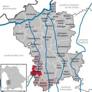
| Location of the community Breitenthal in the district of Günzburg | ||
  |
||


Breitenthal is a municipality in the Swabian district of Günzburg and a member of the administrative association Krumbach (Swabia) .
geography
The municipality is located in the Donau-Iller region.
There are three officially named parts of the municipality (the type of settlement is given in brackets ):
- Breitenthal ( parish village )
- Nattenhausen (parish village)
- Oberried ( Kirchdorf )
The districts Breitenthal and Nattenhausen exist .
history
Until the churches are founded
Breitenthal was mentioned for the first time in 1105 as a foundation property of the Reichsstift Kloster Roggenburg . Nattenhausen belonged to the margraviate of Burgau until 1492 and became part of the Augsburg bishopric in the 16th century . Since the Reichsdeputationshauptschluss of 1803 the place belongs to Bavaria. In the course of the administrative reforms in Bavaria , the municipal edict of 1818 created the municipalities of Breitenthal and Nattenhausen.
Incorporations
On May 1, 1978, the previously independent community of Nattenhausen was incorporated.
Population development
- 1961: 945 inhabitants
- 1970: 995 inhabitants
- 1987: 954 inhabitants
- 1991: 1064 inhabitants
- 1995: 1156 inhabitants
- 2000: 1221 inhabitants
- 2005: 1284 inhabitants
- 2010: 1220 inhabitants
- 2015: 1220 inhabitants
- 2018: 1223 inhabitants
- 2019: 1244 inhabitants (as of December 31, 2019)
Between 1988 and 2019 the municipality grew from 1,004 to 1,244 by 240 inhabitants or 23.9%.
politics
The municipal council has twelve members. In the local elections on March 15, 2020 , the Breitenthal Free Voting Community had seven seats (58.3%); the Nattenhausen Free Voting Community had five seats (41.7%).
The mayor is Gabriele Wohlhöfler (* 1963) (Free Association of Voters). In 2002 she succeeded Urban Lecheler (Free Voting Association). In the local elections on March 15, 2020, she was confirmed in office for another six years with 84.8% of the vote.
A third mayor was elected for the first time at the constituent meeting on May 11, 2020. After a long term in office, Reiner Stohr hands over the office of second mayor to Günter Klughammer, who was unanimously elected. The third mayor is Thomas Burghard.
coat of arms
|
|
Blazon : "Above a green three-mountain split by red and silver, in front three golden ears of rye, behind a blue wavy bar" |
Culture and sights

- Catholic parish church Heilig Kreuz, built in 1785/1786 under the Roggenburg abbot Gilbert Scheyerle according to plans by Joseph Dossenberger , with baroque furnishings and ceiling frescoes by the Swabian baroque painter Konrad Huber
- Rectory
- Oberrieder Weiher , largest quarry pond in Bavarian Swabia
Economy and Infrastructure
Economy including agriculture and forestry
In 1998, according to official statistics, there were no employees at the place of work in the manufacturing sector 63 or in the trade and transport sector. In other economic sectors 31 people were employed at the place of work subject to social security contributions. There were a total of 392 employees at the place of residence subject to social security contributions. There were four companies in the manufacturing sector and five in the construction sector. In addition, there were 42 agricultural holdings in 1999 with an agricultural area of 722 ha, of which 416 ha were arable land.
education
The following institutions exist in 2020:
- A community kindergarten with two groups
Personalities
- Karl Ganser (* 1937), geographer and city planner
- Robert Naegele (1925–2016), actor, writer and radio play author
Web links
- Breitenthal community
- Citizen and Council Information System
- Homepage of the parish community Breitenthal
- Breitenthal (Schwaben): Official statistics of the LfStat
Individual evidence
- ↑ "Data 2" sheet, Statistical Report A1200C 202041 Population of the municipalities, districts and administrative districts 1st quarter 2020 (population based on the 2011 census) ( help ).
- ^ First mayor Breitenthal. Verwaltungsgemeinschaft Krumbach, accessed on May 31, 2020 .
- ^ Community Breitenthal in the local database of the Bavarian State Library Online . Bayerische Staatsbibliothek, accessed on August 30, 2019.
- ↑ a b c Federal Statistical Office (ed.): Historical municipality directory for the Federal Republic of Germany. Name, border and key number changes in municipalities, counties and administrative districts from May 27, 1970 to December 31, 1982 . W. Kohlhammer, Stuttgart / Mainz 1983, ISBN 3-17-003263-1 , p. 775 .
- ↑ Breitenthal compact in numbers - administrative community Krumbach. Retrieved July 10, 2020 .
- ↑ https://www.wahlen.bayern.de/kommunalwahlen/
- ^ Augsburger Allgemeine: Breitenthal has a third mayor for the first time. Retrieved May 18, 2020 .
- ^ Breitenthal municipal council (Breitenthal). Retrieved May 17, 2020 .
- ^ Entry on the coat of arms of Breitenthal (Swabia) in the database of the House of Bavarian History

Aichen | Aletshausen | Balzhausen | Bibertal | Breitenthal | Bubesheim | Burgau | Burtenbach | Deisenhausen | Dürrlauingen | Ebershausen | Ellzee | Gundremmingen | Gunzburg | Haldenwang | Ichenhausen | Jettingen-Scheppach | Kammeltal | Kötz | Krumbach (Swabia) | Landensberg | Leipheim | Münsterhausen | Neuburg an der Kammel | Offingen | Rettenbach | Röfingen | Thannhausen | Ursberg | Waldstetten | Waltenhausen | Wiesenbach | Winterbach | Ziemetshausen
Unregulated areas: Ebershauser-Nattenhauser Wald | Vintner forest