
Wiesenbach (Swabia)
| coat of arms | Germany map | |
|---|---|---|

|
Coordinates: 48 ° 18 ' N , 10 ° 18' E |
|
| Basic data | ||
| State : | Bavaria | |
| Administrative region : | Swabia | |
| County : | Gunzburg | |
| Management Community : | Krumbach (Swabia) | |
| Height : | 500 m above sea level NHN | |
| Area : | 11.47 km 2 | |
| Residents: | 994 (Dec. 31, 2019) | |
| Population density : | 87 inhabitants per km 2 | |
| Postal code : | 86519 | |
| Area code : | 08283 | |
| License plate : | GZ, KRU | |
| Community key : | 09 7 74 189 | |
| Community structure: | 4 parts of the community | |
| Association administration address: | Rittlen 6 86381 Krumbach (Swabia) |
|
| Website : | ||
| Mayor : | Gilbert Edelmann (voter groups) | |
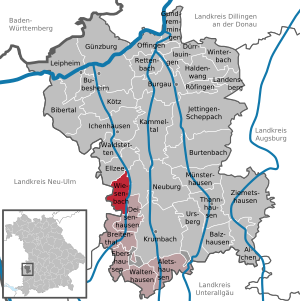
| Location of the municipality of Wiesenbach in the district of Günzburg | ||
  |
||


Wiesenbach is a municipality in the Swabian district of Günzburg and a member of the administrative community Krumbach (Swabia) .
geography
Wiesenbach is located in the Donau-Iller region.
The municipality consists of three districts and has four officially named municipality parts (the type of place is given in brackets ):
- Oberegg ( village )
- Oberwiesenbach ( parish village )
- Unterwiesenbach ( Kirchdorf ) with Sausenthal (village)
history
Until the church is planted
The local nobility of the Wiesenbacher sold their property in 1398 to the Counts of Kirchberg. In 1447 Wiesenbach came to the Reichsstift Kloster Roggenburg . Since the Reichsdeputationshauptschluss of 1803 the place belongs to Bavaria. In the course of the administrative reforms in Bavaria , the municipal edict of 1818 created the municipalities of Oberwiesenbach and Unterwiesenbach.
Incorporations
On May 1, 1978, the previously independent communities Oberegg and Oberwiesenbach were incorporated into the community Unterwiesenbach.
Name change
On October 31, 1978, half a year after the municipality reform , the name of the municipality Unterwiesenbach was officially changed to Wiesenbach .
Population development
- 1840: 791 inhabitants
- 1900: 728 inhabitants
- 1939: 801 inhabitants
- 1950: 1230 inhabitants
- 1961: 870 inhabitants
- 1970: 841 inhabitants
- 1987: 845 inhabitants
- 1991: 897 inhabitants
- 1995: 904 inhabitants
- 2000: 907 inhabitants
- 2005: 972 inhabitants
- 2010: 994 inhabitants
- 2015: 963 inhabitants
Between 1988 and 2018, the community grew from 863 to 983 by 120 inhabitants or 13.9%.
politics
The municipal council has eight members. In the 2020 local elections , the Free Voters Wiesenbach (FWW, 54.6%) and the Independent Voters Wiesenbach (UWW, 45.4%) each had four seats.
Gilbert Edelmann has been the mayor since May 1, 2020, jointly nominated by the Free Voters Community and Independent Voters and elected on March 15, 2020 with 95.5% of the votes.
Mayors since the completion of the municipal reform have been:
- 1978–1982: Anton Müller
- 1982–1983: Ludwig Negele provisionally until the election
- 1983–1984: Blasius Müller
- 1984–2002: Fritz Birle (Free Voting Group)
- 2002–2020: Ilse Thanopoulos (Free Voter Groups)
Architectural monuments
Economy including agriculture and forestry
In 1998, according to official statistics, there were 79 employees at the place of work in the manufacturing sector and nine in the trade and transport sector. There were a total of 330 employees at the place of residence subject to social security contributions. There was one company in the manufacturing sector and one in the main construction sector. In addition, in 1999 there were 41 farms with an agricultural area of 814 hectares, 410 hectares of which were arable land and 404 hectares of permanent green area.
Sons and daughters of the church
- Eugen Wohlhaupter (1900–1946), born in Unterwiesenbach, German legal historian
- Josef Spies (1906–1985), born in Oberwiesenbach, politician (CSU), member of the Bundestag
Web links
- Entry on the coat of arms of Wiesenbach (Swabia) in the database of the House of Bavarian History
Individual evidence
- ↑ "Data 2" sheet, Statistical Report A1200C 202041 Population of the municipalities, districts and administrative districts 1st quarter 2020 (population based on the 2011 census) ( help ).
- ^ Community Wiesenbach in the local database of the Bavarian State Library Online . Bavarian State Library, accessed on August 22, 2019.
- ↑ a b c d Federal Statistical Office (Hrsg.): Historical municipality register for the Federal Republic of Germany. Name, border and key number changes in municipalities, counties and administrative districts from May 27, 1970 to December 31, 1982 . W. Kohlhammer, Stuttgart / Mainz 1983, ISBN 3-17-003263-1 , p. 775 .
- ↑ Archived copy ( memento of the original from March 4, 2017 in the Internet Archive ) Info: The archive link was inserted automatically and has not yet been checked. Please check the original and archive link according to the instructions and then remove this notice.

Aichen | Aletshausen | Balzhausen | Bibertal | Breitenthal | Bubesheim | Burgau | Burtenbach | Deisenhausen | Dürrlauingen | Ebershausen | Ellzee | Gundremmingen | Gunzburg | Haldenwang | Ichenhausen | Jettingen-Scheppach | Kammeltal | Kötz | Krumbach (Swabia) | Landensberg | Leipheim | Münsterhausen | Neuburg an der Kammel | Offingen | Rettenbach | Röfingen | Thannhausen | Ursberg | Waldstetten | Waltenhausen | Wiesenbach | Winterbach | Ziemetshausen
Unregulated areas: Ebershauser-Nattenhauser Wald | Vintner forest