
Aichen
| coat of arms | Germany map | |
|---|---|---|

|
Coordinates: 48 ° 14 ' N , 10 ° 33' E |
|
| Basic data | ||
| State : | Bavaria | |
| Administrative region : | Swabia | |
| County : | Gunzburg | |
| Management Community : | Ziemetshausen | |
| Height : | 510 m above sea level NHN | |
| Area : | 17.61 km 2 | |
| Residents: | 1141 (Dec. 31, 2019) | |
| Population density : | 65 inhabitants per km 2 | |
| Postal code : | 86479 | |
| Primaries : | 08284, 08262 | |
| License plate : | GZ, KRU | |
| Community key : | 09 7 74 166 | |
| LOCODE : | DE ACN | |
| Community structure: | 6 parts of the community | |
| Address of the municipal administration: |
Wiesweg 1 86479 Aichen |
|
| Website : | ||
| Mayor : | Alois Kling, Mayor ( CSU / independence. Wbl. / Fr.Wählersch. ) | |
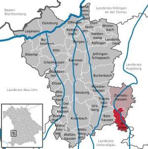
| Location of the municipality of Aichen in the district of Günzburg | ||
  |
||


Aichen is a municipality in the Swabian district of Günzburg and a member of the Ziemetshausen administrative community .
geography
The municipality is located in the Donau-Iller region.
The municipality has six officially named municipality parts (the type of settlement is given in brackets ):
- Aichen ( parish village )
- Bernbach ( hamlet )
- Memmenhausen (parish village)
- Nachstetten (hamlet)
- Obergessertshausen (parish village)
- Ruhfelden ( village )

history
Until the church is planted
Aichen belonged to St. Moritz Abbey in the Free Imperial City of Augsburg from 1660 . Since the peace treaties of Brno and Pressburg in 1805, the place has belonged to the newly formed Kingdom of Bavaria . In the course of the administrative reforms in the Kingdom of Bavaria, today's municipality was created with the municipal edict of 1818 .
Parish name
In 1865 the community Gessertshausen was officially renamed Obergessertshausen . The new community created on January 1, 1976 from the merger of Memmenhausen and Obergessertshausen was given the name Aichen.
Incorporations
On January 1, 1972, the previously independent municipality of Aichen was incorporated into Obergessertshausen. On January 1st, 1976 Memmenhausen and Obergessertshausen merged to form the new municipality of Aichen.
Population development
- 1961: 1120 inhabitants
- 1970: 1126 inhabitants
- 1987: 1063 inhabitants
- 1991: 1128 inhabitants
- 1995: 1119 inhabitants
- 2000: 1160 inhabitants
- 2005: 1171 inhabitants
- 2010: 1164 inhabitants
- 2015: 1130 inhabitants
Between 1988 and 2018 the municipality grew from 1,091 to 1,154 by 63 inhabitants or 5.8%.
politics
City council and mayor
The municipal council has twelve members. Since the 2014 local elections, the seats have been divided into the following lists:
- Free electorate Obergessertshausen: 5 seats
- CSU / Independent voter bloc Memmenhausen: 4 seats, including 1 woman
- Aichen free electorate: 3 seats
Alois Kling (CSU / UWB / FWS) has been mayor since 1996; he was confirmed in office for a further six years on March 15, 2020 with 85.2% of the vote.
coat of arms
Under a golden shield head, inside a green acorn with three green oak leaves, split, front five times obliquely left divided by silver and red, topped with a gold post, behind in red a silver side rafter.
Architectural monuments and ground monuments
- Catholic parish church of St. Ulrich
Economy and Infrastructure
Economy including agriculture and forestry
In 1998 there were no employees at the place of work in agriculture and forestry, 23 in manufacturing and no employees in trade and transport. In other economic sectors, twelve people were employed at the place of work subject to social security contributions. There were a total of 406 employees at the place of residence subject to social security contributions. There were no companies in the manufacturing or construction industry. In 1999 there were 52 farms with an agriculturally used area of 1030 hectares. 334 hectares of this were arable land and 696 hectares were permanent green areas.
education
The following institutions exist (as of: 1999):
- Kindergarten: 25 kindergarten places with 25 children
sons and daughters of the town
- Leonhard Bobinger (1876–1962), Catholic clergyman
- Berta Schmid (* 1951), Member of the Bavarian State Parliament (CSU)
See also
Web links
- Homepage
- Entry on the coat of arms of Aichen in the database of the House of Bavarian History
Individual evidence
- ↑ "Data 2" sheet, Statistical Report A1200C 202041 Population of the municipalities, districts and administrative districts 1st quarter 2020 (population based on the 2011 census) ( help ).
- ^ Ziemetshausen administrative community : Aichen municipality: 1. Bgm. Alois Kling. Retrieved May 9, 2020 .
- ^ Aichen community in the local database of the Bavarian State Library Online . Bayerische Staatsbibliothek, accessed on August 30, 2019.
- ↑ a b Wilhelm Volkert (Ed.): Handbook of the Bavarian offices, communities and courts 1799–1980 . CH Beck, Munich 1983, ISBN 3-406-09669-7 , p. 501 .
- ↑ a b c d Federal Statistical Office (Hrsg.): Historical municipality register for the Federal Republic of Germany. Name, border and key number changes in municipalities, counties and administrative districts from May 27, 1970 to December 31, 1982 . W. Kohlhammer, Stuttgart / Mainz 1983, ISBN 3-17-003263-1 , p. 774 .

Aichen | Aletshausen | Balzhausen | Bibertal | Breitenthal | Bubesheim | Burgau | Burtenbach | Deisenhausen | Dürrlauingen | Ebershausen | Ellzee | Gundremmingen | Gunzburg | Haldenwang | Ichenhausen | Jettingen-Scheppach | Kammeltal | Kötz | Krumbach (Swabia) | Landensberg | Leipheim | Münsterhausen | Neuburg an der Kammel | Offingen | Rettenbach | Röfingen | Thannhausen | Ursberg | Waldstetten | Waltenhausen | Wiesenbach | Winterbach | Ziemetshausen
Unregulated areas: Ebershauser-Nattenhauser Wald | Vintner forest