Winterbach (Swabia)
| coat of arms | Germany map | |
|---|---|---|

|
Coordinates: 48 ° 28 ' N , 10 ° 29' E |
|
| Basic data | ||
| State : | Bavaria | |
| Administrative region : | Swabia | |
| County : | Gunzburg | |
| Management Community : | Haldenwang | |
| Height : | 462 m above sea level NHN | |
| Area : | 14.84 km 2 | |
| Residents: | 739 (Dec. 31, 2019) | |
| Population density : | 50 inhabitants per km 2 | |
| Postal code : | 89368 | |
| Area code : | 08283 | |
| License plate : | GZ, KRU | |
| Community key : | 09 7 74 196 | |
| Community structure: | 6 parts of the community | |
| Association administration address: | Hauptstrasse 28 89356 Haldenwang |
|
| Website : | ||
| Mayor : | Reinhard Schieferle (non-partisan) | |
| Location of the municipality of Winterbach in the district of Günzburg | ||
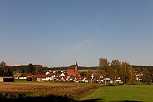
Winterbach is a municipality in the Swabian district of Günzburg and a member of the Haldenwang administrative community .
geography
location
Winterbach is located in the Donau-Iller region in the northeastern part of the Günzburg district in the Holzwinkel in the Augsburg-Westliche Wälder nature park . The municipality is traversed from south to north by the Glött , which runs from the west on the edge of the eponymous capital of the municipality of Wallerbach and at the village of Waldkirch the Flosserlohbach . The open communal corridor on both sides of the river valley is framed in the west and especially in the east by larger forest areas. The with about 514 m above sea level. NHN highest point in the municipality is in the forest at its southeast corner, the lowest at the outflow of the Glött in the north at about 411 m above sea level. NHN .
Parish parts
The municipality has 6 officially named municipality parts (the type of location is given in brackets ):
- Delkenmühle ( wasteland )
- Eisingerhof (wasteland)
- Rechbergreuthen ( Kirchdorf )
- Waldkirch (Kirchdorf)
- Waldkircher Mühle (wasteland)
- Winterbach ( parish village )
geology
The upper freshwater molasses are to be found in the majority of the municipal area , the greater heights around it are covered by older gravel that was deposited up until the Günz Glaciation . At the very eastern edge there is still a loess derivative from younger Aeolian sedimentation .
history
Until the founding of the forerunner churches
Winterbach was first mentioned in the 11th century and belonged to Count Fugger-Glött as part of the Glött rule . With the Rhine Confederation Act in 1806, the area became part of the Kingdom of Bavaria . The three Holzwinkeldörfer Winterbach, Waldkirch and Rechbergreuthen became independent municipalities through the Bavarian municipal edict of 1818.
fusion
Today's Winterbach municipality was created on July 1, 1972 through a voluntary amalgamation of the Rechbergreuthen, Waldkirch and Winterbach municipalities.
Population development
- 1961: 808 inhabitants, of which 236 in Rechbergreuthen, 292 in Waldkirch and 280 in Winterbach
- 1970: 778 inhabitants, 198 of them in Rechbergreuthen, 293 in Waldkirch and 287 in Winterbach
- 1987: 653 inhabitants
- 1991: 750 inhabitants
- 1995: 780 inhabitants
- 2000: 781 inhabitants
- 2005: 807 inhabitants
- 2010: 826 inhabitants
- 2015: 759 inhabitants
Between 1988 and 2018, the community grew from 687 to 734 by 47 inhabitants or 6.8%.
religion
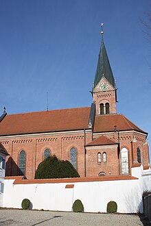
The Catholic parish church of St. Gordian and Epimach, built in 1888, is in Winterbach, the Catholic parish church of St. Nikolaus in Rechbergreuthen and the Catholic parish and pilgrimage church of Mary Pain in Waldkirch .
politics
The municipal council has eight members. In the local elections on March 15, 2020 , these were distributed across the following lists - unchanged from the 2014 to 2020 term of office:
- Waldkirch voter association: 3 seats (40.5%)
- Voter association Winterbach: 3 seats (36.7%)
- Voters' association Rechbergreuthen: 2 seats (22.8%)
Mayor has been Reinhard Schieferle since May 1, 2020; it was nominated by all three local electoral groups and received 97.7% of the vote. Its predecessors were
- Karl Oberschmid (Waldkirch Voters' Association) from 2008 to 2020.
- Josef Schieferle from October 1980 to April 2008.
Soil monuments
There are some archaeological monuments in the municipality . The oldest two come from prehistory and are located on the northern border of the municipality: a cremation grave field from the urn burial time north of Waldkirch and a burial mound on the edge of the forest east of the Eisingerhof. West of Waldkirch there was a settlement in the Flosserlohtal during the Roman Empire. From the Middle Ages , there is a large castle stables with preserved wall remnants east of Winterbach in the forest and a smaller one in the village area north of the church. Further finds were made in the local area of Waldkirch and Rechbergreuthen.
See also: List of soil monuments in Winterbach (Swabia)
Economy and education
economy
In 1998, according to official statistics , there were no employees at the place of work in the manufacturing industry or in the trade and transport sector. In other economic areas, 16 people were employed at the place of work subject to social security contributions. There were a total of 231 employees at the place of residence subject to social security contributions . There were no companies in the manufacturing or construction industries. In 1999 there were 29 farms with an agriculturally used area of 617 ha, of which 427 ha were arable land and 190 ha were permanent green space.
education
A kindergarten has existed in the former schoolhouse in the Winterbach community since 1990 .
See also
Web links
- Entry on the coat of arms of Winterbach (Swabia) in the database of the House of Bavarian History
- Winterbach (Swabia): Official statistics of the LfStat
- Map of the municipality of Winterbach on: BayernAtlas of the Bavarian State Government ( information )
Individual evidence
BayernAtlas ("BA")
Official online waterway map with a suitable section and the layers used here: Municipality of Winterbach
General introduction without default settings and layers: BayernAtlas of the Bavarian State Government ( notes )
- ↑ Height queried on the BayernAtlas (right click).
- ↑ Geology according to the geological map 1: 500,000 on the BayernAtlas.
- ↑ Archaeological monuments after the layer of the same name.
Other
- ↑ "Data 2" sheet, Statistical Report A1200C 202041 Population of the municipalities, districts and administrative districts 1st quarter 2020 (population based on the 2011 census) ( help ).
- ^ Winterbach municipality in the local database of the Bavarian State Library Online . Bavarian State Library, accessed on August 22, 2019.
- ^ Wilhelm Volkert (ed.): Handbook of Bavarian offices, communities and courts 1799–1980 . CH Beck, Munich 1983, ISBN 3-406-09669-7 , p. 476 .
- ↑ http://www.augsburger-allgemeine.de/guenzburg/Auf-seinem-Weg-hat-er-grosse-Spuren-hinterendung-id3922616.html
- ↑ Website of the Winterbach municipality , winterbach.bnv-gz.de, accessed on March 19, 2017, (sub-item education ).


