Hirschfelden (Krumbach)
|
Hirschfelden
City of Krumbach (Swabia)
Coordinates: 48 ° 17 ′ 13 ″ N , 10 ° 21 ′ 49 ″ E
|
|
|---|---|
| Height : | 498 m above sea level NN |
| Postal code : | 86381 |
| Area code : | 08283 |
|
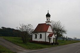
Chapel of St. Maria in Hirschfelden
|
|
Hirschfelden is a district of Krumbach (Swabia) . The hamlet is about 4.5 km north of Krumbach and 1.5 km north of Billenhausen in the Kammeltal on the state road St 2024 leading from Krumbach through the Kammeltal to Offingen . In addition, Hirsch Felden has on the northern outskirts a breakpoint that of Mindelheim to Gunzburg leading Mittelschwaben track that holds approximately hourly Hirsch Felden.
history
On January 1, 1972, the previously independent community of Billenhausen , to which Hirschfelden belonged, came to the city of Krumbach as part of the regional reform .
Attractions
- Marienkapelle , built in 1731, with a statue of Mary from 1613, which is attributed to Christoph Rodt
Others
About 400 m east of Hirschfelden there is a castle stable in the forest on the slope of the Schloßberg , which slopes down towards the Kammeltal . It is not known when this castle was built and then demolished.
See also
Web links
Individual evidence
- ^ Page about the Billenhausen district on www.krumbach.de
- ↑ Ullmann, FG, (photos: Huber, M. & Huber, M.) 1992: Krumbach - Images from the city and the countryside in Central Swabia. - Müller Druck und Verlag, Krumbach, 157 pp.
- ↑ Page about the castles and palaces in the district of Günzburg at “burgeninventar.de” ( memento of the original from April 19, 2009 in the Internet Archive ) Info: The archive link was automatically inserted and not yet checked. Please check the original and archive link according to the instructions and then remove this notice.
