
Kammlach
| coat of arms | Germany map | |
|---|---|---|

|
Coordinates: 48 ° 3 ' N , 10 ° 25' E |
|
| Basic data | ||
| State : | Bavaria | |
| Administrative region : | Swabia | |
| County : | Unterallgäu | |
| Management Community : | Erkheim | |
| Height : | 600 m above sea level NHN | |
| Area : | 26.72 km 2 | |
| Residents: | 1837 (Dec. 31, 2019) | |
| Population density : | 69 inhabitants per km 2 | |
| Postal code : | 87754 | |
| Area code : | 08261 | |
| License plate : | MN | |
| Community key : | 09 7 78 180 | |
| LOCODE : | DE KML | |
| Community structure: | 10 parish parts | |
| Association administration address: | Marktstrasse 1 87746 Erkheim |
|
| Website : | ||
| Mayoress : | Birgit Steudter-Adl Amini ( community of voters ) | |
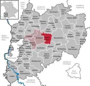
| Location of the municipality of Kammlach in the Unterallgäu district | ||
  |
||


Kammlach is a municipality in the Swabian district of Unterallgäu and a member of the Erkheim administrative community .
geography
Kammlach is located about 25 kilometers east of Memmingen in the Donau-Iller region in Central Swabia .
Expansion of the municipal area
The municipality consists of the districts Oberkammlach and Unterkammlach.
The municipality has 10 officially named parts of the municipality (the type of settlement is given in brackets ):
|
|
history
Until the church is planted
Before 1800, Kammlach was the seat of an upper and lower court and belonged to the rule of Mindelheim of the Electorate of Bavaria . Since the Peace of Rastatt in 1714, the rule of Mindelheim was owned by the curbs of Bavaria. Kammlach occupies a special position in world history with the Battle of Kammlach on August 13, 1796. In 1818 the political municipality was established.
Plane crash
On February 1, 1973, an F-104 Starfighter fighter-bomber of the German Federal Air Force crashed near Unterkammlach. The pilot Lieutenant Colonel Johannes Schiller from Fighter Bomber Squadron 34 was able to prevent a crash on the spot, but was unable to save himself before the crash and died.
Incorporations
On May 1, 1978, the previously independent municipalities of Oberkammlach and Unterkammlach were merged to form the new municipality of Kammlach.
Population development
- 1961: 1429 inhabitants
- 1970: 1459 inhabitants
- 1987: 1483 inhabitants
- 1991: 1573 inhabitants
- 1995: 1699 inhabitants
- 2000: 1748 inhabitants
- 2005: 1820 inhabitants
- 2010: 1773 inhabitants
- 2015: 1801 inhabitants
Between 1988 and 2018, the municipality grew from 1,480 to 1,820 by 340 inhabitants or 23%.
politics
Mayoress
Birgit Steudter-Adl Amini has been First Mayor since May 1, 2020; In the 2014 to 2020 term of office, she was the second mayor. Her predecessor was Josef Steidele (community of voters), in office from 2008 to 2020; he was no longer running.
Municipal council
In the local elections on March 15, 2020 , the Free Voting Community Oberkammlach and Voting Community Unterkammlach each won six seats. Compared to 2014, the Unterkammlach community of voters won an additional seat (at the expense of Oberkammlach).
coat of arms
The coat of arms was approved by the government of Swabia on July 23, 1979.
Blazon : "In gold, a black horse comb with the handle pointing downwards, with a blue wavy bar underneath."
The central Swabian river Kammel (blue wave bar) rises in the neighboring municipality of Erisried . The history of the community is documented in the coat of arms by the badge of the Lords of Kammlach (Rosskamm), who come from the Kammlach area and were later based in Schongau and Kaufbeuren. The colors black and gold indicate that Mr. von Frundsberg is the owner of the Mindelheim estate. As a result of a municipal area reform, today's municipality of Kammlach emerged from the former municipalities of Oberkammlach and Unterkammlach. The new municipality took over the municipal coat of arms of Oberkammlach approved in 1965.
The coat of arms was designed by the heraldist Rudolf Mussgnug from Nördlingen.
flag
The flag is striped black, yellow and blue with the municipal coat of arms.
Architectural monuments

Soil monuments
Economy and Infrastructure
Economy including agriculture and forestry
In 1998 there were 41 in agriculture and forestry, 141 in manufacturing and seven in trade and transport at the place of work. In other economic sectors 32 people were employed at the place of work subject to social security contributions. There were a total of 588 employees at the place of residence subject to social security contributions. There was one company in the manufacturing sector and four companies in the main construction sector. In addition, in 1999 there were 73 farms with an agriculturally used area of 1180 ha of permanent green space.
education
There are the following facilities:
- Kindergarten: 75 kindergarten places with 74 children (as of 1999)
- Elementary school Kammlach: with three full-time teachers and 60 students (school year 2018/2019)
Sons and daughters of the place
- Johann Baptist Homann (1664–1724), cartographer
Web links
- Entry on the coat of arms of Kammlach in the database of the House of Bavarian History
- Kammlach: Official statistics of the LfStat (PDF; 1 MB)
Individual evidence
- ↑ "Data 2" sheet, Statistical Report A1200C 202041 Population of the municipalities, districts and administrative districts 1st quarter 2020 (population based on the 2011 census) ( help ).
- ↑ Kammlach community in the local database of the Bavarian State Library Online . Bavarian State Library, accessed on August 16, 2019.
- ↑ a b c Federal Statistical Office (ed.): Historical municipality directory for the Federal Republic of Germany. Name, border and key number changes in municipalities, counties and administrative districts from May 27, 1970 to December 31, 1982 . W. Kohlhammer, Stuttgart / Mainz 1983, ISBN 3-17-003263-1 , p. 783 .
- ↑ Second votes, according to the source www.wahlen.bayern.de, accessed on March 4, 2018
- ^ Kammlach elementary school in the school database of the Bavarian State Ministry for Education and Culture , accessed on August 27, 2019.
Kammlach | On the drought | Acorn Garden | Höllberg | Kirchstetten | Oberkammlach | Call | Sankt Johann | Saint Sebastian | Unterammlach | Wideregg

Amberg |
Apple trach |
Babenhausen |
Bad Grönenbach |
Bad Wörishofen |
Benningen |
Boars |
Boos |
Breitenbrunn |
Buxheim |
Dirlewang |
Egg an der Günz |
Eppishausen |
Erkheim |
Ettringen |
Fellheim |
Hawangen |
Heimertingen |
Holzgünz |
Kammlach |
Kettershausen |
Kirchhaslach |
Kirchheim in Swabia |
Kronburg |
Laughter |
Arbors |
Lautrach |
Legau |
Market Rettenbach |
Market forest |
Memmingerberg |
Mindelheim |
Niederrieden |
Oberrieden |
Oberschönegg |
Ottobeuren |
Pfaffenhausen |
Pleas |
Rammingen |
Salgae |
Sontheim |
Stetten |
Trunkelsberg |
Türkheim |
Tussenhausen |
Ungerhausen |
Unteregg |
Westerheim |
Wiedergeltingen |
Winter peace |
Wolfertschwenden |
Woringen
Municipality-free area in the district of Unterallgäu
Ungerhauser Wald