
Dirlewang
| coat of arms | Germany map | |
|---|---|---|

|
Coordinates: 48 ° 0 ' N , 10 ° 30' E |
|
| Basic data | ||
| State : | Bavaria | |
| Administrative region : | Swabia | |
| County : | Unterallgäu | |
| Management Community : | Dirlewang | |
| Height : | 620 m above sea level NHN | |
| Area : | 23.26 km 2 | |
| Residents: | 2193 (Dec. 31, 2019) | |
| Population density : | 94 inhabitants per km 2 | |
| Postcodes : | 87742, 87782 | |
| Area code : | 08267 | |
| License plate : | MN | |
| Community key : | 09 7 78 127 | |
| LOCODE : | DE DWG | |
| Market structure: | 8 parts of the community | |
Market administration address : |
Marktstrasse 19 87742 Dirlewang |
|
| Website : | ||
| Mayor : | Alois Mayer (non-partisan voters) | |
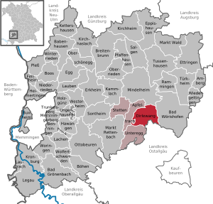
| Location of the Dirlewang market in the Unterallgäu district | ||
  |
||

Dirlewang is a market in the Swabian district of Unterallgäu . The place is the seat of the administrative community Dirlewang .


geography
Dirlewang is located in the Donau-Iller region about 30 km east of Memmingen in Central Swabia .
Expansion of the municipal area
There are districts Dirlewang, Altensteig and Helchenried.
There are eight officially named municipal parts (the type of settlement is given in brackets ):
|
|
The places Beiburg , Holzhauserin , Luwang , Tannburg and Wichstein have gone.
history
Until the church is planted
The area we see today was probably already settled in Roman times, as evidenced by excavations and grave finds. Several Roman brickworks were excavated in the municipality.
"Durniwanc" was first mentioned in a document in 919. At that time the place was in the Duchy of Swabia . Dirlewang, which was raised to the market before 1400, belonged to the rule of Mindelheim of the Electorate of Bavaria from 1617 , and Dirlewang has been a political municipality since the municipal edict of 1818 .
Incorporations
In the course of the regional reform , the communities of Helchenried and Altensteig joined on April 1, 1972 and July 1, 1972, respectively.
Population development
| year | 1840 | 1900 | 1939 | 1959 | 1961 | 1970 | 1987 | 1991 | 1995 | 2000 | 2005 | 2010 | 2015 |
| Residents | 1071 | 1096 | 1200 | 1835 | 1617 | 1540 | 1762 | 1892 | 2003 | 2098 | 2123 | 2106 | 2126 |
Between 1988 and 2018 the market grew from 1,790 to 2,172 by 382 inhabitants or 21.3%.
politics
City council and mayor
After the local elections on March 15, 2020 , the list “Together for Dirlewang” received 78.2% of the votes and eleven seats in the local council; the “Independent Citizens' Community Altensteig” accounted for 21.8% and three mandates. The distribution of seats is unchanged from the 2014 to 2020 term of office.
Alois Mayer has been the first mayor since May 1, 2008 (“Together for Dirlewang” list); he was elected for a further six years on March 15, 2020 with 89.6% of the vote.
Community finances
In 2012, the municipal tax revenue was € 1.269 million, of which € 294,000 was trade tax (net).
coat of arms
Blazon : "In red between two silver tin towers, the bases of which are made of silver and blue blocks, a closed golden gate with an entrance gate in a silver wall."
The place already had market rights before 1400, but it was not until 1725 that it was given its own coat of arms as a seal by Elector Max Emanuel II of Bavaria . The content of the historical coat of arms of the market is difficult to interpret. The red field color is identical to the main color of the coat of arms of the former prince monastery of Kempten, which Dirlewang held as a fief for several centuries until it was sold to Hans Fugger in 1587. The gate with small entrance doors between two towers gave rise to a naive and certainly inaccurate interpretation of the coat of arms for the place name (Dirle = Türlewang = for open). Much more likely, however, the coat of arms should highlight the special rights of the market at the time, such as the high level of jurisdiction, freedom from compulsory service and market law, also under Bavarian law (colors white-blue).
flag
The flag was approved by the government of Swabia on August 30, 1990.
The flag is striped yellow and blue with the municipal coat of arms.
Freising's Theodor Goerge was responsible for designing the community flag.
Architectural monuments
Economy and Infrastructure
Economy including agriculture and forestry
In 1998 there were seven in the field of agriculture and forestry, 207 in the manufacturing sector and 58 in the trade and transport sector at the place of work. In other economic sectors 83 people were employed at the place of work subject to social security contributions. There were a total of 708 employees at the place of residence subject to social security contributions. There were two companies in the manufacturing sector and six in the construction sector. In addition, in 1999 there were 61 farms with an agricultural area of 1361 ha. Of this, 1070 ha were permanent green space.
Dirlewang citizen participation battery

In May 2011, Mayor Alois Mayer announced that there were plans for a pumped storage power plant near Dirlewang. The Dirlewang location was chosen for several reasons:
- regular floods, which are held back by a newly built dam
- Nearby Roßkopf, a 700 meter high mountain on which the reservoir is to be built
- Passing power line with transformer station, so no new line would be necessary
The grid is also loaded with 6.18 megawatts, which means electricity for 20,000 people that can be stored for six hours.

traffic
The place is on the B 16 , which leads from Roding via Regensburg to Füssen. The A 96 is about three kilometers away (Mindelheim exit).
The place is a hub in bus traffic and is on the lines 912 (Mindelheim – Dirlewang), 913 (Dirlewang – Baisweil), 914 (Mindelheim – Binkenhofen) and 912 (Dirlewang – Erisried). The nearest train station is Mindelheim, about five kilometers away .
education
In 2014 there were the following institutions:
- Kindergarten Sonnenwirbel - three kindergarten groups and one daycare group
- Primary school - two-tier, 177 students
Sons and daughters

- Johann Michael Franz (1715–1793), German baroque artist
- Engelbert Buxbaum (1831–1911), mechanical engineer and member of the Reichstag
- Karl von Brug (1855–1923), Bavarian infantry general and aviation pioneer
Web links
- Local government
- Dirlewang: Official statistics of the LfStat (PDF; 1 MB)
Individual evidence
- ↑ "Data 2" sheet, Statistical Report A1200C 202041 Population of the municipalities, districts and administrative districts 1st quarter 2020 (population based on the 2011 census) ( help ).
- ^ Municipal organs in the Dirlewang market. Dirlewang parish, accessed on June 7, 2020 .
- ^ Municipality of Dirlewang in the local database of the Bavarian State Library Online . Bayerische Staatsbibliothek, accessed on August 17, 2019.
- ^ Ulrich Brandl and Emmi Federhofer: Ton + Technik. Roman bricks. Theiss, Stuttgart 2010, ISBN 978-3-8062-2403-0 ( publications from the Limes Museum Aalen. No. 61)
- ^ Wilhelm Volkert (ed.): Handbook of Bavarian offices, communities and courts 1799–1980 . CH Beck, Munich 1983, ISBN 3-406-09669-7 , p. 524 .
- ↑ Second votes, according to the source www.wahlen.bayern.de, accessed on March 4, 2018
- ^ Entry on the Dirlewang coat of arms in the database of the House of Bavarian History

Amberg |
Apple trach |
Babenhausen |
Bad Grönenbach |
Bad Wörishofen |
Benningen |
Boars |
Boos |
Breitenbrunn |
Buxheim |
Dirlewang |
Egg an der Günz |
Eppishausen |
Erkheim |
Ettringen |
Fellheim |
Hawangen |
Heimertingen |
Holzgünz |
Kammlach |
Kettershausen |
Kirchhaslach |
Kirchheim in Swabia |
Kronburg |
Laughter |
Arbors |
Lautrach |
Legau |
Market Rettenbach |
Market forest |
Memmingerberg |
Mindelheim |
Niederrieden |
Oberrieden |
Oberschönegg |
Ottobeuren |
Pfaffenhausen |
Pleas |
Rammingen |
Salgae |
Sontheim |
Stetten |
Trunkelsberg |
Türkheim |
Tussenhausen |
Ungerhausen |
Unteregg |
Westerheim |
Wiedergeltingen |
Winter peace |
Wolfertschwenden |
Woringen
Municipality-free area in the district of Unterallgäu
Ungerhauser Wald