
Oberschönegg
| coat of arms | Germany map | |
|---|---|---|

|
Coordinates: 48 ° 6 ' N , 10 ° 18' E |
|
| Basic data | ||
| State : | Bavaria | |
| Administrative region : | Swabia | |
| County : | Unterallgäu | |
| Management Community : | Babenhausen | |
| Height : | 630 m above sea level NHN | |
| Area : | 18.28 km 2 | |
| Residents: | 978 (Dec. 31, 2019) | |
| Population density : | 54 inhabitants per km 2 | |
| Postal code : | 87770 | |
| Area code : | 08333 | |
| License plate : | MN | |
| Community key : | 09 7 78 184 | |
| LOCODE : | DE OGG | |
| Community structure: | 4 parts of the community | |
| Association administration address: | Marktplatz 1 87727 Babenhausen |
|
| Website : | ||
| Mayor : | Günther Fuchs ( Wgem. / Wver. / Fr. Wver. ) | |
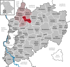
| Location of the community Oberschönegg in the Unterallgäu district | ||
  |
||


Oberschönegg is a municipality in the Swabian district of Unterallgäu and a member of the Babenhausen administrative community .
geography
Oberschönegg is located around 20 kilometers northeast of Memmingen in the Donau-Iller region in Upper Swabia .
Expansion of the municipal area
The municipality has 4 parts of the municipality (the type of settlement is given in brackets ):
- Dietershofen near Babenhausen ( parish village )
- Märxle ( hamlet )
- Oberschönegg ( Kirchdorf )
- Weinried (parish village)
The settlement of Langer Jürgen mentioned in 1580 in the Salbuch of the Schönegg nursing office and the Berghof wasteland that existed until 1933 have been abandoned.
The municipality consists of the districts Oberschönegg, Dietershofen bei Babenhausen and Weinried.
history
Until the church is planted
The castle Altenschönegg was the seat of an important Reichsministerialgeschlechts. From 1355 it was the nursing office of the Augsburg bishopric . With the Reichsdeputationshauptschluss of 1803, the place fell to Bavaria. Weinried belonged to the Fugger-Babenhausen princes from 1538/39 to 1803 . In 1818 the political municipality Oberschönegg was formed.
Territorial reform of the 1970s
The place came in the course of the district reform on July 1, 1972 from the district of Illertissen to the newly formed district of Unterallgäu. On May 1, 1978, the previously independent communities Dietershofen and Weinried were incorporated.
Population development
- 1961: 952 inhabitants
- 1970: 941 inhabitants
- 1987: 865 inhabitants
- 1991: 897 inhabitants
- 1995: 911 inhabitants
- 2000: 950 inhabitants
- 2005: 967 inhabitants
- 2010: 947 inhabitants
- 2015: 962 inhabitants
Between 1988 and 2018, the community grew from 862 to 987 by 125 inhabitants or 14.5%.
politics
mayor
Mayor is Günther Fuchs. He was succeeded Thomas Schiochet in 2008 and was confirmed in office on March 15, 2020 with 78.0% of the votes.
Municipal council
The election on March 15, 2020 had the following result:
- Weinried community of voters: 3 seats (36.3%)
- Oberschönegg voters' association: 3 seats (34.9%)
- Free voter association Dietershofen: 2 seats (28.8%)
Compared to the term of office from 2014 to 2020, the distribution of seats between the three groups of voters has not changed.
coat of arms
The coat of arms was approved by the government of Swabia on July 20, 1984.
Blazon : “Split by red and silver; in front above a silver Ulrich's cross a silver monogram of Mary, behind three (2: 1) set black mallets. "
The basis of the new municipal coat of arms is the coat of arms of the old bishopric of Augsburg, the shield split by red and silver. As a nursing office, Oberschönegg was an important administrative center within the Hochstift. The three mallets from the coat of arms of the Lords of Schönegg, whose ancestral castle was in today's municipal area, refer to medieval history. The Marian monogram is taken from the coat of arms of the Redemptorist Order and is intended to mark the stay of St. Remember Clemens Maria Hofbauer 1805/06 in Weinried. The Ulrichskreuz stands for the parish church of St. Ulrich von Dietershofen.
The coat of arms was designed by the Freising heraldist Theodor Goerge.
flag
The flag is striped white and red with the municipal coat of arms.
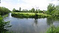
Günzmäander near Weinried
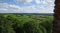
View from the Roman tower

Günztal near Oberschönegg

Günztal near Oberschönegg
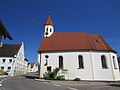
Church in Oberschönegg

Oberschönegg from the south

Weinried from the northwest


Attractions


- Remains of Altenschönegg Castle (observation tower, the so-called Römerturm)
- Filial church St. Leonhard
- Parish church St. Ulrich in Dietershofen
- Parish church of St. Laurentius in Weinried
Economy and Infrastructure
Economy including agriculture and forestry
In 1998 there were 334 in the manufacturing industry and in the trade and transport sector no employees subject to social security contributions at the place of work. In other sectors of the economy this figure was 53 people. There were 319 employees at the place of residence subject to social security contributions. There were no companies in the manufacturing or construction industry. In 1999 there were 55 farms with an agriculturally used area of 1240 ha, of which 301 ha were arable land and 939 ha were permanent green space. The Ehrmann dairy has its headquarters here.
education
In 2005 the following institution existed:
- Kindergarten: One with 50 kindergarten places and 49 children
Web links
- Entry on the coat of arms of Oberschönegg in the database of the House of Bavarian History
- Oberschönegg: Official statistics of the LfStat (PDF file; 1 MB)
Individual evidence
- ↑ "Data 2" sheet, Statistical Report A1200C 202041 Population of the municipalities, districts and administrative districts 1st quarter 2020 (population based on the 2011 census) ( help ).
- ^ Oberschönegg community in the local database of the Bavarian State Library Online . Bavarian State Library, accessed on August 15, 2019.
- ↑ a b c Federal Statistical Office (ed.): Historical municipality directory for the Federal Republic of Germany. Name, border and key number changes in municipalities, counties and administrative districts from May 27, 1970 to December 31, 1982 . W. Kohlhammer, Stuttgart / Mainz 1983, ISBN 3-17-003263-1 , p. 782 .
- ↑ Second votes, according to the source www.wahlen.bayern.de, accessed on March 4, 2018

Amberg |
Apple trach |
Babenhausen |
Bad Grönenbach |
Bad Wörishofen |
Benningen |
Boars |
Boos |
Breitenbrunn |
Buxheim |
Dirlewang |
Egg an der Günz |
Eppishausen |
Erkheim |
Ettringen |
Fellheim |
Hawangen |
Heimertingen |
Holzgünz |
Kammlach |
Kettershausen |
Kirchhaslach |
Kirchheim in Swabia |
Kronburg |
Laughter |
Arbors |
Lautrach |
Legau |
Market Rettenbach |
Market forest |
Memmingerberg |
Mindelheim |
Niederrieden |
Oberrieden |
Oberschönegg |
Ottobeuren |
Pfaffenhausen |
Pleas |
Rammingen |
Salgae |
Sontheim |
Stetten |
Trunkelsberg |
Türkheim |
Tussenhausen |
Ungerhausen |
Unteregg |
Westerheim |
Wiedergeltingen |
Winter peace |
Wolfertschwenden |
Woringen
Municipality-free area in the district of Unterallgäu
Ungerhauser Wald