
Buxheim (Swabia)
| coat of arms | Germany map | |
|---|---|---|
.svg)
|
Coordinates: 48 ° 0 ' N , 10 ° 8' E |
|
| Basic data | ||
| State : | Bavaria | |
| Administrative region : | Swabia | |
| County : | Unterallgäu | |
| Height : | 580 m above sea level NHN | |
| Area : | 10.24 km 2 | |
| Residents: | 3245 (Dec. 31, 2019) | |
| Population density : | 317 inhabitants per km 2 | |
| Postal code : | 87740 | |
| Area code : | 08331 | |
| License plate : | MN | |
| Community key : | 09 7 78 123 | |
| Community structure: | 5 parts of the community | |
| Address of the municipal administration: |
Kirchplatz 2 87740 Buxheim |
|
| Website : | ||
| First Mayor : | Wolfgang Schmidt ( CSU ) | |
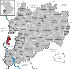
| Location of the municipality of Buxheim in the Unterallgäu district | ||
  |
||

Buxheim is a municipality in Swabia and an exclave of the Unterallgäu district .
The central Swabian community is not far from Memmingen an der Iller and is also known as the Carthusian village . Buxheim is best known for its former Imperial Charterhouse , in which the German Carthusian Museum is located.
geography
Geographical location
Buxheim is located on the Bavarian western border with Baden-Württemberg on the Iller , about four kilometers west of Memmingen in the Memminger dry valley, a part of the Danube-Iller-Lech plate that served the Iller glacier as the main drainage channel during the last Ice Age. Of course, the municipality is bounded in the west by the Iller, in the south by the Buxheimer Wald , in the east by the A 7 motorway . In the north, the Egelsee district of the city of Memmingen delimits the municipality. Buxheim is located in the Danube-Iller region in Upper Swabia . Surrounded by the independent city of Memmingen and the Württemberg district of Biberach , Buxheim forms an exclave of the Unterallgäu district.
Expansion of the municipal area
The municipality consists of part of the Buxheim district (the other part of the district belongs to Memmingen ).
There are five officially named parts of the municipality (the type of settlement is given in brackets ):
- Aumühle ( wasteland )
- Buxheim ( parish village )
- Weiherhaus ( hamlet )
- Westerhart (hamlet)
- Brick barn (wasteland)
climate
The municipality is at the average annual temperature and rainfall average of the temperate zone . The precipitation is usually somewhat higher, the minimum temperatures are somewhat lower. In spring and autumn, thick fog is quite frequent due to the nearby Iller , the Buxach flowing through the village , the Reutenbach , the Buxheimer Weiher and several ponds in the Buxheimer Wald . Since Buxheim itself does not have a weather station, the measured values from the nearby town of Memmingen serve as data. The coldest month is January with an average daily low temperature of -5 ° C and an average daily high temperature of +2 ° C. The warmest months are July and August with an average minimum temperature of 12 ° C and an average maximum temperature of 24 ° C.


|
Average temperature and precipitation values
Source: Max. And Min. Temperature: Foreca data on MSN Weather. Accessed April 2009 . ; Temperature and precipitation: German Weather Service
|
|||||||||||||||||||||||||||||||||||||||||||||||||||||||||||||||||||||||||||||||||||||||||||||||||||||||||||||||||||||||||||||||||||||||||||||||||||||||||||||||||||||
history
.jpg)
The oldest documented settlement of Buxheim is located southeast of the town on the Schloßberg , formerly called Althayn . Burial mounds and high fields indicate earlier Celtic settlement. Later there was probably a Roman watchtower on the Schlossberg. In 1228 a canon monastery of St. Augustine was mentioned in Buxheim, which was incorporated into the Augsburg monastery. It is possible that Augsburg canons lived in Buxheim as early as the 8th century, but certainly after the Hungarian invasions in the 10th century, and provided the local parish and the surrounding parish districts. The peasants placed themselves under the protection of the monastery in order to be relieved of their war obligation. The Canon Monastery again under the protection of the Guelphs of Memmingen. In the 14th century the Knights of Eisenburg were Lords of Buxheim. In 1399 they sold the property to the Augsburg canon provost Heinrich von Ellerbach . He called the Carthusians of Christgarten Monastery , who built a Carthusian monastery in Buxheim in 1402 and received all of the Buxheim property as a gift. Heinrich von Ellerbach became a Carthusian monk himself and died as the prior of the monastery. As a result, Buxheim was under the protection of the Free Imperial City of Memmingen. The property of the monastery increased through foundations and new cells were created. During the Reformation, Memmingen, already reformed at the time, wanted the Carthusians to move out of the monastery and, when they refused, massively increased taxes. The Carthusians then sought help from the Emperor, who converted the Carthusian monastery into an Imperial Charterhouse. In the Thirty Years' War Buxheim was severely afflicted. The Swedes plundered it in 1632 . In the same year Buxheim became the headquarters of the Swedish general Horn . There was then a great famine. In 1635 the plague raged in the village. In 1647 Maximilian I of Buxheim conquered Memmingen, which was occupied by the Swedes. The area of the Reich Charterhouse was secularized in 1803 and divided between the Counts of Ostein and von Wartenberg . After the von Ostein family died out, the property went to Count Waldbott von Bassenheim . You were in Buxheim for over 100 years until after the First World War . In recent years they have squandered all of their possessions. Valuable art treasures, including the choir stalls of the Charterhouse and a large part of the library, were lost. With the Rheinbund act 1806 the place came to Bavaria . In the course of the administrative reforms in Bavaria, today's municipality was created with the municipal edict of 1818 . In 1926 a monastery of the Salesians of Don Bosco was established in the buildings of the Charterhouse . Together with the diocese of Augsburg, they maintain the high school Marianum Buxheim with an attached day care center and boarding school in the former monastery complex .
On December 1, 1942, the buildings were rented to the task force of the Reichsleiter and chief ideologist of the NSDAP , Alfred Rosenberg . The Einsatzstab Reichsleiter Rosenberg (ERR) was an art theft organization during the Second World War , which was headed by Alfred Rosenberg and the Foreign Policy Office of the NSDAP (APA) led by him . From this point on there were no direct air raids on Buxheim. Stolen art objects from occupied France came into the premises of the area. 1945 Buxheim belonged to the American zone of occupation. The Americans returned 28 railway wagons with stolen items to their previous owners in France.
Population development
Between 1988 and 2018 the community grew from 2,719 to 3,202 by 483 inhabitants or 17.8%.
politics
Municipal council
The local elections on March 15, 2020 had the following result:
| CSU | SPD | FW | Colorful list | total | |
| Seats | 6th | 3 | 4th | 3 | 16 |
| percent | 38.8% | 16.7% | 23.0% | 21.6% | 100% |
The previous local election on March 16, 2014 resulted in the following official final result:
| CSU | SPD | FW | Colorful list | total | |
| Seats | 6th | 4th | 4th | 2 | 16 |
| percent | 38.6% | 21.5% | 25.9% | 14.0% | 100% |
mayor
Wolfgang Schmidt (CSU) has been mayor since July 2017. Werner Birkle (CSU) was the predecessor since 1981.
coat of arms
The coat of arms was approved on May 10, 1968 by decision of the Bavarian State Ministry of the Interior.
Blazon : “Split over a shield base quartered by gold and green; in front a golden crown of Mary in blue, at the back split by silver and red. "
Buxheim, whose history was shaped by the Imperial Charterhouse there, received its own coat of arms seal in 1548 for use by Ammann and the court. The essential components of this coat of arms are references to the Marian patronage of the Carthusian monastery, to its sponsors from the Swabian noble family of the Lords of Ellerbach and to the responsible bishopric of Augsburg. In order to eliminate various formal deficiencies in the content and relational old symbol and to justify its suitability for a modern communal emblem, the present selection was made from the given motifs, which the Carthusian monastery Buxheim (Marienkrone with reference to the old monastery name “Maria Saal “= Aula Mariae) as well as the close relationships of the place to the Lords of Ellerbach (gold - green - crossing) and ultimately connects the Augsburg symbol (silver - red - split).
The design of the coat of arms comes from the monastery archivist and district home administrator Aegidius Kolb and the design was done by Rudolf Mussgnug from Nördlingen.
flag
The flag is yellow and blue striped with the municipal coat of arms.
Community partnerships
Since July 22, 1989, Buxheim has had an official partnership with the commune of Saint-Denis-d'Anjou in the Mayenne department in France . Friendships have been cultivated for many decades through the same name as the municipality of Buxheim in the Eichstätt district in Upper Bavaria and, since 1990, with the Schönfeld district of the Wiesenbad thermal bath municipality in the Erzgebirgskreis in Saxony .
Place names
Buxheim was also spelled Bohsheim and Buchsheim earlier . It can therefore be assumed that the place name developed from the name Buchos and became Buchos home .
Culture and sights
Attractions
The biggest attraction of the place is the former Reichskartause Buxheim with the monastery church St. Maria and the Buxheimer choir stalls carved by Ignaz Waibl . Due to their work on the monastery church, the construction of the parish church of St. Peter and Paul and the Anna chapel, one of the main focuses of the activities of the brothers Johann Baptist and Dominikus Zimmermann is in Buxheim .
See also: List of architectural monuments in Buxheim (Swabia) and List of ground monuments in Buxheim (Swabia)
Museums
There are three museums in Buxheim, all on the area of the Charterhouse. The best known is the German Kartausenmuseum, founded in 1975 . In the sacral museum in the former sacristy of the monastery church, sacred objects from the Carthusian monks are exhibited and their purpose is explained using display boards. In 2006, the local history service in Buxheim set up the village museum in the old monastery parlor, with the presentation of the history of the village under the Counts of Bassenheim using exhibits .

Buxheim Forest


An extensive forest area begins on the southern edge of the village, most of which lies within the municipality of Buxheim and is roughly bounded by the Buxheimer Weiher, the Buxach Valley , the Westerhart estate and the course of the Iller . It is also an important local recreation area for Memmingen with some tourist infrastructure such as restaurants and a mini golf course in the area of the Buxheimer Weiher. On the other side of the forest area there is a golf course at Hofgut Westerhart. The interior of the area has been cut through by the Federal Motorway 96 since 1978 . However, it is otherwise closed to motorized traffic and is accessible via many cycling and hiking trails. Three small forest ponds, one of which can be bathed, are in continuation of the Buxheimer Weiher, the two even smaller Westerhart ponds are at the other end of the forest area. In addition to a medieval castle stable, remnants of alluvial forests , especially in the area of the former river meander of the Iller and forest meadows, there are several streams. The southwestern part, around half of the area, has been under landscape protection since 1973 under the title Protection of landscape parts south and east of the Iller .
Economy and Infrastructure


A medium-sized economic structure prevails in Buxheim. Hans Kolb Wellpappe operates a plant in the village and is also the largest employer in the village. The Hofgut Westerhart is now used as a restaurant and the Golf Club Memmingen as a golf course .
Due to its position as an exclave in the district, only district roads lead into the village. A bridge over the Iller to neighboring Baden-Württemberg only exists as a pedestrian walkway and railway bridge. The Memmingen motorway junction is completely on the Buxheimer Flur.
The Leutkirch – Memmingen railway runs through the town. However, there is only one alternative connection point for the operation of freight traffic . A stop is planned to be built here as part of the Donau-Iller regional S-Bahn .
Personalities
- Gregor Reisch (1470–1525), from 1501 to 1502 Carthusian prior of Buxheim Monastery
- Dietrich Loher (1495–1554), from 1543 to 1554 Carthusian Prior of the Buxheim Monastery and Provincial of the Lower Swabian Order
- Caspar Schliederer von Lachen († 1585), aristocratic canon in the prince-bishops of Speyer and Augsburg , from 1575 Carthusian prior of the Buxheim monastery, as well as a provincial order
- Joseph Lipburger (1754–1831), Carthusian prior of the Buxheim Monastery from 1806 to 1811
- Charlotte Böhler-Mueller (born April 5, 1924 in Buxheim), author, artist and journalist
- Egon Coordes (born July 13, 1944), former soccer player and soccer coach, has lived in Buxheim for a long time
- Sarah Romert (born December 13, 1994 in Memmingen), soccer player (U17 national team), started playing soccer in Buxheim
Honorary citizen
- Paul Knoblauch († August 31, 1968), Mayor, awarded January 6, 1966
- Michael Müller († August 19, 1992), Father, local history researcher, awarded July 11, 1978
- Sladys Cathleen Bush († January 6, 1983), Reverend Mother St. Savior's Hospital, merits for the repatriation of the Buxheim choir stalls from England, awarded May 5, 1981
- Friedrich Stöhlker († November 30, 2007), local history researcher, awarded January 29, 2001
No documents are available for the period up to 1945.
Web links
- Buxheim community
- Virtual Carthusian monastery of Buxheim
- Buxheim (Swabia): Official statistics of the LfStat (PDF; 1 MB)
Individual evidence
- ↑ "Data 2" sheet, Statistical Report A1200C 202041 Population of the municipalities, districts and administrative districts 1st quarter 2020 (population based on the 2011 census) ( help ).
- ↑ Municipal administration. Buxheim municipality, accessed on June 5, 2020 .
- ^ Buxheim community in the local database of the Bavarian State Library Online . Bayerische Staatsbibliothek, accessed on August 17, 2019.
- ↑ Second votes, according to the source www.wahlen.bayern.de, accessed on March 4, 2018
- ↑ Election of the municipal councils in the municipalities in Bavaria in 2014 according to municipalities. Retrieved May 17, 2017 .
- ^ Entry on the coat of arms of Buxheim (Swabia) in the database of the House of Bavarian History
- ↑ Upper Swabian place and field names , Julius Miedel , Verlag Th. Otto, Memmingen, 1906, page 32
- ↑ http://www.protectedplanet.net/395737 , accessed on May 16, 2016
- ↑ SMA / Intraplan: Regio-S-Bahn Donau-Iller results of the main study (PDF; 2.4 MB), November 27, 2012, accessed on November 19, 2013

Amberg |
Apple trach |
Babenhausen |
Bad Grönenbach |
Bad Wörishofen |
Benningen |
Boars |
Boos |
Breitenbrunn |
Buxheim |
Dirlewang |
Egg an der Günz |
Eppishausen |
Erkheim |
Ettringen |
Fellheim |
Hawangen |
Heimertingen |
Holzgünz |
Kammlach |
Kettershausen |
Kirchhaslach |
Kirchheim in Swabia |
Kronburg |
Laughter |
Arbors |
Lautrach |
Legau |
Market Rettenbach |
Market forest |
Memmingerberg |
Mindelheim |
Niederrieden |
Oberrieden |
Oberschönegg |
Ottobeuren |
Pfaffenhausen |
Pleas |
Rammingen |
Salgae |
Sontheim |
Stetten |
Trunkelsberg |
Türkheim |
Tussenhausen |
Ungerhausen |
Unteregg |
Westerheim |
Wiedergeltingen |
Winter peace |
Wolfertschwenden |
Woringen
Municipality-free area in the district of Unterallgäu
Ungerhauser Wald