
Kirchhaslach
| coat of arms | Germany map | |
|---|---|---|

|
Coordinates: 48 ° 9 ' N , 10 ° 18' E |
|
| Basic data | ||
| State : | Bavaria | |
| Administrative region : | Swabia | |
| County : | Unterallgäu | |
| Management Community : | Babenhausen | |
| Height : | 550 m above sea level NHN | |
| Area : | 32.04 km 2 | |
| Residents: | 1298 (Dec. 31, 2019) | |
| Population density : | 41 inhabitants per km 2 | |
| Postcodes : | 87755, 87770 (Beblinstetten) |
|
| Area code : | 08333 | |
| License plate : | MN | |
| Community key : | 09 7 78 157 | |
| Community structure: | 9 parts of the community | |
| Association administration address: | Marktplatz 1 87727 Babenhausen |
|
| Website : | ||
| Mayor : | Franz Grauer ( Free electorate / CSU ) | |
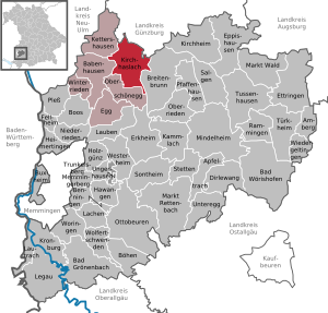
| Location of the municipality of Kirchhaslach in the Unterallgäu district | ||
  |
||

Kirchhaslach is a municipality in the Swabian district of Unterallgäu and a member of the Babenhausen administrative community .
geography

Kirchhaslach is located about 25 kilometers north of Memmingen in the Donau-Iller region in Central Swabia .
Expansion of the municipal area
The municipality consists of the districts of Kirchhaslach, Greimeltshofen, Herretshofen and Olgishofen.
The municipality has 9 officially named municipality parts :
|
|
|
history
Until the church is planted
Kirchhaslach belonged to Prince Fugger -Babenhausen. With the Rhine Confederation Act 1806 , the place came to the Kingdom of Bavaria . He was part of the rule (since 1803 imperial principality ) Babenhausen. In the course of the administrative reforms in Bavaria, the municipality was created with the municipal edict of 1818 .
Incorporations
On July 1, 1972, the previously independent municipality of Herretshofen was incorporated. On May 1, 1978 Greimeltshofen and Olgishofen were added.
Population development
- 1961: 1240 inhabitants
- 1970: 1207 inhabitants
- 1987: 1157 inhabitants
- 1991: 1202 inhabitants
- 1995: 1238 inhabitants
- 2000: 1270 inhabitants
- 2005: 1287 inhabitants
- 2010: 1302 inhabitants
- 2015: 1282 inhabitants
Between 1988 and 2018, the municipality grew from 1,166 to 1,247 by 81 inhabitants or 7%.
politics
mayor
Franz Grauer (* 1965; Free electorate / CSU ) has been mayor since 2008 ; he was confirmed in office on March 15, 2020 for a further six years.
Municipal council
In the local election on March 15, 2020 , only the joint election proposal from the free electorate and the CSU was presented, which thus received all twelve mandates in the local council. In the previous six-year term in office, the free electorate / CSU held.
coat of arms
The coat of arms was approved by the government of Swabia on October 25, 1983.
Blazon : “Split by silver and green; Above from black and silver split and lowered wave bar in front a red mill wheel, which is topped with a red pitchfork, behind a silver heraldic lily, which is set with a silver hazelnut. "
The municipality of Kirchhaslach is located in the Hasel valley (wave bar). The agricultural structure of the municipality is emphasized in the coat of arms by the green tinging and the pitchfork. The mill wheel is said to refer to a mill built by Count Fugger in 1712. The lily in the back of the coat of arms stands as a symbol of Mary for the famous pilgrimage church of the Assumption, which is the structural and spiritual center of the community. At the same time, the lily, as a symbol of the Fugger's coat of arms, indicates the historical significance of this family for the municipality. The hazelnut in the top of the lily is a very original talking symbol for the community name.
The design and design of the coat of arms go back to the Tutzinger Peter Ziller; the final artwork was done by Ludwig Zedelmaier from Babenhausen.
flag
The flag is striped red, white and green with the municipal coat of arms.
Architectural monuments


- Parish and pilgrimage church of the Assumption of Mary with rich baroque furnishings
Soil monuments
See: List of ground monuments in Kirchhaslach
Economy and Infrastructure
Economy including agriculture and forestry
In 1998 there were 68 in manufacturing and in trade and transport no employees subject to social insurance contributions at the place of work. In other economic areas, 25 people were employed at the place of work subject to social security contributions. There were 412 employees at the place of residence subject to social security contributions. There was one company in the manufacturing sector and three companies in the construction sector. In addition, in 1999 there were 83 farms with an agricultural area of 1392 hectares, of which 1084 were permanent green areas.
education
In 1999 the following institution existed:
- Kindergarten: 50 kindergarten places with 42 children
Web links
- Entry on the coat of arms of Kirchhaslach in the database of the House of Bavarian History
- Kirchhaslach: Official statistics of the LfStat (PDF; 1 MB)
- Peter Stoll: Johann Friedrich Sichelbein and the frescoes of the pilgrimage churches Kirchhaslach and Lehenbühl , Augsburg, University, 2011 (PDF; 1.9 MB)
Individual evidence
- ↑ "Data 2" sheet, Statistical Report A1200C 202041 Population of the municipalities, districts and administrative districts 1st quarter 2020 (population based on the 2011 census) ( help ).
- ↑ Kirchhaslach community in the local database of the Bayerische Landesbibliothek Online . Bavarian State Library, accessed on August 16, 2019.
- ^ Wilhelm Volkert (ed.): Handbook of Bavarian offices, communities and courts 1799–1980 . CH Beck, Munich 1983, ISBN 3-406-09669-7 , p. 488 .
- ↑ a b c Federal Statistical Office (ed.): Historical municipality directory for the Federal Republic of Germany. Name, border and key number changes in municipalities, counties and administrative districts from May 27, 1970 to December 31, 1982 . W. Kohlhammer, Stuttgart / Mainz 1983, ISBN 3-17-003263-1 , p. 782 .
- ↑ Second votes, according to the source www.wahlen.bayern.de, accessed on March 4, 2018
Kirchhaslach | Beblinstetten | Greimeltshofen | Heaps | Härtlehof | Herretshofen | Hörlis | Olgishofen | Stolzenhofen

Amberg |
Apple trach |
Babenhausen |
Bad Grönenbach |
Bad Wörishofen |
Benningen |
Boars |
Boos |
Breitenbrunn |
Buxheim |
Dirlewang |
Egg an der Günz |
Eppishausen |
Erkheim |
Ettringen |
Fellheim |
Hawangen |
Heimertingen |
Holzgünz |
Kammlach |
Kettershausen |
Kirchhaslach |
Kirchheim in Swabia |
Kronburg |
Laughter |
Arbors |
Lautrach |
Legau |
Market Rettenbach |
Market forest |
Memmingerberg |
Mindelheim |
Niederrieden |
Oberrieden |
Oberschönegg |
Ottobeuren |
Pfaffenhausen |
Pleas |
Rammingen |
Salgae |
Sontheim |
Stetten |
Trunkelsberg |
Türkheim |
Tussenhausen |
Ungerhausen |
Unteregg |
Westerheim |
Wiedergeltingen |
Winter peace |
Wolfertschwenden |
Woringen
Municipality-free area in the district of Unterallgäu
Ungerhauser Wald