Memmingerberg
| coat of arms | Germany map | |
|---|---|---|

|
Coordinates: 47 ° 59 ' N , 10 ° 12' E |
|
| Basic data | ||
| State : | Bavaria | |
| Administrative region : | Swabia | |
| County : | Unterallgäu | |
| Management Community : | Memmingerberg | |
| Height : | 600 m above sea level NHN | |
| Area : | 6.09 km 2 | |
| Residents: | 3164 (Dec. 31, 2019) | |
| Population density : | 520 inhabitants per km 2 | |
| Postal code : | 87766 | |
| Area code : | 08331 | |
| License plate : | MN | |
| Community key : | 09 7 78 171 | |
| LOCODE : | DE MQB | |
| Community structure: | 2 parts of the community | |
| Address of the municipal administration: |
Benninger Str. 3 87766 Memmingerberg |
|
| Website : | ||
| Mayor : | Alwin Lichtensteiger ( CSU / Citizens' Block) | |
| Location of the municipality of Memmingerberg in the Unterallgäu district | ||
Memmingerberg is a municipality in the Swabian district of Unterallgäu and the seat of the Memmingerberg administrative community .
geography
Memmingerberg is located directly on the city limits of Memmingen in the Donau-Iller region in Central Swabia . The altitude of the community is 595 to 633 m above sea level. NHN .
The municipality consists only of the district Memmingerberg. The municipality has 2 officially named municipal parts (the type of settlement is indicated in brackets ):
- Künersberg ( village )
- Memmingerberg ( parish village )
history
Until the church is planted
Berg is first mentioned in 1121 when the Ottobeuren monastery received three courtyards from Kirchberger Ministeriale. The name Memmingerberg appeared as early as 1628, but was not officially introduced until 1838. The red paw cross comes from the coat of arms of Memmingen and shows the close connection to the imperial city. The patronage of the parish church St. Gordian and Epimachus in Memmingerberg suggests that the place was founded in the 9th to 10th centuries. The two saints have only been venerated in the Illergau since the 9th century and are based on an activity of the Kempten Monastery around this time in today's municipal area. The Heilig-Geist-Spital of Memmingen has been wealthy in the municipality since 1320. Around 1500 the lower hospital of Memmingen was the largest landlord. The imperial city of Memmingen exercised the highest jurisdiction in the place since 1548, which was confirmed in 1749. The angel neck jug stands for the place Künersberg, which is located in the municipality. The banker Jakob Küner (1697 to 1764), who was born in Volkratshofen near Memmingen and lives in Vienna , acquired the place from which he gave his name in 1741. While building his mansion, he discovered soil there that was suitable for the manufacture of porcelain. In 1745 he founded a faience factory that existed until 1768. Künersberg faiences were among the best German ceramics of the 18th century. In 1746, Küner received an imperial privilege for the entire Swabian district, and associated with it duty-free for his ceramics. After his death and the bankruptcy of the family, the production of faience in Künersberg was stopped. The lower hospital acquired the place in 1799, which remained in its possession until the secularization in 1803.
The town has belonged to Bavaria since the Reichsdeputationshauptschluss in 1803. In 1818 the political municipality was established.
20th and 21st centuries
The airfield in Memmingerberg was built in 1935 and 1936 . After the Second World War, the barracks area belonging to the airfield was used as a camp for refugees and displaced persons from the German eastern regions and the Soviet Zone. The Bundeswehr operational from 1956 until its dissolution in 2003, the square with the Fighter Bomber Wing 34 Allgäu . Most recently, Luftwaffe tornadoes were stationed in the community. The airport now operates under the name Memmingen Airport . Since August 5, 2004 this has been open for civil flight operations in general aviation.
Administrative community
Since the municipal reform in 1978, the municipality has been the seat of the Memmingerberg administrative association.
Population development
- 1961: 2740 inhabitants
- 1970: 2535 inhabitants
- 1987: 2023 inhabitants
- 1991: 2108 inhabitants
- 1995: 2551 inhabitants
- 2000: 2545 inhabitants
- 2005: 2582 inhabitants
- 2010: 2603 inhabitants
- 2015: 2825 inhabitants
Between 1988 and 2018 the community grew from 2,041 to 3,139 by 1,098 inhabitants or 53.8% - the highest percentage increase in the district in the period mentioned.
population
At 95.15%, German citizens make up the majority of the population in Memmingerberg. 4.85% of the residents are foreign nationals.
religion
According to the 2011 census, 40.43% Protestant Christians and 37.74% Roman Catholic Christians live in Memmingerberg. The Assumption of Mary was a public holiday until 2013. From 2014 this is no longer a public holiday in Memmingerberg.
politics
mayor
Alwin Lichtensteiger (* 1971) (CSU / Bürgerblock) has been mayor since 2008.
Municipal council
The distribution of seats in the 2014 municipal council elections was as follows:
- CSU 7 seats
- Citizens' block: 7 seats
coat of arms
The coat of arms was approved by the government of Swabia on July 1, 1982.
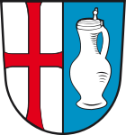
Blazon : “Split by silver and blue; in front a continuous red paw cross, behind a silver narrow-necked jug with lid. "
The Memmingen hospital has been wealthy in Memmingerberg since 1320; since 1548 (confirmed in 1749) the imperial city of Memmingen exercised the highest jurisdiction in the place. This affiliation to the territory of the imperial city of Memmingen was expressed in the municipal coat of arms through the adoption of the red paw cross from the Memmingen city coat of arms. Within the parish corridor is the place Künersberg, whose name goes back to Jakob von Küner (1697–1764), a pastor's son from Volkratshofen who rose to become an important banker in Vienna and founded a faience factory in Künersberg that existed from 1745 to 1768 and whose products are very much appreciated today. The memory of this faience factory should be kept alive by the narrow neck jug. The silver - blue coloring of the rear field also indicates that it has belonged to Bavaria since the imperial city of Memmingen was mediatized in 1803.
The coat of arms was designed by the Memmingen heraldist Uli Braun.
flag
The flag is red and white striped with the municipal coat of arms.
Architectural monuments
Soil monuments
Economy and Infrastructure
Economy including agriculture and forestry
In 1998 there were no employees subject to social insurance contributions in the manufacturing sector 205 and in the trade and transport sector. In other economic areas, 674 people were employed at the place of work subject to social security contributions. There were a total of 897 employees at the place of residence subject to social insurance contributions. There were two companies in the manufacturing sector and four in the construction sector. In addition, in 1999 there were 16 farms with an agricultural area of 346 ha, of which 128 ha were arable land and 218 ha were permanent green space.
traffic
Memmingen Airport is located in the district of Memmingerberg .
education
In 1999 the following institutions existed:
- Kindergartens: 100 kindergarten places with 83 children
- Elementary school: one with 34 teachers and 612 students
literature
- Hermann Haisch (Ed.): Landkreis Unterallgäu . tape 2 . Memminger Zeitung Verlagsdruckerei, Memmingen 1987, ISBN 3-9800649-2-1 , p. 1138-1142 .
Web links
- Entry on the coat of arms of Memmingerberg in the database of the House of Bavarian History
- Website of the municipality of Memmingerberg
- Memmingerberg: Official statistics of the LfStat (PDF file; 1 MB)
Individual evidence
- ↑ "Data 2" sheet, Statistical Report A1200C 202041 Population of the municipalities, districts and administrative districts 1st quarter 2020 (population based on the 2011 census) ( help ).
- ^ Municipality of Memmingerberg in the local database of the Bavarian State Library Online . Bavarian State Library, accessed on August 15, 2019.
- ↑ Landkreis Unterallgäu, Volume II, page 1138 ff.
- ↑ Landkreis Unterallgäu, Volume II, page 1138
- ↑ https://results.zensus2011.de/#StaticContent:097785765171,BEV_1_3_1,m,table
- ↑ https://results.zensus2011.de/#StaticContent:097785765171,BEV_1_4_1_7,m,table
- ↑ Second votes, according to the source www.wahlen.bayern.de, accessed on March 4, 2018
- ↑ Local elections in Bavaria on March 16, 2014 - results in Swabia , accessed on November 18, 2017.


