
Administrative community Memmingerberg
| coat of arms | Germany map | |
|---|---|---|
 Help on coat of arms |
Coordinates: 47 ° 59 ' N , 10 ° 13' E |
|
| Basic data | ||
| Existing period: | 1978– | |
| State : | Bavaria | |
| Administrative region : | Swabia | |
| County : | Unterallgäu | |
| Area : | 51.64 km 2 | |
| Residents: | 11,086 (Dec. 31, 2019) | |
| Population density : | 215 inhabitants per km 2 | |
| License plate : | MN | |
| Association key : | 09 7 78 5765 | |
| Association structure: | 6 municipalities | |
| Association administration address : |
Benninger Str. 3 87766 Memmingerberg |
|
| Website : | ||
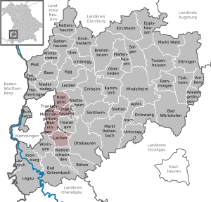
| Location of the administrative community Memmingerberg in the Unterallgäu district | ||
  |
||

The administrative community Memmingerberg in the Swabian district of Unterallgäu has existed since the municipal reform on May 1, 1978. Its member communities are:
- Benningen , 2042 inhabitants, 11.18 km²
- Holzgünz , 1364 inhabitants, 12.09 km²
- Lachen , 1688 inhabitants, 13.32 km²
- Memmingerberg , population 3164, 6.09 km²
- Trunkelsberg , 1707 inhabitants, 1.94 km²
- Ungerhausen , 1121 inhabitants, 7.02 km²
The administrative association is based in Memmingerberg.
Individual evidence
- ↑ "Data 2" sheet, Statistical Report A1200C 202041 Population of the municipalities, districts and administrative districts 1st quarter 2020 (population based on the 2011 census) ( help ).
Administrative communities in the Unterallgäu district
Babenhausen |
Bad Grönenbach |
Boos |
Dirlewang |
Erkheim |
Illerwinkel |
Kirchheim in Swabia |
Memmingerberg |
Ottobeuren |
Pfaffenhausen |
Türkheim
dissolved:
Tussenhausen