
Administrative community Illerwinkel
| coat of arms | Germany map | |
|---|---|---|

|
Coordinates: 47 ° 51 ' N , 10 ° 8' E |
|
| Basic data | ||
| Existing period: | 1978– | |
| State : | Bavaria | |
| Administrative region : | Swabia | |
| County : | Unterallgäu | |
| Area : | 64.68 km 2 | |
| Residents: | 6338 (Dec. 31, 2019) | |
| Population density : | 98 inhabitants per km 2 | |
| License plate : | MN | |
| Association key : | 09 7 78 5767 | |
| Association structure: | 3 municipalities | |
| Association administration address : |
Marktplatz 1 87764 Legau |
|
| Website : | ||
| Mayor : | Franz Abele | |
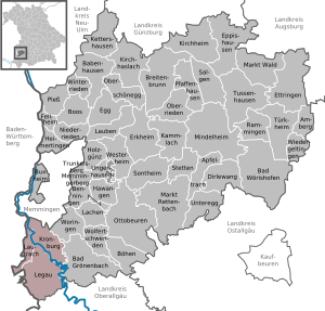
| Location of the administrative community Illerwinkel in the Unterallgäu district | ||
  |
||

The administrative community of Illerwinkel in the Swabian district of Unterallgäu has existed since the municipal reform on May 1, 1978 . You belong as member communities:
- Kronburg , 1770 inhabitants, 20.26 km²
- Lautrach , population 1278, 8.06 km²
- Legau , market , 3290 inhabitants, 36.36 km²
The administrative association is based in Legau.
history
In January 1971 the Bavarian State Parliament decided on the territorial reform for the Bavarian districts and independent cities . In the subsequent municipal reform in the Illerwinkel, the government of Swabia issued an ordinance on April 5, 1976, according to which the municipalities of Maria Steinbach were incorporated into the Legau market and Kardorf into the Kronburg municipality .
Individual evidence
- ↑ "Data 2" sheet, Statistical Report A1200C 202041 Population of the municipalities, districts and administrative districts 1st quarter 2020 (population based on the 2011 census) ( help ).
Babenhausen |
Bad Grönenbach |
Boos |
Dirlewang |
Erkheim |
Illerwinkel |
Kirchheim in Swabia |
Memmingerberg |
Ottobeuren |
Pfaffenhausen |
Türkheim
dissolved:
Tussenhausen