
Bad Grönenbach administrative community
| coat of arms | Germany map | |
|---|---|---|
 Help on coat of arms |
Coordinates: 47 ° 53 ' N , 10 ° 13' E |
|
| Basic data | ||
| Existing period: | 1978– | |
| State : | Bavaria | |
| Administrative region : | Swabia | |
| County : | Unterallgäu | |
| Area : | 74.05 km 2 | |
| Residents: | 9847 (Dec. 31, 2019) | |
| Population density : | 133 inhabitants per km 2 | |
| License plate : | MN | |
| Association key : | 09 7 78 5768 | |
| Association structure: | 3 municipalities | |
| Association administration address : |
Marktplatz 1 87730 Bad Grönenbach |
|
| Website : | ||
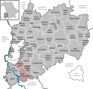
| Location of the Bad Grönenbach administrative community in the Unterallgäu district | ||
  |
||

The administrative community Gronenbach in Swabian Unterallgäu existed since the municipal reform at the 1. May 1978 . You belong as member communities:
- Bad Grönenbach , market , 5675 inhabitants, 42.02 km²
- Wolfertschwenden , 2070 inhabitants, 14.48 km²
- Woringen , population 2102, 17.55 km
The administrative association is based in Bad Grönenbach.
history
In 2007 the municipality of Wolfertschwenden wanted to leave the administrative community. This was decided negatively by the state government , so that it remained with the administrative community. The second attempt also failed due to the decision of the Bavarian State Parliament on December 4, 2012.
Population development
| district | 2012 | 2011 | 2010 | 2009 | 2008 | 2007 | 2006 | 2005 | 2004 | 2003 | 2002 | 2001 | 2000 | 1999 | 1998 | 1997 | 1996 |
| Bad Groenenbach | 5293 | 5281 | 5286 | 5285 | 5254 | 5225 | 5219 | 5204 | 5261 | 5188 | 5172 | 5151 | 5103 | 5044 | 5084 | 5091 | 5033 |
| Wolfertschwenden | 1870 | 1852 | 1835 | 1834 | 1858 | 1867 | 1871 | 1873 | 1841 | 1830 | 1823 | 1819 | 1753 | 1733 | 1707 | 1679 | 1661 |
| Woringen | 1865 | 1875 | 1868 | 1890 | 1886 | 1883 | 1865 | 1831 | 1817 | 1794 | 1771 | 1754 | 1661 | 1622 | 1616 | 1605 | 1549 |
| total | 9028 | 9008 | 8989 | 9009 | 8998 | 8975 | 8955 | 8908 | 8919 | 8812 | 8766 | 8724 | 8517 | 8399 | 8407 | 8375 | 8243 |
Individual evidence
- ↑ "Data 2" sheet, Statistical Report A1200C 202041 Population of the municipalities, districts and administrative districts 1st quarter 2020 (population based on the 2011 census) ( help ).
- ↑ Bayer's case folder. Landtag, accessed on December 7, 2012
Administrative communities in the Unterallgäu district
Babenhausen |
Bad Grönenbach |
Boos |
Dirlewang |
Erkheim |
Illerwinkel |
Kirchheim in Swabia |
Memmingerberg |
Ottobeuren |
Pfaffenhausen |
Türkheim
dissolved:
Tussenhausen