
Erkheim
| coat of arms | Germany map | |
|---|---|---|

|
Coordinates: 48 ° 2 ′ N , 10 ° 20 ′ E |
|
| Basic data | ||
| State : | Bavaria | |
| Administrative region : | Swabia | |
| County : | Unterallgäu | |
| Management Community : | Erkheim | |
| Height : | 598 m above sea level NHN | |
| Area : | 32.17 km 2 | |
| Residents: | 3148 (Dec. 31, 2019) | |
| Population density : | 98 inhabitants per km 2 | |
| Postal code : | 87746 | |
| Area code : | 08336 | |
| License plate : | MN | |
| Community key : | 09 7 78 136 | |
| Market structure: | 10 parish parts | |
Market administration address : |
Marktstrasse 1 87746 Erkheim |
|
| Website : | ||
| Mayor : | Christian Seeberger (Christian Voters' Association) | |
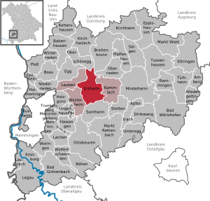
| Location of the Erkheim market in the Unterallgäu district | ||
  |
||


Erkheim is a market in the Swabian district of Unterallgäu and the seat of the Erkheim administrative community .
geography

location
Erkheim is located 15 kilometers east of Memmingen in Upper Swabia . In the south, Erkheim is bounded by the A 96 motorway . To the south there is a small industrial area that belongs to the market town. In the west, the landmarks Schindergarten and Rollenberg delimit the municipality, in the east the Outer Riedbach forms the border. The Eastern Günz flows through the middle of the village . To the east of the outer Riedbach lies the Ried , a small moor landscape in which the waterworks, which are important for the water supply of the market, are located. To the southwest, the Egelsberg rises at around 625 meters above sea level.
Community structure
There are ten officially named parts of the municipality (the type of settlement is given in brackets ):
|
|
The hamlets of Hauggenhöfe and Kreiwang are not officially named parts of the municipality.
history
Until the church is planted
Erkheim was first mentioned in a document in 764 and in 1176 in detail. Until 1803 the rule of Erkheim was split up. About three quarters of the property belonged to the Imperial Abbey of Ottobeuren , a quarter and the community part of Dankelsried to the city of Memmingen , more precisely to the Unterhospitalstiftung . Since the Reichsdeputationshauptschluss of 1803 the place belongs to Bavaria. In 1818 the political municipality was established.
District affiliation
After the Second World War , the village belonged to the district of Memmingen . During the reorganization, the place became part of the Mindelheim district on July 1, 1972, which was officially renamed the Unterallgäu district on May 1, 1973 .
Incorporations
On July 1, 1972, the previously independent communities Arlesried and Daxberg were incorporated. On May 1, 1978 Schlegelsberg was added.
Population development
| year | 1840 | 1900 | 1939 | 1959 | 1961 | 1970 | 1987 | 1991 | 1995 | 2000 | 2005 | 2010 | 2015 | 2018 |
| Residents | 1323 | 1508 | 1801 | 2634 | 2403 | 2526 | 2560 | 2726 | 2828 | 2906 | 2987 | 2908 | 2970 | 3099 |
Between 1988 and 2018 the market grew from 2,586 to 3,099 by 513 inhabitants or 19.8%.
politics
City council and mayor
Received in the local elections in Bavaria on March 15, 2020
- Christian electoral association: eight seats
- Independent list: five seats
- Citizen block: three seats
The following mayors have held office in the past decades:
- Until 1990: Karl Kusterer (Christian voter association)
- 1990–2002: Ignaz Heinle ( CSU , Christian voter association)
- 2002–2008: Konrad Engel (independent, proposed by: Independent List)
- 2008–2014: Peter Wassermann (Christian Voter Association)
- Since 2014: Christian Seeberger (CSU, Christian voter association)
Community finances
In 2012 the municipal tax revenue amounted to 2,946,000 euros, of which 1,283,000 euros were trade tax revenues (net).
coat of arms
The coat of arms was approved by the government of Swabia on September 17, 1990.
Blazon : "A high-gabled house with oriel turrets at the four corners and on the ridge."
The Erkheim market has one of the few so-called image seals. It reproduces the former castle of Ottobeuren Abbey in the center of Erkheim, as contemporary representations showed as early as 1690.
Another peculiarity is that the seal image awarded on April 27, 1875 by the Bavarian State Ministry of Foreign Affairs and the Royal House was fixed without blazon. But probably already some time after the award of the seal, the market in Erkheim introduced a colored coat of arms derived from the picture seal, which is considered a historical coat of arms.
Max Reinhart from Passau took over the artistic redesign of the coat of arms.
flag
The flag is striped white and red with the municipal coat of arms. It was approved by the government of Swabia on March 18, 1991.
Town twinning
Erkheim has had a partnership with the municipality of Saint-Hilaire-Saint-Mesmin in the Loiret department in France since 1999 . The community partnership with the community of Sins in the canton of Aargau in Switzerland has existed for a long time .
Partnerships among clubs
The Daxberg Volunteer Fire Brigade in Unterallgäu has had a partnership with the Daxberg Volunteer Fire Brigade from Lower Franconia since 1990 . The Musikkapelle Markt Erkheim maintains friendly relations with the music society Sins / Aargau in Switzerland and the Societé musicale from St. Hilaire-St. Mesmin in France.


Culture and sights
- Catholic Church of the Assumption of Mary
- Evangelical Peter and Paul Church
- In 1996, based on a design by Diether Kunerth , the Baufritz company built the largest wooden head in Germany right next to the A 96 on the occasion of its centenary.

- Allgäu-Swabian village school museum in the old schoolhouse in the Daxberg district
- Mariental: The Mariental pilgrimage site is located on the municipal boundary between the Arlesried district and Maria Baumgärtle. The hermit Heinrich Maucher lives in the middle of the forest in the middle of his pilgrimage site.
Economy and Infrastructure
economy
In 2012, there were 13 employees in agriculture and forestry, 727 in manufacturing and 171 in trade, transport and hospitality at the place of work. In other economic sectors 135 people were employed at the place of work subject to social security contributions. There were a total of 1211 employees at the place of residence subject to social security contributions. There were two companies in the manufacturing sector and eight in the construction sector. In 2010 there were 56 farms with an agricultural area totaling 1953 hectares, of which 770 were arable land and 1183 were permanent green areas.
Local companies

The economy of the market in Erkheim is medium-sized. The Baufritz company is the largest employer. At the Erkheim motorway junction in the south of the market town, an industrial area was created with the expansion of the A 96.
Transport links
Erkheim is connected to the regional road network with its own motorway access to the A 96 motorway. The A 7 can be reached via the Memmingen motorway junction about 15 kilometers to the west . The MN 13 district road runs through the town in a north-south direction , while the B 18 runs along the southern edge of the town .
At the nearest train station in Sontheim , three kilometers away, there are hourly connections on the Buchloe – Memmingen line to Memmingen and Munich . The nearest airport, Memmingen, is only 15 kilometers west of the town and can also be reached via the A 6. The Munich airport is located about 100 kilometers east, the Stuttgart airport about 100 kilometers west of Erkheim; both can be reached via the motorway.
education
In Erkheim there is a kindergarten with 125 kindergarten places and a crèche. The kindergarten and the crèche have received several awards for their sustainable educational concept, the condition of the areas and outdoor facilities and the training of the staff. In addition, there is a company day-care center run by the Baufritz company , which is also available to residents of Erkheim.
As part of the Bavarian school reform, the elementary school in Erkheim was divided into a primary school and a middle school on August 1, 2010. Secondary schools in the nearby cities of Memmingen , Ottobeuren and Mindelheim can be reached by school buses.
Healthcare
A doctor's office, an ophthalmologist, a dentist and a rehabilitation practice are housed in a medical center built in 2014. In 2014, a nursing home was set up in the former dairy.
Press
The historical affiliation to the former district of Memmingen is made clear by the circulation area of the Memminger Zeitung , which ends in Erkheim. The Mindelheimer Zeitung is distributed three kilometers further, in Kammlach, across from the Kohlberg.
Sports
In the west of Erkheim there is the sports center of TV Erkheim with tennis courts, ice rink and several soccer fields. The main football pitch has a grandstand with a capacity of 400 people. The first soccer team of TV Erkheim has been playing in the district league Schwaben Süd since the 2011/12 season .

Personalities
Richard KH Burkart , visual artist, * 1950 in Memmingen, grew up at Memminger Strasse 7 in Erkheim and lived there until he moved to Berlin. He published works in numerous libraries and museums. His studio is in Berlin-Kreuzberg.
Regular events
- Spring market: On the penultimate Sunday in March there is a grocer's market with an EVG sales exhibition.
- Every May 1st there is a big May festival with May games on the Square of Friendship.
- On the second weekend in July, the Erkheimer Volksfest takes place every year from Friday evening to Monday evening with a large beer tent and rides on the festival meadow. A large grocer's market and a flea market are held on Sundays. On Monday evening, the popular event Erkheim, as it sings and laughs, takes place in the beer tent with the Erkheim music band and local dialect artists.
- Autumn market: On the penultimate Sunday in October there is a grocer's market with an EVG sales exhibition.
- Klausenumzug: On the first Advent there is an annual large St. Nicholas parade with an average of approx. 2000 to 3000 spectators.
- Nikolauslauf: On the second Advent the TV Erkheim organizes a nationally known street run through Erkheim.
Web links
- market community
- Erkheim: Official statistics of the LfStat (PDF; 1 MB)
Individual evidence
- ↑ "Data 2" sheet, Statistical Report A1200C 202041 Population of the municipalities, districts and administrative districts 1st quarter 2020 (population based on the 2011 census) ( help ).
- ↑ Municipal Council. Erkheim community, accessed on June 26, 2020 .
- ^ Community of Erkheim in the local database of the Bavarian State Library Online . Bayerische Staatsbibliothek, accessed on August 17, 2019.
- ↑ General information on the market town of Erkheim. Erkheim community, accessed on November 6, 2017 .
- ^ Wilhelm Volkert (ed.): Handbook of Bavarian offices, communities and courts 1799–1980 . CH Beck, Munich 1983, ISBN 3-406-09669-7 , p. 521 .
- ^ Federal Statistical Office (ed.): Historical municipality directory for the Federal Republic of Germany. Name, border and key number changes in municipalities, counties and administrative districts from May 27, 1970 to December 31, 1982 . W. Kohlhammer, Stuttgart / Mainz 1983, ISBN 3-17-003263-1 , p. 782 .
- ↑ Regional results of the 2013 Bundestag election. Accessed on September 14, 2014 .
- ↑ Bavaria's municipalities. Market Erkheim - coat of arms. House of Bavarian History, accessed on July 27, 2015 .
- ↑ Johann Stoll: This man has been living as a hermit in a forest for 30 years. Augsburger Allgemeine, March 29, 2015, accessed September 30, 2015 .
- ↑ Richard Burkart's biography from the Museum Junge Kunst
- ↑ Excerpt from the artistic work of Richard Burkhart

District Arlesried : Arlesried | Drinking love
District Daxberg : Daxberg | Moss mill
District Erkheim : Brandholz | Erkheim | Dankelsried | Erlenberg | Kreiwang | Lerchenberg | Untererlenberg | Zoller
District Schlegelsberg : Hauggenhöfe | Knaus | Pulshof | Schlegelsberg

Amberg |
Apple trach |
Babenhausen |
Bad Grönenbach |
Bad Wörishofen |
Benningen |
Boars |
Boos |
Breitenbrunn |
Buxheim |
Dirlewang |
Egg an der Günz |
Eppishausen |
Erkheim |
Ettringen |
Fellheim |
Hawangen |
Heimertingen |
Holzgünz |
Kammlach |
Kettershausen |
Kirchhaslach |
Kirchheim in Swabia |
Kronburg |
Laughter |
Arbors |
Lautrach |
Legau |
Market Rettenbach |
Market forest |
Memmingerberg |
Mindelheim |
Niederrieden |
Oberrieden |
Oberschönegg |
Ottobeuren |
Pfaffenhausen |
Pleas |
Rammingen |
Salgae |
Sontheim |
Stetten |
Trunkelsberg |
Türkheim |
Tussenhausen |
Ungerhausen |
Unteregg |
Westerheim |
Wiedergeltingen |
Winter peace |
Wolfertschwenden |
Woringen
Municipality-free area in the district of Unterallgäu
Ungerhauser Wald