
Unteregg
| coat of arms | Germany map | |
|---|---|---|

|
Coordinates: 47 ° 58 ' N , 10 ° 28' E |
|
| Basic data | ||
| State : | Bavaria | |
| Administrative region : | Swabia | |
| County : | Unterallgäu | |
| Management Community : | Dirlewang | |
| Height : | 717 m above sea level NHN | |
| Area : | 23.69 km 2 | |
| Residents: | 1387 (Dec. 31, 2019) | |
| Population density : | 59 inhabitants per km 2 | |
| Postal code : | 87782 | |
| Area code : | 08269 | |
| License plate : | MN | |
| Community key : | 09 7 78 207 | |
| Community structure: | 7 parts of the community | |
| Association administration address: | Marktstrasse 19 87742 Dirlewang |
|
| Website : | ||
| Mayoress : | Marlene Preißinger ( Free Voters ) | |
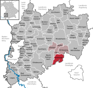
| Location of the Unteregg community in the Unterallgäu district | ||
  |
||

Unteregg is a municipality in the Swabian district of Unterallgäu and a member of the Dirlewang administrative community .
geography
Unteregg is located about 35 kilometers southeast of Memmingen in the Donau-Iller region in Central Swabia .
Expansion of the municipal area
The municipality consists of the districts Unteregg, Oberegg and Warmisried .
Unteregg has 7 officially named municipal parts :
- Bittenau ( hamlet )
- Eßmühle (hamlet)
- Oberegg ( Kirchdorf )
- Rappen ( village )
- Schlottermühle ( wasteland )
- Unteregg ( parish village )
- Warmisried (parish village)
history
Until the church is planted
Unteregg belonged to the Ottobeuren imperial abbey . Until the middle of the 18th century, large parts of today's municipal area were under the imperial knighthood of Stein. Since the Reichsdeputationshauptschluss of 1803 the place belongs to Bavaria. In the course of the administrative reforms in the Kingdom of Bavaria , today's municipality was created with the municipal edict of 1818 .
Religions
In Unteregg there are mostly Catholics .
Incorporations
On May 1, 1978, the Unteregg community was re-established through the voluntary merger of the three previously independent communities Warmisried, Oberegg and Unteregg as part of the municipal reform .
Population development
- 1961: 1229 inhabitants
- 1970: 1193 inhabitants
- 1987: 1218 inhabitants
- 1991: 1290 inhabitants
- 1995: 1335 inhabitants
- 2000: 1351 inhabitants
- 2005: 1348 inhabitants
- 2010: 1404 inhabitants
- 2011: 1368 inhabitants
- 2012: 1348 inhabitants
- 2013: 1365 inhabitants
- 2014: 1349 inhabitants
- 2015: 1361 inhabitants
Between 1988 and 2018 the community grew from 1,246 to 1,394 by 148 inhabitants or 11.9%.

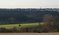
Mindeltal near Oberegg with alpine panorama

Mindeltal with Oberegg
Mindeltal with Unteregg
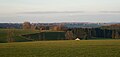
Oberegg and Unteregg from the south
Unteregg from the south

Wayside shrine in Unteregg


politics
Mayoress
Mayor has been Marlene Preißinger ( Free Voters Bavaria ) since September 20, 2007 ; she was elected for a further six years on March 15, 2020 with 90.7% of the vote.
Municipal council
The election on March 15, 2020 had the following result:
- Free voter group Warmisried: 5 seats (41.2%)
- Oberegg civic block: 4 seats (30.0%)
- Unteregg voter community: 3 seats (28.9%)
Compared to the 2014 election, the Oberegg civic block had to hand over a mandate to the Warmisried Free Voting Group.
coat of arms
The coat of arms was approved by the government of Swabia on August 28, 1985 .
Blazon : “Under a silver shield head, inside a red bar , split by a twisted silver tip, inside a blue Ulrich cross . In front a golden rosette in black, behind in blue a golden bow crown with red stones. "
Until the 18th century, the municipality was predominantly under the imperial knighthood of Stein. Parts of the rule, including Unteregg and Oberegg, were acquired by the Ottobeuren monastery in 1757, from whose coat of arms the rose window in the front part of the municipal coat of arms comes. The crown refers to the patronage “Patrona Bavariae” of the church in Oberegg, the Ulrichskreuz to the Ulrichskirche in the district of Warmisried. The red bar in the main shield is reminiscent of the old salt road with toll that led through the municipality.
The design and design of the coat of arms comes from Freising's Theodor Goerge.
flag
A flag in white - blue - white with the municipal coat of arms was approved in 1985, but is not used.
Community partnerships
The partner municipality is Emmelsbüll in North Friesland.
Culture and sights
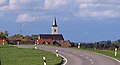
The church of St. Martin from the second half of the 15th century is located in Unteregg .
Architectural monuments
_01.JPG)
Economy and Infrastructure
Economy including agriculture and forestry
In 1998, according to official statistics, there were no employees at the place of work subject to social insurance contributions in the manufacturing industry 99 or in the trade and transport sector. In other economic sectors, eight people were employed at the place of work subject to social security contributions. There were a total of 422 employees at the place of residence subject to social security contributions. There were three companies in the manufacturing sector and five in the construction sector. In addition, in 1999 there were 84 farms with an agricultural area of 1697 ha, 1661 ha of which were permanent green space.
traffic
The so-called Mindeltalstraße, which leads across the Mindeltal, runs through Unteregg.
education
There is a kindergarten with 50 kindergarten places and 41 supervised children (as of 1999). In 2007 he took the name Sterntaler.
Personalities
- Johann Anwander (1715–1770), rococo painter and fresco artist, born in Unteregg
- Johann Nepomuk Holzhey (1741–1809), organ builder, born in Rappen
Web links
- Entry on the Unteregg coat of arms in the database of the House of Bavarian History
- Unteregg: Official statistics of the LfStat (PDF file; 1 MB)
Individual evidence
- ↑ "Data 2" sheet, Statistical Report A1200C 202041 Population of the municipalities, districts and administrative districts 1st quarter 2020 (population based on the 2011 census) ( help ).
- ^ Municipality of Unteregg in the local database of the Bavarian State Library Online . Bavarian State Library, accessed on August 15, 2019.
- ↑ a b c Federal Statistical Office (ed.): Historical municipality directory for the Federal Republic of Germany. Name, border and key number changes in municipalities, counties and administrative districts from May 27, 1970 to December 31, 1982 . W. Kohlhammer, Stuttgart / Mainz 1983, ISBN 3-17-003263-1 , p. 783 .
- ↑ Second votes, according to the source www.wahlen.bayern.de, accessed on March 4, 2018
- ↑ Entry on Unteregg on the website kommunalflaggen.eu
Unteregg | Bittenau | Dining mill | Oberegg | Rappen | Schlottermühle | Warmisried

Amberg |
Apple trach |
Babenhausen |
Bad Grönenbach |
Bad Wörishofen |
Benningen |
Boars |
Boos |
Breitenbrunn |
Buxheim |
Dirlewang |
Egg an der Günz |
Eppishausen |
Erkheim |
Ettringen |
Fellheim |
Hawangen |
Heimertingen |
Holzgünz |
Kammlach |
Kettershausen |
Kirchhaslach |
Kirchheim in Swabia |
Kronburg |
Laughter |
Arbors |
Lautrach |
Legau |
Market Rettenbach |
Market forest |
Memmingerberg |
Mindelheim |
Niederrieden |
Oberrieden |
Oberschönegg |
Ottobeuren |
Pfaffenhausen |
Pleas |
Rammingen |
Salgae |
Sontheim |
Stetten |
Trunkelsberg |
Türkheim |
Tussenhausen |
Ungerhausen |
Unteregg |
Westerheim |
Wiedergeltingen |
Winter peace |
Wolfertschwenden |
Woringen
Municipality-free area in the district of Unterallgäu
Ungerhauser Wald