
Apple strain
| coat of arms | Germany map | |
|---|---|---|

|
Coordinates: 48 ° 1 ′ N , 10 ° 30 ′ E |
|
| Basic data | ||
| State : | Bavaria | |
| Administrative region : | Swabia | |
| County : | Unterallgäu | |
| Management Community : | Dirlewang | |
| Height : | 620 m above sea level NHN | |
| Area : | 15.01 km 2 | |
| Residents: | 950 (Dec. 31, 2019) | |
| Population density : | 63 inhabitants per km 2 | |
| Postal code : | 87742 | |
| Area code : | 08261 | |
| License plate : | MN | |
| Community key : | 09 7 78 113 | |
| LOCODE : | DE 8AS | |
| Community structure: | 5 parts of the community | |
| Association administration address: | Marktstrasse 19 87742 Dirlewang |
|
| Website : | ||
| First Mayor : | Karin Schmalholz (village community) | |
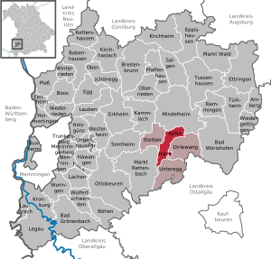
| Location of the community of Apfeltrach in the Unterallgäu district | ||
  |
||

Apfeltrach is a municipality in the Swabian district of Unterallgäu . The community is a member of the Dirlewang administrative community .
geography
The community is located in the Donau-Iller region in Central Swabia .
The municipality consists of the districts Apfeltrach, Köngetried and Saulengrain.
There are five officially named parts of the municipality (the type of settlement is given in brackets ):
- Apfeltrach ( parish village )
- Grünegg ( village )
- Katzbrui ( wasteland )
- Köngetried (parish village)
- Saulengrain (village)
history
Until the church is planted
Apfeltrach was a nursing office before 1800 and belonged to the Augsburg Cathedral Monastery . Since the Reichsdeputationshauptschluss of 1803 the place belongs to Bavaria . In the course of the administrative reforms in the Kingdom of Bavaria , today's municipality was created with the municipal edict of 1818 .
Incorporations
On May 1, 1978, the previously independent communities of Köngetried and Saulengrain were incorporated.
Population development
| year | 1840 | 1900 | 1939 | 1950 | 1961 | 1970 | 1987 | 1991 | 1995 | 2000 | 2005 | 2010 | 2015 |
| Residents | 622 | 675 | 692 | 1032 | 818 | 781 | 842 | 896 | 948 | 926 | 986 | 960 | 919 |
Between 1988 and 2018, the community grew from 845 to 935 by 90 inhabitants or 10.7%.
politics
Mayoress and councilor
Karin Schmalholz ( FW ) has been mayor since 2011 ; she was confirmed in office on March 15, 2020 with 73.7% of the votes for a further six years.
The allocation of seats in the local elections on March 15, 2020 was as follows:
- Appletrach village community: 5 seats
- Bürgerblock Köngetried: 2 seats
- Saulengrain voter community: 1 seat
This distribution of seats is unchanged from the 2014 to 2020 term of office.
tax income
In 2010 the municipal tax revenue was € 422,000, of which € 51,000 was trade tax revenue (net).
coat of arms
The coat of arms was approved by the government of Swabia on April 15, 1988.
Blazon : "Split of red and silver, a golden bishop's staff and a silver palm branch crossed diagonally at the front, a red apple with a green stem and green leaf above a lowered blue wavy bar."
The history of the municipality was primarily determined by the Augsburg bishopric. Apfeltrach belonged to the properties of the cathedral chapter and was the seat of its own office (since the 18th century the upper bailiff). As a reference to this historical connection, the coat of arms was split from red and silver based on the model of the Augsburg Hochstift coat of arms. The crosier refers to the St. Nikolaus church in Saulengrain, the palm branch as a martyr attribute stands for the Stefanskirche in Köngetried. The apple in the back field “speaks” for the place name Apfeltrach. The wave bar symbolizes the two rivers Westernach and Mindel .
Freising's Theodor Goerge was responsible for the design and design of the coat of arms.
flag
The flag is striped yellow and red with the municipal coat of arms.
Culture and sights

St. Bartholomew
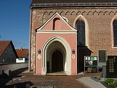
St. Bartholomew's entrance

.jpg)
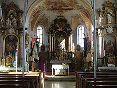
St. Bartholomew interior

St. Leonhard


In Apfeltrach there is the 15th century church of St. Bartholomäus and the pilgrimage church of St. Leonhard from the same time . The chapel to the 14 helpers in need is located on a former plague cemetery and was built in the first half of the 17th century.
Architectural monuments
Economy including agriculture and forestry
In 1998 there were five employees in the agricultural and forestry sector and 59 in the manufacturing sector at the place of work (no in the trade and transport sector); There were a total of 285 employees at the place of residence subject to social insurance contributions. There were ten in the manufacturing sector and two in the construction sector. In 1999 there were also 49 farms with an agriculturally used area of 1056 hectares, of which 852 hectares were permanently green.
Sons and daughters of the church
- Franz Burger (1880–1933), classical philologist and high school teacher
- Irmgard Seefried (1919–1988), lyric soprano
Web links
- Homepage
- Entry on the coat of arms of Apfeltrach in the database of the House of Bavarian History
Individual evidence
- ↑ "Data 2" sheet, Statistical Report A1200C 202041 Population of the municipalities, districts and administrative districts 1st quarter 2020 (population based on the 2011 census) ( help ).
- ↑ Community of Apfeltrach: Community council of the community of Apfeltrach. Retrieved May 16, 2020 .
- ^ Community Apfeltrach in the local database of the Bavarian State Library Online . Bayerische Staatsbibliothek, accessed on August 17, 2019.
- ^ Federal Statistical Office (ed.): Historical municipality directory for the Federal Republic of Germany. Name, border and key number changes in municipalities, counties and administrative districts from May 27, 1970 to December 31, 1982 . W. Kohlhammer, Stuttgart / Mainz 1983, ISBN 3-17-003263-1 , p. 783 .
- ↑ Community of Apfeltrach: Historical overview of Apfeltrach, Köngetried and Saulengrain. Retrieved May 24, 2020 .
- ↑ Second votes, according to the source www.wahlen.bayern.de, accessed on March 4, 2018

Amberg |
Apple trach |
Babenhausen |
Bad Grönenbach |
Bad Wörishofen |
Benningen |
Boars |
Boos |
Breitenbrunn |
Buxheim |
Dirlewang |
Egg an der Günz |
Eppishausen |
Erkheim |
Ettringen |
Fellheim |
Hawangen |
Heimertingen |
Holzgünz |
Kammlach |
Kettershausen |
Kirchhaslach |
Kirchheim in Swabia |
Kronburg |
Laughter |
Arbors |
Lautrach |
Legau |
Market Rettenbach |
Market forest |
Memmingerberg |
Mindelheim |
Niederrieden |
Oberrieden |
Oberschönegg |
Ottobeuren |
Pfaffenhausen |
Pleas |
Rammingen |
Salgae |
Sontheim |
Stetten |
Trunkelsberg |
Türkheim |
Tussenhausen |
Ungerhausen |
Unteregg |
Westerheim |
Wiedergeltingen |
Winter peace |
Wolfertschwenden |
Woringen
Municipality-free area in the district of Unterallgäu
Ungerhauser Wald