Saint-Hilaire-Saint-Mesmin
| Saint-Hilaire-Saint-Mesmin | ||
|---|---|---|

|
|
|
| region | Center-Val de Loire | |
| Department | Loiret | |
| Arrondissement | Orleans | |
| Canton | Olivet | |
| Community association | Orléans metropolis | |
| Coordinates | 47 ° 52 ′ N , 1 ° 50 ′ E | |
| height | 87-105 m | |
| surface | 14.12 km 2 | |
| Residents | 3,040 (January 1, 2017) | |
| Population density | 215 inhabitants / km 2 | |
| Post Code | 45160 | |
| INSEE code | 45282 | |
| Website | http://www.saint-hilaire-saint-mesmin.fr/ | |
 Town hall of Saint-Hilaire-Saint-Mesmin |
||
Saint-Hilaire-Saint-Mesmin is a French commune with 3,040 inhabitants (as of January 1 2017) in the department of Loiret in the region Center-Val de Loire . The municipality is located in the Arrondissement of Orléans and belongs to the canton of Olivet . The inhabitants are called Hilairois .
geography
Saint-Hilaire-Saint-Mesmin is located on the Loiret River . Saint-Hilaire-Saint-Mesmin is surrounded by the neighboring communities of Saint-Pryvé-Saint-Mesmin in the north, Olivet in the east, Ardon in the southeast, Mézières-lez-Cléry in the south and Mareau-aux-Pres in the west.
Population development
| year | 1962 | 1968 | 1975 | 1982 | 1990 | 1999 | 2006 | 2017 |
| Residents | 1418 | 1623 | 1835 | 1775 | 2025 | 2353 | 2592 | 3040 |
Attractions
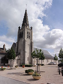
- Saint-Hilaire church, built in the 11th century, 13th century alterations, 16th century bell tower, monument historique
- Town hall, part of the former La Pie domain
- Saint-Nicolas bridge from the 13th century, rebuilt in 1676 after being demolished
Personalities
- François de Lorraine, duc de Guise (1519–1563), general, murdered here by Jean de Poltrot
Parish partnership
There is a partnership with the German community of Erkheim in Swabia (Bavaria).
Web links
Commons : Saint-Hilaire-Saint-Mesmin - Collection of images, videos and audio files

