
Coulmiers
| Coulmiers | ||
|---|---|---|
.svg)
|
|
|
| region | Center-Val de Loire | |
| Department | Loiret | |
| Arrondissement | Orleans | |
| Canton | Meung-sur-Loire | |
| Community association | Terres du Val de Loire | |
| Coordinates | 47 ° 56 ' N , 1 ° 40' E | |
| height | 108-121 m | |
| surface | 14.28 km 2 | |
| Residents | 536 (January 1, 2017) | |
| Population density | 38 inhabitants / km 2 | |
| Post Code | 45130 | |
| INSEE code | 45109 | |
| Website | http://www.mairiecoulmiers.fr/ | |
 Coulmiers Town Hall |
||

Coulmiers is a French municipality with 536 inhabitants (as of January 1 2017) in the department of Loiret in the region Center-Val de Loire ; it belongs to the Arrondissement Orléans and the canton Meung-sur-Loire . The inhabitants are called Colmériens .
geography
Coulmiers is located about 22 kilometers west-northwest of Orléans in the Beauce . Coulmiers is surrounded by the neighboring communities of Épieds-en-Beauce in the north and north-west, Gémigny in the north-east, Rozières-en-Beauce in the east, Huisseau-sur-Mauves in the south and south-east, Baccon in the south and south-west and Charsonville in the west.
history
On November 9, 1870, the French troops succeeded in defeating a Bavarian corps in the Battle of Coulmiers during the Franco-Prussian War of 1870/71 , thereby seriously disrupting the German security for the advance on Paris.
Population development
| year | 1962 | 1968 | 1975 | 1982 | 1990 | 1999 | 2008 | 2013 |
| Residents | 326 | 302 | 301 | 521 | 591 | 559 | 522 | 561 |
| Source: Cassini and INSEE | ||||||||
Attractions
- Saint-Aignan church, originally from the 12th century, remodeled in the 17th century, restored in 1875
- Coulmiers Tumulus and Dolmen
- Two castles from the 18th and 19th centuries
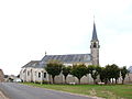
Saint-Aignan church

War memorial

