Saint-Cyr-en-Val
| Saint-Cyr-en-Val | ||
|---|---|---|

|
|
|
| region | Center-Val de Loire | |
| Department | Loiret | |
| Arrondissement | Orleans | |
| Canton | La Ferté-Saint-Aubin | |
| Community association | Orléans metropolis | |
| Coordinates | 47 ° 50 ′ N , 1 ° 58 ′ E | |
| height | 92-126 m | |
| surface | 44.23 km 2 | |
| Residents | 3,309 (January 1, 2017) | |
| Population density | 75 inhabitants / km 2 | |
| Post Code | 45590 | |
| INSEE code | 45272 | |
| Website | http://www.mairie-saintcyrenval.fr/ | |
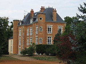
 The Château de la Motte in Saint-Cyr-en-Val |
||
Saint-Cyr-en-Val is a French commune with 3,309 inhabitants (as of January 1, 2017) in the Loiret department in the Center-Val de Loire region .
geography
The municipality is located about 10 kilometers southeast of Orléans , on the border of two different natural landscapes, the Loire valley , to which the northern part of the municipality belongs, and the Sologne in the south. The municipality is crossed by the Dhuy River.
history
Saint-Cyr-en-Val has been inhabited for several millennia. In the Middle Ages , the village developed around La Mothe Castle (which was later rebuilt). Joan of Arc stayed here on April 29, 1429, shortly before she liberated the city of Orléans from the English.
In 1959 the municipality sold an area of several square kilometers to the municipality of Orléans . In the 1960s, the “La Source” district and the Orléans University campus and the “Parc Floral” park, where the source of the Loiret river can be seen, were built on the area sold.
Partner communities
In the 1990s, the community formed a town partnership with the Bliesen district of the city of St. Wendel in Saarland .
traffic
The avenue de la Paris , the Départementstraße 2020, leads through the town coming from Orléans to Vierzon . The Saint-Cyr-en-Val train station is on the Orléans- Montauban railway line .
