Vennecy
| Vennecy | ||
|---|---|---|

|
|
|
| region | Center-Val de Loire | |
| Department | Loiret | |
| Arrondissement | Orleans | |
| Canton | Fleury-les-Aubrais | |
| Community association | La Foret | |
| Coordinates | 47 ° 57 ' N , 2 ° 3' E | |
| height | 106-135 m | |
| surface | 11 km 2 | |
| Residents | 1,812 (January 1, 2017) | |
| Population density | 165 inhabitants / km 2 | |
| Post Code | 45470 | |
| INSEE code | 45333 | |
| Website | http://www.vennecy.fr/ | |
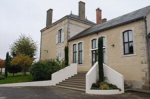
 Vennecy Town Hall |
||
Vennecy is a French commune with 1,812 inhabitants (as of January 1 2017) in the department of Loiret in the region Center-Val de Loire . It belongs to the Arrondissement Orléans , is part of the canton of Fleury-les-Aubrais (until 2015: canton of Neuville-aux-Bois ) and of the community association La Forêt . The inhabitants are called Venetiens .
geography
Vennecy is 14 kilometers northeast of Orléans . The Forêt d'Orléans , an approximately 150,000 hectare forest area, spreads northwest of the village . Vennecy is surrounded by the neighboring communities of Loury in the north, Traînou in the east and northeast, Boigny-sur-Bionne in the south and southwest and Marigny-les-Usages in the west.
Population development
| 1962 | 1968 | 1975 | 1982 | 1990 | 1999 | 2006 | 2013 |
|---|---|---|---|---|---|---|---|
| 501 | 543 | 731 | 932 | 987 | 1,299 | 1,362 | 1,537 |
| Source: Cassini and INSEE | |||||||
Attractions
- Saint-Symphorien Church
Personalities
- Jules Lemaître (1853-1914), playwright
Web links
Commons : Vennecy - collection of images, videos and audio files

