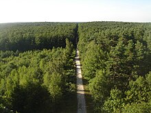
Forêt d'Orléans
The Forêt d'Orléans ( Forest of Orléans ) is a large forest area ( domain forest , Forêt domaniale ) in the north of the French city of Orléans in the Loiret department . It forms part of the Natura 2000 network .
History and location
The forest, formerly known as Forêt des Loges , came to the French royal family at the end of the 10th century.
The 50,000 hectare forest is spread over 35 municipalities, 35,000 hectares are state-owned ( Forêt domaniale d'Orléans , the largest forest domain in France). It extends between the landscapes of the Beauce , the Gâtinais and the Loire Valley between the cities of Orléans and Gien and in the north almost to the city of Pithiviers . Its original area was around 150,000 hectares.
The following municipalities have a share in the state forest:
- Boiscommun
- Les Bordes
- Bougy-lez-Neuville
- Bouzy-la-Forêt
- Bray-en-Val
- Cercottes
- Chambon-la-Forêt
- Chanteau
- Châteauneuf-sur-Loire
- Châtenoy
- Chevilly
- Chilleurs-aux-Bois
- Les Choux
- Combreux
- Coudroy
- Courcy-aux-Loges
- Dampierre-en-Burly
- Fay-aux-Loges
- Fleury-les-Aubrais
- Ingrannes
- Lorris
- Loury
- Le Moulinet-sur-Solin
- Montereau
- Nesploy
- Neuville-aux-Bois
- Nibelle
- Ouzouer-sur-Loire
- Rebréchien
- Saint-Lyé-la-Forêt
- Saran
- Seichebrières
- Semoy
- Sully-la-Chapelle
- Saint-Martin-d'Abbat
- Sury-aux-Bois
- Traînou
- Vieilles-Maisons-sur-Joudry
- Vitry-aux-Loges
- Vrigny
The remains of the former Cistercian monastery of La Cour-Dieu lie in the forest . The long-distance hiking trails GR 3 and GR 32 of the French GR long-distance hiking trail network run through the forest.
geology
The subsoil of the forest, which has only a low relief (height between 107 and 178 m), consists of tertiary sands and clays .
Flora and fauna
The forest is a mixed forest in which the oak stands make up more than half of the tree population. The conifers are mainly Scots pines , which cover around a third of the forest.
The osprey was reintroduced in 1984. In addition, the coming booted eagle , the short-toed eagle , the honey buzzard , the hen harrier , the nightjar ago. In mammals u. a. Red deer , roe deer , hare and squirrel represented.
Web links
ONF website (French), accessed on July 17, 2018 Coordinates: 48 ° 0 ′ 28 ″ N , 2 ° 9 ′ 39 ″ E


