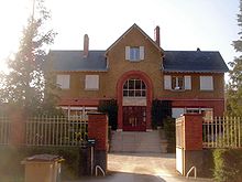
Chambon-la-Forêt
| Chambon-la-Forêt | ||
|---|---|---|

|
|
|
| region | Center-Val de Loire | |
| Department | Loiret | |
| Arrondissement | Pithiviers | |
| Canton | Malesherbes | |
| Community association | Pithiverais-Gâtinais | |
| Coordinates | 48 ° 4 ′ N , 2 ° 18 ′ E | |
| surface | 17.16 km 2 | |
| Residents | 942 (January 1, 2017) | |
| Population density | 55 inhabitants / km 2 | |
| Post Code | 45340 | |
| INSEE code | 45069 | |
Chambon-la-Forêt is a commune of 942 inhabitants (as of January 1 2017) in the district Pithiviers in Loiret in the region Center-Val de Loire . The municipality belongs to the canton of Malesherbes (until 2015: canton of Beaune-la-Rolande ). The inhabitants are called Chambonnais (also: Chambonniots ).
geography
Chambon-la-Forêt is about 110 kilometers south of Paris and about 30 kilometers northeast of Orléans . To the southwest is the Orléans Forest . Chambon-la-Forêt is surrounded by the neighboring communities Bouilly-en-Gâtinais in the north, Nancray-sur-Rimarde in the east, Nibelle in the south and south-east, Ingrannes in the south-west and Vrigny in the north-west.
Population development
| year | 1962 | 1968 | 1975 | 1982 | 1990 | 1999 | 2006 | 2013 |
| Residents | 472 | 463 | 449 | 491 | 589 | 625 | 709 | 934 |
| Source: Cassini and INSEE | ||||||||
Attractions
- Saint-Etienne church
- national geomagnetic observatory
Web links
Commons : Chambon-la-Forêt - collection of images, videos and audio files

