
Courcelles-le-Roi
| Courcelles-le-Roi | ||
|---|---|---|
.svg)
|
|
|
| region | Center-Val de Loire | |
| Department | Loiret | |
| Arrondissement | Pithiviers | |
| Canton | Malesherbes | |
| Community association | Pithiverais-Gâtinais | |
| Coordinates | 48 ° 6 ′ N , 2 ° 19 ′ E | |
| height | 97-118 m | |
| surface | 6.3 km 2 | |
| Residents | 309 (January 1, 2017) | |
| Population density | 49 inhabitants / km 2 | |
| Post Code | 45300 | |
| INSEE code | 45110 | |
 Mairie of Courcelles-le-Roi |
||

Courcelles-le-Roi is a French municipality with 309 inhabitants (at January 1, 2017) in the Loiret in the region Center-Val de Loire . It belongs to the canton of Malesherbes and the Arrondissement of Pithiviers .
The municipality, originally named Courcelles, changed its name to the current name Courcelles-le-Roi by decree N ° 2018-956 of November 5, 2018 .
location
The place is on the Rimarde River . The commune is bordered by Yèvre-la-Ville to the north, Boynes to the northeast, Batilly-en-Gâtinais to the east, Nancray-sur-Rimarde to the south and Bouilly-en-Gâtinais to the west .
Population development
| year | 1962 | 1968 | 1975 | 1982 | 1990 | 1999 | 2008 | 2015 |
|---|---|---|---|---|---|---|---|---|
| Residents | 255 | 213 | 195 | 230 | 248 | 251 | 276 | 296 |
Attractions
- Courcelles castle with parts from the 15th century, Monument historique
- Saint-Jacques-le-Majeur church and Saint-Hubert chapel with parts from the 12th century, Monument historique

Courcelles Castle

Saint-Jacques-le-Majeur church
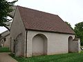
Saint-Hubert chapel

_-_%C3%89glise_Saint-Jacques-le-Majeur_-_1.jpg)
_-_Chapelle_Saint-Hubert_-_1.jpg)
Web links
Commons : Courcelles-le-Roi - collection of images, videos and audio files
Individual evidence
- ↑ Decree N ° 2018-956 of November 5, 2018 on the renaming of the municipality .
- ↑ Castle of Courcelles in the Base Mérimée of the French Ministry of Culture (French)
- ↑ Saint-Jacques-le-Majeur Church in the Base Mérimée of the French Ministry of Culture (French)