Givraines
| Givraines | ||
|---|---|---|
|
|
||
| region | Center-Val de Loire | |
| Department | Loiret | |
| Arrondissement | Pithiviers | |
| Canton | Malesherbes | |
| Community association | Communauté de communes du Pithiverais | |
| Coordinates | 48 ° 9 ' N , 2 ° 22' E | |
| height | 95-127 m | |
| surface | 11.26 km 2 | |
| Residents | 414 (January 1, 2017) | |
| Population density | 37 inhabitants / km 2 | |
| Post Code | 45300 | |
| INSEE code | 45157 | |
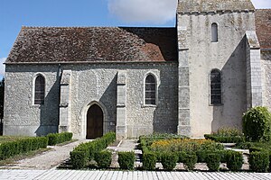
 Saint-Aignan and Saint-Roch church |
||
Givraines is a French commune 414 inhabitants (as of January 1 2017) in the Loiret in the region Center-Val de Loire . It belongs to the canton of Malesherbes and the Arrondissement of Pithiviers .
It is bordered to the north by La Neuville-sur-Essonne , to the north-east by Échilleuses , to the east by Boësses , to the south-east by Gaubertin , to the south by Barville-en-Gâtinais , to the south-west by Boynes and to the west by Yèvre-la-Ville ( with the main settlement and the former municipality of Yèvre-le-Châtel).
Population development
| year | 1962 | 1968 | 1975 | 1982 | 1990 | 1999 | 2008 | 2015 |
|---|---|---|---|---|---|---|---|---|
| Residents | 378 | 354 | 308 | 284 | 326 | 306 | 339 | 421 |
Web links
Commons : Givraines - collection of images, videos and audio files
