Greneville-en-Beauce
| Greneville-en-Beauce | ||
|---|---|---|

|
|
|
| region | Center-Val de Loire | |
| Department | Loiret | |
| Arrondissement | Pithiviers | |
| Canton | Pithiviers | |
| Community association | Plaine du Nord Loiret | |
| Coordinates | 48 ° 11 ' N , 2 ° 7' E | |
| height | 114-137 m | |
| surface | 22.47 km 2 | |
| Residents | 700 (January 1, 2017) | |
| Population density | 31 inhabitants / km 2 | |
| Post Code | 45480 | |
| INSEE code | 45160 | |
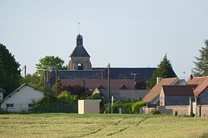
 Center of Greneville-en-Beauce with Saint-Pierre-ès-Liens church |
||
Greneville-en-Beauce is a French commune of 700 inhabitants (as of January 1, 2017) in the department of Loiret in the region Center-Val de Loire . It belongs to the Arrondissement of Pithiviers and the Canton of Pithiviers (until 2015: Canton Outarville ). The inhabitants are called Grenevillois .
geography
Greneville-en-Beauce is located about 34 kilometers north-northeast of Orléans . Greneville-en-Beauce is surrounded by the neighboring communities of Léouville in the north and north-west, Charmont-en-Beauce in the north, Guigneville in the east and north-east, Pithiviers-le-Vieil in the east and south-east, Jouy-en-Pithiverais in the south and south-east, Châtillon-le-Roi in the south, Bazoches-les-Gallerandes in the west and south-west and Outarville in the west and north-west.
Population development
| year | 1962 | 1968 | 1975 | 1982 | 1990 | 1999 | 2008 | 2013 |
| Residents | 417 | 409 | 553 | 519 | 581 | 584 | 639 | 668 |
| Source: Cassini and INSEE | ||||||||
Attractions
- Saint-Pierre-ès-Liens church from the 12th / 13th centuries Century, renovations from the 15th century, Monument historique since 1931
- Saint-Félix church in the town of Guignonville, built at the beginning of the 13th century, monument historique since 1925
- Grasville Mill
Web links

