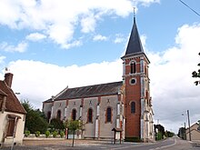
Les Choux
| Les Choux | ||
|---|---|---|

|
|
|
| region | Center-Val de Loire | |
| Department | Loiret | |
| Arrondissement | Montargis | |
| Canton | Gien | |
| Community association | Giennoises | |
| Coordinates | 47 ° 48 ' N , 2 ° 41' E | |
| height | 123-177 m | |
| surface | 33.36 km 2 | |
| Residents | 515 (January 1, 2017) | |
| Population density | 15 inhabitants / km 2 | |
| Post Code | 45290 | |
| INSEE code | 45096 | |
 Town hall (Mairie) of Les Choux |
||
Les Choux is a French municipality with 515 inhabitants (as of January 1 2017) in the department of Loiret in the region Center-Val de Loire ; it belongs to the arrondissement of Montargis and the canton of Gien . The inhabitants are called Choésiens .
geography
Les Choux is located about 50 kilometers east-southeast of Orléans am Puiseaux . Les Choux is surrounded by the neighboring communities of Langesse in the north and north-west, Nogent-sur-Vernisson in the north-east, Boismorand in the east, Gien in the south, Nevoy in the south-west, Dampierre-en-Burly in the west and Le Moulinet-sur-Sorlin in the north-west.
The municipality had a stop on the Moret-Veneux-les-Sablons-Lyon-Perrache railway line in the municipality of Boismorand, which is no longer served today.
Population development
| 1962 | 1968 | 1975 | 1982 | 1990 | 1999 | 2006 | 2013 |
|---|---|---|---|---|---|---|---|
| 442 | 564 | 332 | 350 | 377 | 451 | 497 | 478 |
| Source: Cassini and INSEE | |||||||
Attractions
- Saint-Cyr church
- Guy Lux mansion

