
Saint-Gondon
| Saint-Gondon | ||
|---|---|---|
.svg)
|
|
|
| region | Center-Val de Loire | |
| Department | Loiret | |
| Arrondissement | Montargis | |
| Canton | Sully-sur-Loire | |
| Community association | Giennoises | |
| Coordinates | 47 ° 42 ' N , 2 ° 33' E | |
| height | 117-164 m | |
| surface | 22.4 km 2 | |
| Residents | 1,109 (January 1, 2017) | |
| Population density | 50 inhabitants / km 2 | |
| Post Code | 45500 | |
| INSEE code | 45280 | |
| Website | http://saintgondon.free.fr/ | |

Saint-Gondon is a French commune with 1,109 inhabitants (as of January 1 2017) in the department of Loiret in the region Center-Val de Loire ; it belongs to the arrondissement of Montargis and the canton of Sully-sur-Loire (until 2015: canton of Gien ). The inhabitants are called Gondulfiens .
geography
Saint-Gondon is located about 52 kilometers east-southeast of Orléans on the Loire . Saint-Gondon is surrounded by the neighboring municipalities of Dampierre-en-Burly in the north and north-west, Nevoy in the north and north-east, Poilly-lez-Gien in the east and south-east, Goullons in the south, Saint-Florent in the west and Lion-en-Sullias in the West and northwest.
Population development
| 1962 | 1968 | 1975 | 1982 | 1990 | 1999 | 2006 | 2017 |
|---|---|---|---|---|---|---|---|
| 550 | 540 | 576 | 683 | 778 | 875 | 1024 | 1109 |
| Sources: Cassini and INSEE | |||||||
Attractions
- Menhir
- Saint-Gondon church from the 11th century, alterations from the 16th century, monument historique since 1943
- 15th century priory, monument historique since 1975
- Ruins of the former hill fort with donjon from the 11th century, monument historique since 1971
- Dominus Castle from the 18th century
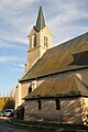
Saint Gondon Church

Ruins of the Wallburg (Motte) with donjon


Web links
Commons : Saint-Gondon - Collection of images, videos and audio files