
Merinville
| Merinville | ||
|---|---|---|
|
||
| region | Center-Val de Loire | |
| Department | Loiret | |
| Arrondissement | Montargis | |
| Canton | Courtenay | |
| Community association | Cléry, Betz et l'Ouanne | |
| Coordinates | 48 ° 5 ' N , 2 ° 57' E | |
| height | 127-149 m | |
| surface | 11.84 km 2 | |
| Residents | 185 (January 1, 2017) | |
| Population density | 16 inhabitants / km 2 | |
| Post Code | 45210 | |
| INSEE code | 45201 | |
| Website | https://www.merinville.fr/ | |
 City Hall (Mairie) of Mérinville |
||

Mérinville is a French municipality with 185 inhabitants (as of January 1 2017) in the department of Loiret in the region Center-Val de Loire . It belongs to the arrondissement of Montargis and is part of the canton of Courtenay . The inhabitants are called Mérinvillois .
geography
Mérinville is about 76 kilometers east-northeast of Orléans . Neighboring municipalities of Mérinville are Rozoy-le-Vieil in the north, Ervauville in the east, Courtemaux in the south and south-east, Saint-Loup-de-Gonois in the south, La Selle-sur-le-Bied in the west and south-west and Pers-en-Gâtinais in the north-west.
Population development
| year | 1962 | 1968 | 1975 | 1982 | 1990 | 1999 | 2006 | 2013 |
| Residents | 126 | 118 | 115 | 110 | 88 | 109 | 155 | 179 |
| Source: Cassini and INSEE | ||||||||
Attractions
- Saint-Aignan church
- Le Pin castle from the 17th century
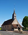
Saint-Aignan church
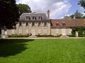
Le Pin Castle


Web links
Commons : Mérinville - collection of images, videos and audio files