Nogent-sur-Vernisson
| Nogent-sur-Vernisson | ||
|---|---|---|
|
|
||
| region | Center-Val de Loire | |
| Department | Loiret | |
| Arrondissement | Montargis | |
| Canton | Lorris | |
| Community association | Canaux et Forêts en Gâtinais | |
| Coordinates | 47 ° 51 ′ N , 2 ° 45 ′ E | |
| height | 109-150 m | |
| surface | 33.27 km 2 | |
| Residents | 2,556 (January 1, 2017) | |
| Population density | 77 inhabitants / km 2 | |
| Post Code | 45290 | |
| INSEE code | 45229 | |
| Website | www.nogentsurvernisson.fr | |
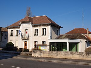
 Town hall of Nogent-sur-Vernisson |
||
Nogent-sur-Vernisson is a French commune with 2,556 inhabitants (as of January 1 2017) in the department of Loiret in the region Center-Val de Loire . The municipality belongs to the arrondissement of Montargis and the canton of Lorris (until 2015: Châtillon-Coligny ). The inhabitants are called Nogentais .
geography
Nogent-sur-Vernisson is located in central France in the Gâtinais countryside on the eastern edge of the Loiret department on the Vernisson River . Nogent-sur-Vernisson is surrounded by the neighboring communities of Pressigny-les-Pins in the north, Montbouy in the east and northeast, Sainte-Geneviève-des-Bois in the southeast, Boismorand in the south, Les Choux and Langesse in the southwest and Varennes-Changy in the west and northwest.
The Autoroute A77 and the former Route nationale 7 (today D2007) cross the municipality.
Since 1861, the municipality has a railway station on the railway line Moret-Veneux-les-Sablons-Lyon-Perrache which trains of TER Center-Val de Loire the connection Paris-Bercy - Nevers is operated.
Population development
| 1962 | 1968 | 1975 | 1982 | 1990 | 1999 | 2006 | 2012 |
|---|---|---|---|---|---|---|---|
| 1,550 | 1,756 | 2.016 | 2,414 | 2,357 | 2,443 | 2,502 | 2,593 |
Attractions
- Saint-Martin church from the 12th century
- Arboretum Barres
- Wall remains from Roman times
Parish partnership
There is a partnership with the Irish community of Castleblayney in County Monaghan (Ulster) .


