
Saint-Hilaire-sur-Puiseaux
| Saint-Hilaire-sur-Puiseaux | ||
|---|---|---|
|
||
| region | Center-Val de Loire | |
| Department | Loiret | |
| Arrondissement | Montargis | |
| Canton | Lorris | |
| Community association | Canaux et Forêts en Gâtinais | |
| Coordinates | 47 ° 54 ' N , 2 ° 42' E | |
| height | 96-110 m | |
| surface | 11.34 km 2 | |
| Residents | 175 (January 1, 2017) | |
| Population density | 15 inhabitants / km 2 | |
| Post Code | 45700 | |
| INSEE code | 45283 | |
 Town hall of Saint-Hilaire-sur-Puiseaux |
||

Saint-Hilaire-sur-Puiseaux is a commune with 175 inhabitants (as of January 1 2017) in the department of Loiret in the region Center-Val de Loire . It is part of the canton of Lorris in the arrondissement of Montargis .
geography
Saint-Hilaire-sur-Puiseaux is about 62 kilometers east of Orléans am Puiseaux . Saint-Hilaire-sur-Puiseaux is surrounded by the neighboring municipalities of Vimory in the north and northwest, Mormant-sur-Vernisson in the northeast, Solterre in the east, Ouzouer-des-Champs in the south, Varennes-Changy in the southwest and Oussoy-en-Gâtinais in the West.
Population development
| 1962 | 1968 | 1975 | 1982 | 1990 | 1999 | 2006 | 2013 | |
|---|---|---|---|---|---|---|---|---|
| 158 | 155 | 127 | 113 | 140 | 163 | 177 | 167 | |
| Source: Cassini and INSEE | ||||||||
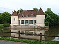
Attractions
- Saint-Hilaire church
- lock

Saint-Hilaire church
lock


Web links
Commons : Saint-Hilaire-sur-Puiseaux - Collection of images, videos and audio files