
Montbouy
| Montbouy | ||
|---|---|---|
|
||
| region | Center-Val de Loire | |
| Department | Loiret | |
| Arrondissement | Montargis | |
| Canton | Lorris | |
| Community association | Canaux et Forêts en Gâtinais | |
| Coordinates | 47 ° 52 ' N , 2 ° 49' E | |
| height | 102-154 m | |
| surface | 26.73 km 2 | |
| Residents | 739 (January 1, 2017) | |
| Population density | 28 inhabitants / km 2 | |
| Post Code | 45230 | |
| INSEE code | 45210 | |
| Website | http://montbouy.fr/ | |
 Montbouy Town Hall |
||

Montbouy is a French municipality with 739 inhabitants (as of January 1 2017) in the department of Loiret in the region Center-Val de Loire . The municipality belongs to the arrondissement of Montargis and the canton of Lorris (until 2015: canton of Châtillon-Coligny ). The inhabitants are called Montboviens .
geography
Montbouy is located about 68 kilometers east-southeast of Orléans in central France in the Gâtinais landscape on the eastern edge of the Loiret department on the Loing River , into which the Aveyron flows here, and on the Canal de Briare . Montbouy is surrounded by the neighboring municipalities of Montcresson in the north, Gy-les-Nonains in the north and northeast, Châteaurenard in the northeast, La Chapelle-sur-Aveyron in the east, Châtillon-Coligny in the southeast, Sainte-Geneviève-des-Bois in the south, Nogent -sur-Vernisson to the west and south-west and Pressigny-les-Pins to the west.
Population development
| 1962 | 1968 | 1975 | 1982 | 1990 | 1999 | 2006 | 2013 |
|---|---|---|---|---|---|---|---|
| 582 | 613 | 541 | 617 | 629 | 688 | 732 | 745 |
| Source: Cassini and INSEE | |||||||
Attractions
- Remains of a Gallo-Roman or Celtic settlement with the amphitheater of Chenevières
- Notre-Dame-et-Saint-Blaise church, originally from the 11th century, alterations from the later centuries
- Commandery of the Order of St. John
- Old rectory from 1734, today's town hall

Chenevières amphitheater

Notre-Dame-et-Saint-Blaise church
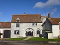
Commandery of the Order of St. John


