Saint-Firmin-sur-Loire
| Saint-Firmin-sur-Loire | ||
|---|---|---|
|
|
||
| region | Center-Val de Loire | |
| Department | Loiret | |
| Arrondissement | Montargis | |
| Canton | Gien | |
| Community association | Berry Loire Puisaye | |
| Coordinates | 47 ° 38 ′ N , 2 ° 44 ′ E | |
| height | 126-234 m | |
| surface | 24.76 km 2 | |
| Residents | 521 (January 1, 2017) | |
| Population density | 21 inhabitants / km 2 | |
| Post Code | 45360 | |
| INSEE code | 45276 | |
Saint-Firmin-sur-Loire is a French commune with a population of 521 (as at 1st January 2017) in the department of Loiret in the region Center-Val de Loire . It belongs to the arrondissement of Montargis and is part of the canton of Gien (until 2015: canton of Châtillon-sur-Loire ). The inhabitants are called Saint-Firminois .
geography
Saint-Firmin-sur-Loire is located on the left bank of the Loire and on the parallel canal Canal latéral à la Loire (German: Loire Lateral Canal ), which branches off from the Loire here. Neighboring municipalities of Saint-Firmin-sur-Loire are Saint-Brisson-sur-Loire in the north and north-west, Briare in the north and north-east, Châtillon-sur-Loire in the south and south-east, Cernoy-en-Berry in the south and south-west and Autry- le-Châtel to the west and south-west.
The former route nationale 726 (today's D926) runs through the municipality .
Population development
| year | 1962 | 1968 | 1975 | 1982 | 1990 | 1999 | 2006 | 2012 |
| Residents | 503 | 475 | 445 | 465 | 509 | 554 | 516 | 525 |
| Source: Cassini and INSEE | ||||||||
Attractions
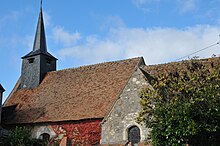
- Saint-Firmin church
- Briare Canal Bridge ( Monument historique )
- House Passeur
- Nature reserve on the Loire

